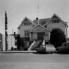
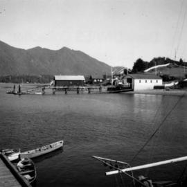
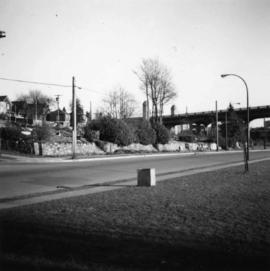
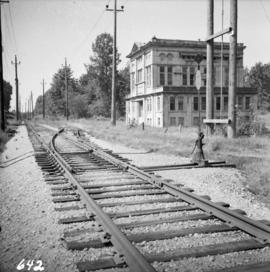
Photograph depicts a corner building on Chilco and West Georgia St. facing Stanley Park in Vancouver, B.C. The view is looking east across Chilco St.
Photograph depicts the site of a former C.P.R. connection between the mainline into Vancouver and False Creek yards at West Pender St. In Vancouver. The rails are not used but still appear in the street and on the parking lot on the far side. Another parallel set of tracks 30 yards to the east are in daily use.
Photograph depicts the Silver Ledge Hotel, Ainsworth Hot Springs, on the west side of Kootenay Lake, north of Nelson.
Photograph depicts a barn at Darfield, near Barriere, about 35 miles north of Kamloops. The English timbered cottage developed from this architectural form.
Photograph depicts East Pender St., looking west towards the Vancouver Sun newspaper office near Abbot St. in Vancouver, B.C.
Photograph depicts the Upper Clearwater Hall on a dirt road between Clearwater (70 miles north of Kamloops) and the entrance to Wells Gray Provincial Park. The cracks between the logs recently re-cemented.
Photograph depicts a barn at Port Guichon, 1 mile west of Ladner, Delta.
Photograph depicts the Delta Municipal Hall on Main St. in Ladner, B.C.
Photograph depicts a disused schoolhouse with the dates "1925" and "1902" on it. It is on River Rd. on the south bank of the Fraser River in Delta, opposite the west end of Annacis Island.
Photograph depicts Alberni St. in the west end of Vancouver. It is directly opposite the Vehicle Testing Station, in the 1700 block. The view in the photo is looking east.
Photograph depicts a courthouse in Vancouver, B.C. surrounded by a fence with paintings.
Photograph depicts a painting on a fence outside a courthouse on Howe St. in Vancouver, B.C. The painting shows the natural grandeur of B.C. partially blocked out by a super motel with a bewildered moose forced to become an ornamental fountain. The whole forecourt is being bulldozed to make way for the Centennial fountain.
Photograph depicts a wharf at Sechelt village on the Sechelt Peninsula. The view is looking southeast towards Vancouver.
Photograph depicts Tofino on Vancouver Island. View taken from wharf with a lifeboat on slip.
Photograph depicts a house fire possibly on 1000 Beach Block and Thurlow St. , caused by a wrecking gang.
Photograph depicts house at #1053 Beach Ave. in Vancouver, B.C. Dan Davies was a resident at one time.
Photograph depicts home at #1053 Beach Ave., which is now fully demolished.
Photograph depicts a general view of Coal Harbour in Vancouver, looking southeast and south with Marine Building (downtown) on extreme left and Stanley Park (unseen) at extreme right.
Photograph depicts Simon Fraser University in Burnaby, B.C. The view is looking southwest from the mall towards the gym and sports arena.
Photograph depicts Simon Fraser University in Burnaby, B.C. The view is looking east towards the nearly completed water tower from the west inner face of the Academic Quadrangle.
Photograph depicts the general view of the waterfront buildings between Burrard and Thurlow St., in Vancouver Harbour looking northwest from Burrard St. The Immigration Building is on the left and the "Princess of Vancouver" (C.P.R.) is in the middle distance.
Photograph depicts the Britannia Copper Mine in Howe Sound. The view is looking southeast.
Photograph depicts a fence at Nicola village, 7 miles northeast of Merritt.
Photograph depicts a view of downtown Vancouver taken from the east end of False Creek at the foot of Terminal Ave. The view is looking northwest. In the middle distance on the left is the pier of a railway bridge taking the Great Northern Railway line into the city. It was demolished in about 1915-1920 when a new Great Northern station was constructed.
Photograph depicts Lund Harbour, looking north, 12 miles north of Powell River. It is the most northerly point on the mainland accessible by car, on this part of the coast. Lund is 92 car miles north of the ferry terminal at Langdale.
Photograph depicts the north bank of False Creek in Vancouver, B.C. The photograph was taken from the Cambie Bridge, with a view looking west.
Photograph depicts a C.P.R. way-freight at the disused Wellington Depot on the Esquimalt and Nanaimo Railway, 4 miles north of Nanaimo.
Photograph depicts the C.P.R. depot at Spences Bridge. The view is looking south and shows a northbound freight train moving along the track.
Photograph depicts the Courtenay terminus of the Esquimalt and Nanaimo Railway. The view is looking north.
Photograph depicts the Malahat station on the Esquimalt and Nanaimo Railway line, 20 miles north of Victoria on Vancouver Island. The view is looking south and there are no houses anywhere in the vicinity.
Photograph depicts the Nanaimo passenger depot of the Esquimalt and Nanaimo Railway (at right) and the E & N freight shed (at left).
Photograph depicts the junction station of the Esquimalt and Nanaimo Railway at Parksville on Vancouver Island. The view is looking south.
Photograph depicts the C.P.R. depot at Oliver. There is a way freight stopped at the depot, either before or after switching.
Photograph depicts the Cobble Hill Station on the Esquimalt and Nanaimo Railway on Vancouver Island. The view is looking south.
Photograph depicts the C.P.R. train station at Kaslo. At one time the line ran between Kaslo and Nakusp, via New Denver. It was lifted in 1915-1920. The trackage now consists of Kootenay Lake slip and about 1 mile of sidings. It is used mainly for oil (incoming) and lumber (outgoing).
Photograph depicts sheds and repair center of the C.P.R. at Victoria, near Lime Bay. The rail-liner just came in from the daily run to Courtenay.
Photograph depicts the Malahat Station on the Esquimalt and Nanaimo Railway on Vancouver Island. The view is looking south towards Victoria.
Photograph depicts a typical section shed scene anywhere in B.C. It was taken on the C.P.R. track near Flat Creek or Illecillewaet, between Rogers Pass and Revelstoke. The April 25, 1965 CPR Employee timetable lists the mileage at Illecillewaet as 98.2.
Photograph depicts a water tower.
Photograph depicts the west side of the C.P.R. engineering shops at Revelstoke. The building appeared to house a machine shop and had no cars or locomotives inside.
Photograph depicts the C.P.R. yards just west of downtown passenger station and in front of Pier B, owned by the C.P.R. The view is looking northwest from Burrard St.
Photograph depicts a depot and derelict electricity substation at Coghlan, 9 rail miles east of Langley, looking west.
Photograph depicts the Canadian National Railway (CN) Port Mann depot.
Photograph depicts the Great Northern Railway depot at Keremeos and the terminus of the line from Wenatchee, Washington, U.S.A. The line stops about 1/3 mile beyond this point. At one time it ran on to Hedley mine and possibly Princeton.
Photograph depicts a freight shed located on the north side of the rail line and some 200 yards west of the Mission City CPR depot.
Photograph depicts the CPR Mission Bridge on the Huntingdon Branch. The view is looking north from the open swing span. The bridge is about 1700 ft. long and consists of eight 160 ft. tress spans, one 230 ft. swing span, and 3 girder spans. Seven of the eight truss spans are seen in this view, with the Fraser River in freshet.
Photograph depicts the CPR Mission Bridge on the Huntingdon Branch. It shows the daily southbound way freight train at about 12:30 hours STD time, crossing the bridge. The train consisted of two locomotives, about 35 cars, and a 1920 wooden caboose. The lead locomotive was CPR 8510, GM class 0-4-4-0, built in 1954. There is a 10 mph speed restriction on the bridge.
Photograph depicts the disused CPR Kettle Valley Railway line in Penticton. The trackage leads from the lakefront to the main yards. All the track was removed by July 1981. The view is looking northeast to the lake and the Incola Hotel.
Photograph depicts the CPR depot at Okanagan Falls, located at mile 10.6 from Penticton. The depot is locked and unused but it used to be the southern terminus of Skaha Lake when the line first opened in 1922. When the route along the edge of Skaha Lake was built, the Okanagan lost its barge and car slips in 1931. There is also a water pump at the right of the depot.
Photograph depicts the CPR line at Arawana, 5 miles northeast of Penticton. It was formerly a depot and water stop, then a passing loop and spur, and now nothing. The building in the photo is a typical track trolley shanty.