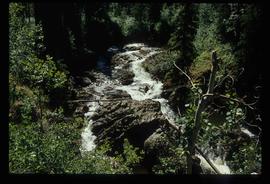
Mostrando 3113 resultados

Archival description
Miles Canyon - A River
2012.13.1.98.65 · Item · 1999
Parte de J. Kent Sedgwick fonds

Image depicts a river in the Miles Canyon near Whitehorse Y.T. The Robert Lowe Bridge, built in 1922, can be seen over the canyon.

A Bear
2012.13.1.98.71 · Item · 1999
Parte de J. Kent Sedgwick fonds

Image depicts a bear, possibly a grizzly. The location is uncertain.

Railway - Near Summit
2012.13.1.100.19 · Item · 1999
Parte de J. Kent Sedgwick fonds

Image depicts two merging railway tracks, and what appears to be a frozen river, somewhere near the summit of a mountain.

View Down to Skagway
2012.13.1.100.23 · Item · 1999
Parte de J. Kent Sedgwick fonds

Image depicts a view over a forested, mountainous area and a river towards the vicinity of Skagway, Alaska.

2012.13.1.89.136 · Item · 1999
Parte de J. Kent Sedgwick fonds

Image depicts four individuals sitting on a log, possibly somewhere near the Hansard Bridge, B.C. The individuals are UNBC faculty members Gail Fondahl, Tracey Summerville, Greg Halseth and an unidentified individual. The slide is labelled: "Hansard Bridge UNBC." Map coordinates 54°04'37.7"N 121°50'39.9"W

Road to Skagway
2012.13.1.98.01 · Item · 1999
Parte de J. Kent Sedgwick fonds

Image depicts the road to Skagway, Alaska. Possibly located on the Klondike Highway in British Columbia with Tutshi Lake on the left.

Atlin Lake
2012.13.1.98.14 · Item · 1999
Parte de J. Kent Sedgwick fonds

Image depicts Atlin Lake as well as a small section of Atlin, B.C. The mountain is possibly Atlin Mountain.

Forested Mountains
2012.13.1.100.06 · Item · 1999
Parte de J. Kent Sedgwick fonds

Image depicts a view of a forested, mountainous area and a river, somewhere along the White Pass railway. The slide is labelled "begin climb," suggesting the image was taken at the beginning of the White Pass Train's ascent into the mountains.

Stream
2012.13.1.100.07 · Item · 1999
Parte de J. Kent Sedgwick fonds

Image depicts a stream somewhere along the White Pass railway.

Forested Valley
2012.13.1.100.08 · Item · 1999
Parte de J. Kent Sedgwick fonds

Image depicts a view of a forested valley in the mountains somewhere along the White Pass railway.

Forest and River
2012.13.1.100.09 · Item · 1999
Parte de J. Kent Sedgwick fonds

Image depicts a view of a forest and river somewhere along the White Pass railway. The thin line in the mountain side is possibly a highway.

Another Train
2012.13.1.100.14 · Item · 1999
Parte de J. Kent Sedgwick fonds

Image depicts another train on the White Pass railway along a forested mountain side.

Tunnel
2012.13.1.100.15 · Item · 1999
Parte de J. Kent Sedgwick fonds

Image depicts the White Pass Train entering a tunnel in the mountain side.

Trail of 98
2012.13.1.100.20 · Item · 1999
Parte de J. Kent Sedgwick fonds

Image depicts a patch of snow-covered ground with a sign that reads "Trail of 98," somewhere along the White Pass railway.

Fire Place and Couch Snow Sculptures
2012.13.1.3.149 · Item · Apr. 1999
Parte de J. Kent Sedgwick fonds

Image depicts a snow sculpted fire place and couch on a skating rink, possibly during the Winter City Conference, in Prince George, B.C. Taken at the Prince George Civic Center. Map coordinates 53°54'45.6"N 122°44'59.6"W

Mr. P.G. on Couch Snow Sculpture
2012.13.1.3.150 · Item · Apr. 1999
Parte de J. Kent Sedgwick fonds

Image depicts a snow sculpture of the Mr. P.G. lounging on a couch, possibly during the Winter City Conference, in Prince George, B.C. Taken at the Prince George Civic Center. Map coordinates 53°54'45.6"N 122°44'59.6"W

Tsilcoh Falls
2012.13.1.51.147 · Item · 1999
Parte de J. Kent Sedgwick fonds

Image depicts the Tsilcoh Falls, north of Fort St. James and somewhere near Pinchi Lake Road.

A Cow
2012.13.1.89.168 · Item · 1999
Parte de J. Kent Sedgwick fonds

Image depicts a cow at an uncertain location.

Bear Snow Sculpture
2012.13.1.3.147 · Item · Apr. 1999
Parte de J. Kent Sedgwick fonds

Image depicts a snow sculpture of a bear, possibly during the Winter City Conference, in Prince George, B.C. Taken at the Prince George Civic Center. Map coordinates 53°54'45.6"N 122°44'59.6"W

Man with Shovel Snow Sculpture
2012.13.1.3.151 · Item · Apr. 1999
Parte de J. Kent Sedgwick fonds

Image depicts a snow sculpture of a man with a shovel, possibly during the Winter City Conference, in Prince George, B.C. Taken at the Prince George Civic Center. Map coordinates 53°54'45.6"N 122°44'59.6"W