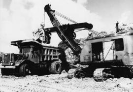
Photograph depicts crawler cable shovel, bucket over box of Kenworth truck in excavation area of mine. Handwritten annotation on verso of photograph: "1961".
Photograph depicts a large shelter over building believed to be power house. Electricity lines cross midground and run to power house. A man can be seen crossing the foreground by steel frame supplies, and a second building is partially visible on right. Mountains stand in background and a crane can be seen operating in front of power house. Handwritten annotation on verso of photograph: "1961".
Photograph depicts the diesel-fired burners of the ore dryers. The large pipes and valves above were part of the fuel supply system fed by Cassiar's fuel tank farm which also supplied the power house generators. The dryer section of the mill received ore from the crushing plant by tramline and truck. These burners blasted the ore with hot air, and dried ore to desired moisture content before it was sent to the dry rock storage building and stored for mill use. Handwritten annotation on verso of photograph: "1961".
Photograph depicts unidentified woman using Bauer Mcnett machine to test length of fibre samples by using water. Woman stands facing wall, away from photographer, unidentified equipment on either side.
Photograph depicts unidentified man lifting package of asbestos bags with forklift in large building. Truck in background, ready for loading.
Photograph depicts church building with what appears to be speakers mounted on roof above main entry. Trees in foreground and background. Handwritten annotation on recto of photograph: "All Saints Anglican Community Church".
Photograph depicts building containing Cassiar's bar and snackbar, visible across ball field. This building originally housed school classrooms, movie theater, barber shop, and rec centre with three pool tables. Private liquor store originally located in far right of building. Liquor store was known to be the only legal bootleg liquor business in the province at the time, before it was transferred to Cassiar's government liquor store and replaced with a Sear's office. Catholic church and other buildings are visible behind trees in right midground. Road and field in foreground, valley and mountains in background. Community Centre located behind photographer, out of frame, curling rink on photographer's right.
Photograph depicts men's ball game in foreground, spectators and cars visible behind backstop net. Bar and snackbar building in right midground, trees and mountain base in background. See item 2000.1.1.3.19.52 for information regarding bar and snackbar building.
Photograph depicts Hilde Voss (see item 2000.1.1.3.19.68) wearing white shirt, with unknown woman in snackbar. Counter and other individuals on left, cooking supplies in foreground. Interior window in background connected snackbar to poolroom. Eventually this snackbar was moved to poolroom, and liquor store located in original snackbar.
Photograph depicts group of twenty-four men standing on front steps of main office building. Handwritten annotations on recto of similar photograph: "OFFICE STEPS APPROX 1965 / TOP L-R / JULIEN ST. GEORGES / GEORGE TROWSDALE / HANS VELTMEYER / BOB LOVETT / KARL SHULTZ / LOTHAR TISCHLER / - "; "2ND / FRANK CLEMENTS [i.e Kliment?] / BILL PLUMB / HEWETT / - "; "3RD - / - / RENE PASIAUD / DICK [Stevens]"; "4TH / DOC NAVIN / VIC SARAKOSKI / - "; "5TH / CHARLIE GANDER / GORDON EDWARDS / AL FLANIGAN [i.e. Flanagan?] / ANDRE BEGUIN / CHARLIE BRONSON / JACK THORNICROFT". Information in above annotation supplemented with insight from individuals who contributed to Northern BC Archives Facebook Photo ID Project, contact archivist for more information in research file pertaining to this photograph.
Photograph depicts tramline buckets and tower on plantsite. Vehicles, building materials, and unidentified buildings also visible on plantsite (including what appears to be a water tower). Mountains and valley in background. Handwritten annotation on verso of photograph: "Cassiar June 15 71".
Photograph depicts two-story yellow and orange office building. Unidentified individual stands with garden hose in foreground near what appears to be a lawnmower. Warehouse semi-visible in left background; blue truck and new mill building visible in right background. Handwritten annotation on verso of photograph: "Cassiar Office June 15 71".
Photograph depicts two unidentified men on front deck of building behind trees. Road and car in foreground, mountains visible in background. Handwritten annotation on verso of photograph: "Directors Lodge Cassiar June 15 71". Building also known as "House 130".
Photograph depicts brown and white building similar to the "Director's Lodge" at Cassiar, B.C. (see items 2000.1.1.3.19.88 and 2000.1.1.3.19.89). Station wagon parked in driveway behind short fence in foreground. Trees in foreground, forest and mountains visible in background. Handwritten annotation on verso of photograph: "Cassiar June 15 71".
Photograph depicts two unidentified men in front of yellow and red helicopter at unknown location. Power lines and trees in background. It is possible that this photo may have been taken at Clinton Creek, Y.T. rather than Cassiar, B.C.
Photograph depicts the West Peak of the Cassiar mine on McDame Mountain. Pit area visible between West Peak and road in foreground. Mine valley and north mountain range in background. Photo speculated to have been taken from a point on or near the South or North Peak.
Photograph depicts mine valley and road in foreground. Cassiar plant and tailings pile visible in left midground, townsite in right midground. Mountainside of McDame Mountain in foreground, southern mountain range in background.
Photograph depicts two unidentified men entering building with the sign "THE ROYAL BANK OF CANADA" above main entrance. Photographer with tripod in foreground.
Photograph depicts row of houses behind trees. Road, front yards, and vehicle in foreground, mountains in background.
Photograph depicts line of men across serving counter in building believed to be cafeteria. Two unknown employees dishing food in left foreground.
Photograph depicts men and women seated in red and yellow chairs at tables. Windows and curtains visible in right background. Sign hanging in left background reads: "DINNING ROOM MUST BE VACATED [10?] MIN. AFTER CLOSING TIME POSTED".
Photograph depicts long building with blue siding. Security was located at corner of building in centre foreground, behind stop sign. Single red door on left was main entrance into mine dry, where individuals were checked through security. Two larger windows on left indicate the location of the mine store where work apparel could be purchased. Building also housed change house (see item 2000.1.1.3.19.121) and offices of the mine department supervisory staff. Employee parking lot located out of frame to right. Mill building stands in background, tramline dump station on left. Ore car visible, about to enter dump station. Unidentified man and child can be seen in foreground.
Photograph depicts woman wearing safety gear in second floor of mill building, holding unidentified instruments. Helen Joseph took air quality tests in the working areas and town (see item 2000.1.1.3.19.147).
Photograph depicts mobile home modified for Cassiar winters (steeply sloped roof added). Yellow suburban parked in driveway in left foreground. Forest trees and mountainside visible in background. Sign reading "686" posted on tree in left foreground. Believed to be the home of Gerry Cooper.
Photograph depicts a truck on a newly cleared dirt road in a mountain pass and a wooded area.
Photograph depicts a wooden structure in a gravel landscape. Truck with open door in foreground, forest and snow capped mountains in background. Mounds of gravel visible behind structure.
Photograph depicts the wooded area of the Cassiar valley. The projected plant site is outlined in blue ink. Trees and bushes in foreground, snow-capped mountains in background.
Photograph depicts approximately six lumber piles in the northwest corner of snow-covered plant site. Forest and snow-capped mountains in background. Photo taken facing west.
Photograph depicts tent structures among trees at the temporary Cassiar construction camp. Taken from future site of garage building, looking northwest, snow-capped mountain in background.
Photograph depicts three men building garage foundation in snow-covered plant site. Truck to right of men, wood fence structure in foreground, Asbestos Valley in background.
Photograph depicts Cassiar's Chief Geologist Bill Plumb and unidentified man standing on shore by yellow Cassiar supervisor's truck. Airplane is parked on lake behind them, and miscellaneous equipment lies on shore at Bill's feet. Photograph speculated to have been taken at Aeroplane Lake, approximately 35 miles east of Cassiar. Bill Plumb led many expeditions for the purposes of Cassiar's outside exploration endeavours.
Photograph depicts a geologist's hammer, believed to belong to Cassiar's Chief Geologist Bill Plumb. The hammer provides a scale for the exposed asbestos, indicating the percent of fibre in the rock as well as the expectation of grade.
Photograph depicts top of framed building, mountain in background.
Photograph depicts dump truck on hill believed to be in mine area, unknown structure on left.
Photograph depicts tarp-covered truck, two men on right, mountains in background.
Photograph depicts bridge crossing river, trees in background.
Photographs depict electrical room.
Photograph depicts bridge in snow landscape, trees in background. Corresponding note on accompanying photo description page: "March 29th: 2. Timber bridge at the Blue River."
Photograph depicts bunkhouse under construction in wooded area, men in foreground. Corresponding note on accompanying photo description page: "April 7th: 5. Erecting the walls for # 1 Bunkhouse. Looking east."
Photograph depicts snow-cleared dirt area, trees in background. Corresponding note on accompanying photo description page: "April 7th: 10. Site for townsite well cleared and started excavating."
Photographs depict electrical room.
Photograph depicts electrical panel, dark figure or shadow on left. Corresponding note on accompanying photo description page: "Feb. 23rd: 8. Panel board in Power House."
Photograph depicts road in mine valley. Rectangular black shadow in foreground on right, mountains in background.
Photograph depicts four men standing in doorway of log shelter built into mountainside. Men standing in path leading to doorway, snow at elbow height on either side. Shelter is speculated to be a portal to a mine adit.
Photograph depicts plant site, two mountains in background. Power poles, box, and piles of unidentified material in foreground. Speculated corresponding annotation on verso of page stapled to photograph: "Cassiar Hills (Midday in December)".
Photograph depicts diesel engine and alternator in room, electrical board on right. Typed annotation taped to verso of page stapled to photograph: "300 K.W. Ruston Hornsby diesel and alternator in power house."
Photograph depicts an ore gravity chute on McDame Mountain. Corresponding note on accompanying photo description page: "August 5th: 12. Ore chute down mountain slope." Typed annotation taped to verso of page stapled to photograph: "View looking down portion of chute."
Photograph depicts mountains, half covered in shadow. Power poles and power house in foreground, piles of unidentified material on right. Speculated corresponding annotation on verso of page stapled to photograph: "Cassiar Hills (Midday in December)".
Photograph depicts eight men in snow around unidentified object, speculated to be portion of glacier. Speculated corresponding annotation on verso of page stapled to photograph: "Overturned Tanker (Glacier 1 mile north of Joe Reed's)".