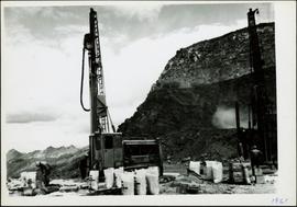
Photograph depicts man driving bulldozer in front of framework for Crusher building, view facing into the mountain. Excavated dirt in foreground.
Photograph depicts four construction workers in front of tall wood structure extending to top level of construction area. Building material and supplies cover the ground: lumber, saw horses etc. Barricades against loose rock enclose area in midground (see item 2000.1.1.2.352). Plastic-covered pile sits at top level in background.
Handwritten annotation on recto of photograph: "RETAINING RIBS JUNE 29/64". Photograph depicts construction workers on and near wooden framework structure extending from base of crusher building. Crane in background against mountainside. Miscellaneous construction equipment and materials throughout.
Photograph depicts the Cassiar townsite behind shadow in foreground. Plantsite can be seen including the mill, dry rock storage building, tailings pile, and many other buildings. Mountains in background. Handwritten annotation on recto: "<- 13 1/2" ->". (This photograph was made into a promotional poster.)
Photograph depicts the North peak of McDame mountain after extensive strip mining, South peak unmined in background. Old mine garage visible on right of West peak in foreground. Crusher plant partially visible on far right. Photograph believed to have been taken just prior to the development of the pit mine between the North and West peak.
Photograph depicts the Cassiar valley: town on left, plant on right, mine valley in background. Photograph was taken from above, facing north east.
Photograph depicts the Cassiar plantsite behind tailings pile in foreground. Mine road runs north though valley bellow mine, strip mining barely visible in background. Photograph was taken from above, facing north.
Photograph depicts the Cassiar valley: town in left foreground, plant and tailings pile in midground, mountains in background. Photograph was taken from the air, portion of plane visible in top left of image.
Photograph depicts the Cassiar valley: town on left, plant and tailings pile on right, mountains in background. Mine road can be seen from plant to mine valley in top left of image.
Photograph depicts the town of Cassiar, mountain base in background. Mine road visible in top right of image.
Photograph depicts the town of Cassiar, mountain base in background.
Photograph depicts the town of Cassiar in foreground, mountain base in background. Photograph was taken from the air, portion of plane visible in top left of image.
Photograph depicts the Cassiar mine above valley bellow, north east mountain range in background. Photograph was taken from the air, portion of plane visible in top left of image.
Photograph depicts the mine valley in foreground below Cassiar Mine, north east mountain range in background.
Photograph depicts the West peak of the Cassiar mine, pit partially visible below. Mining equipment barely visible in foreground at highest elevation of mine, north west mountain range stands in background, and mine valley crosses midground.
Photograph depicts the Cassiar valley: plant and tailings pile in left foreground, west end of town in right foreground. South mountain range stands in background.
Photograph depicts the Cassiar mine, pit partially visible behind West peak in right centre of image. South west mountain range in background.
Photograph depicts the Cassiar mine, crusher plant visible in centre foreground in front of West peak. North east mountain range in background.
Photograph depicts a portion of the pit in foreground at the Cassiar mine. Crushing plant visible in centre below base of West peak. Footwall road in midground, mine valley in background. Building near trucks at top of pit was called the "shifter shack," where crews were relieved or dropped off for work.
Photograph depicts a portion of the Cassiar pit in right foreground. Crushing plant visible to left of pit, West peak visible in right background. Mountain range can be seen in distance.
Photograph depicts benches after strip mining at Cassiar. Drill visible in distance, ore haul trucks on road in foreground.
Handwritten annotation on recto of photograph: "ASBESTOS FIBRE VEINS AS THEY OCCURR IN A ROCK FACE". Photo caption under printed copy of image in 1952 Annual Report: "North Wall of adit approximately 225 feet from portal showing asbestos veinlets."
Photograph depicts exposed asbestos fibre in talus.
Image of man seated with shovel in mountainous area, loose asbestos fibre in background. This photograph is believed to be either a double exposure of two images, or a print made from two negatives at once. Photo depicts an unidentified man sitting on the south ridge of the Cassiar ore body, where the crusher and rock reject plant would eventually sit. Valley in background appears to depict the "Footwall Road," which was cut into the mountain from the pit to the crusher plant and became the mine's main haul road.
Photograph depicts exposed asbestos fibre in talus below outcrop. Handwritten annotation on verso of photograph: "Sept 1954."
Photograph depicts buildings near West Peak of Cassiar mine. Haul trucks parked near old mine garage in background, new mine garage and unknown buildings in foreground. Mine valley crosses midground, expansive western mountain range in background.
Photograph depicts benches from strip mining operations at the Cassiar mine. Haul trucks and equipment believed to be used for explosive purposes can be seen in mine. Shop and mountain range visible in background. Handwritten annotation on recto of photograph: "Cassiar, BC / June 1970 / by Tom Kiefer". Image consists of three photographic prints adhered together to form one comprehensive panoramic.
Photograph depicts colour-coded model of mine in display case. Legend partially legible in image: "TALUS / VOLCANICS / WASTE SERPENTINE / AAA ORE / AA ORE". Handwritten annotation on recto of photograph: "Cassiar B.C. June 1970 by Tom Kiefer".
Photograph depicts chute from distance. Annotation on verso of photograph: "CASSIAR ASBESTOS CORP. LTD. MINE AND ORE CHUTE ON McDAMES MOUNTAIN".
Photograph depicts large dry rock storage building on left, mill in background, dryer building on far right. Road and power poles cross foreground, mountains stand in background. Photo caption next to printed copy of image in 1953 Annual Report: "Completed dry rock storage and dryer buildings."
Photograph depicts an unidentified man standing to left of large puddle in gravel pit, mountain peaks in background. Photo speculated to have been taken on the plant, or near the Cassiar airstrip, facing south west. Stamped annotation on recto of photograph: "JUN. 1987".
Photograph depicts yellow conveyor belt in foreground over gravel pit, dump truck behind in midground. Mountains visible in background. Photo speculated to have been taken at the plant or near the Cassiar airstrip. Stamped annotation on recto of photograph: "JUN. 1987".
Photograph depicts mine area at Cassiar, crushing plant visible on left. Various mine buildings visible midground. Blasthole drills, shovels, dozers, and dump trucks can be seen on bench in foreground at 6430 elevation. Handwritten annotations on recto of photograph: "6"; "View looking NW from top of S. peak 6790 elev. on 6430 stripping bench on it and 6050 ore bench further down on left."; "July 1961".
Photograph depicts men standing near two Atlas Copco Drillmasters (blasthole drills). These are precision hammer drills which had their own power source. Large bags of ammonium nitrate in foreground, mountainside in background. The men depicted here were likely members of the explosive crew. It is believed that this photo was taken on the North ridge, near the cirque dump. Handwritten annotation on verso of photograph: "1961".
Photograph depicts a man wearing a hard hat preparing long narrow bags of explosive material. Large bags of ammonium nitrate in right foreground, mountains in background. Handwritten annotation on verso of photograph: "1961".
Photograph depicts crawler cable shovel and dump truck in excavation area of mine. Handwritten annotation on verso of photograph: "1961".
Photograph depicts a Chevrolet pickup truck on highway to right of Mud Lake, at Km 632 on the Stewart-Cassiar Highway. Forest on hillside in background.
Photograph depicts palletizer machinery, where bags of asbestos fibre were shrink-wrapped and made ready for shipping pallets. Palletizer was located near shipping (believed to be in mill building). Unidentified man visible in machinery on far left.
Photograph depicts mountain side mostly covered in snow. Corresponding note on accompanying photo description page: "10. Snow on mountain slope above road between where mountain road starts and the first switchback. This snow will melt and the water must still pass over or along road."
Photograph depicts high snow bank on right, side of tractor plow on left. Mountainside in background. Corresponding note on accompanying photo description page: "3. Plowing snow on road to mine. This location is just past the Upper Camp. Our TD-14 tractor to left."
Photograph depicts snowy, cleared area bordered by dirt piles. Stakes visible in mid ground, trees and mountainside in background. Corresponding note on accompanying photo description page: "3. Survey stakes on power house site. Snow piles in background."
Photograph depicts Joseph wearing safety gear while standing at testing equipment on raised sampling station. Sign below Joseph reads "DO NOT DISTURB / SAMPLING IN PROGRESS / PROPERTY OF ENVIRONMENTAL CONTROL DEPT. / CASSIAR ASBESTOS LTD." Helen Joseph took air quality tests in the working areas and town (see item 2000.1.1.3.19.135). Power lines, unidentified building, and mountain base visible in background. Photo was taken during winter.
Photograph depicts three men with fishing gear. Trees and mountains in background. Left to right: Plato Malezemoff (holding fish), Jack Christian, Tam Zimmermann.