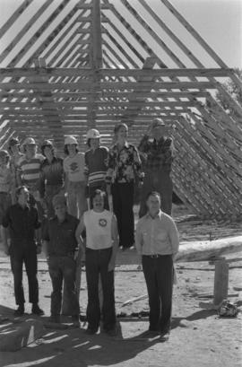
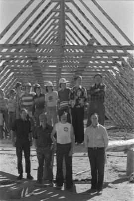
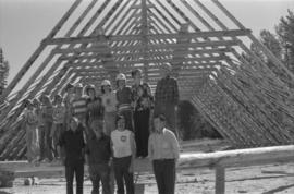
The photograph depicts seven men and women on the railway turntable at the CN Railyard in Prince George, B.C. Reproduction of photograph from 1984.
Image depicts a group of individuals standing on the corner of 3rd Ave in Prince George, B.C.
Photograph depicts a group portrait of Iona Campagnolo with construction workers at a building site, possibly for a Young Canada Works project.
Photograph depicts a group portrait of Iona Campagnolo with construction workers laughing at a building site, possibly for a Young Canada Works project.
Image depicts the Grand Trunk Pacific railway roundhouse in Prince George, B.C.
File contains slides depicting images of the Grand Trunk Pacific railway roundhouse in Prince George, B.C.
Image depicts the Grand Trunk Pacific railway roundhouse in Prince George, B.C.
Image depicts the GTP roundhouse in Prince George, B.C.
Image depicts the Grand Trunk Pacific railway roundhouse in Prince George, B.C.
Image depicts the interior of the GTP roundhouse in Prince George, B.C.
Image depicts machinery in the GTP roundhouse in Prince George, B.C.
The photograph depicts the Grand Trunk Pacific Railyard roundhouse and water tower in Prince George, B. C. Reverse side of photograph states, "Photo Credit: Fort George Museum." Reproduction from [192-?].
The item is a photograph of Gundy's News and an empty commercial building on 3rd Avenue in Prince George.
The item is a photograph depicting the exterior view of the front of Gundy's News Supply Ltd. at 1244 3rd Avenue, Prince George. Part of the Columbus Hotel and Pub at 1250 3rd Avenue and a vacant building at 1232 3rd Avenue can be seen. There is a woman standing outside one of the businesses. Photograph originally taken between 1978 and 1979.
The item is a photograph of the H&R Block building and an empty commercial building on 3rd Avenue in Prince George.
Image depicts a bridge in Hagwilget, B.C.
Image depicts a church on a hill in Hagwilget, B.C.
Close view of bridge built with wooden planks, poles, and wires, braced from below, with triangles built into its frame. The bridge crosses Hagwilget Canyon on the Bulkley River, five kilometres from its confluence with the Skeena River. This is one of the many bridge structures that have crossed this location since at least 1859. Photograph was taken from one side of canyon, near bridge. Opposite canyon wall in background. Typed annotation glued to verso of photograph: "HAGWILGET - 'the gentle or quiet people'."
Photograph depicts two men and a horse on a bridge built with wooden planks, poles, and wires, braced from below, with triangles built into its frame. The bridge crosses Hagwilget Canyon on the Bulkley River, five kilometres from its confluence with the Skeena River. This is one of the many bridge structures that have crossed this location since at least 1859. Photograph was taken from a distance. Rocky riverbank in foreground, opposite shore in background behind bridge. Typed annotation in red ink on verso of photograph: "INDIAN BRIDGE, NEAR HAZELTON, B.C."
Photograph depicts bridge built with wooden planks and poles, braced from below, with triangles built into its frame. The bridge crosses Hagwilget Canyon on the Bulkley River, five kilometres from its confluence with the Skeena River. This is one of the many bridge structures that have crossed this location since at least 1859.
Handwritten annotation on recto of photograph: "old bridge at the Bulkley River."
Photograph depicts the wooden Hagwilget Bridge spanning a rocky gorge over the Bulkley River. Forested area visible in the background. Annotation on recto of photograph states: "W.W.W. Old Indian Bridge, Bulkley River"
Photograph of the dirt road leading to Hagwilget Village. Residential buildings and a church are visible in the background. Printed annotation on recto reads: "W.W.W. Hagwilget Village."
Photograph depicts an unidentified individual leaning against a large overturned dugout canoe; barrel, bucket, and wood planks in foreground. Houses and other buildings can be seen on shore above beach, and two unidentified individuals stand in distance on far right.
Handwritten annotations on verso read: “Haida canoe on beach at Masset / ? 1898”; “No. 4 Page 5. Haida Canoe ready for steaming to [widen?] out and finish.”
An original negative of this photograph is held by the Canadian Museum of Civilization, no. 26664.
File contains slides depicting places on Haida Gwaii, formerly known as the Queen Charlotte Islands.
Handwritten annotation on verso of photograph reads: "No. 54. Old tombs & totems. / to Haida graves Massett".
Two tombs stand in foreground, each consisting of a horizontal box held by two hollow posts sunk in the ground.
Handwritten annotation on verso of photograph reads: "Tombs. ? Massett".
Caption under printed version of photo in W.H. Collison's book 'In the Wake of the War Canoe': "At Masset, Queen Charlotte Islands, B.C. The side-posts are solid and sunk in the ground. The horizontal piece is hollow, and contains the corpse. These tombs are now falling through decay." (see page 216).
Image depicts an old, half-collapsed building at an uncertain location.
Image depicts a house on Blackwater Road.
Image depicts a hallway in an unknown building somewhere in Wells, B.C.
The photograph depicts a hallway with windows at the interior of the CN roundhouse in Prince George, BC. Reproduction of photograph from 1984.
View of 5 buildings and 4 tents on land that has been cleared to stumps. Printed annotation on verso reads: “HAMILTON AVE. FORT GEORGE”, added handwritten annotation in ink reads: “1910”.
Street scene showing people, dog, team of horses & wagon. Signage reads: “Beds; Mecca Café; Hardware.” Printed annotation on recto reads: “Hamilton Avenue, South Fort George, B. C. No. 110.” Verso displays cancelled 1 cent Canadian Postage Stamp and handwritten message in ink is addressed to Mr. Eathan Villard Burt Mish, U.S.A.
Photograph depicts Hamilton St. in Vancouver, looking northeast.
Image depicts a man and woman shaking hands in a building at an uncertain location, possibly in Cottonwood Park. The man standing behind the two is possibly Elmer Mercier, a former mayor of Prince George, B.C.
Photograph depicts a building that was believed to have had many usess, its last being a fish store.
Image depicts the new Hansard Bridge. Map coordinates 54°04'57.9"N 121°51'10.1"W
Image depicts the Hansard railroad bridge taken from the new Hansard vehicle bridge. Map coordinates 54°04'58.1"N 121°50'58.0"W
Image depicts the Hansard railroad bridge looking west. Map coordinates 54°04'37.9"N 121°50'46.3"W
View of building, dock, harbour and small islands with snow peaked mountains in background. Printed caption on verso reads: “Port Essington B.C. Photo by P. E. Fisher”. Handwritten annotation in ink on verso reads: “up the Skeena”, in pencil on verso: “Port Essington, North Coast Commercial Coy”.
Boats, docks, ships and a large building in waterscape. Printed annotation on recto reads: “Prince Rupert B.C.” Handwritten annotation in pencil on verso reads: “McRae Bros”.
Elevated view of the buildings along the Prince Rupert shore, including the Prince Rupert Inn. The waterfront and some small islands can be seen in the background. Printed annotation on recto reads: "Harbour, Prince Rupert, B.C. 1658."
File consists of clippings, notes, and reproductions relating to the house of Harry G. Perry, a politician and founding community member of Prince George. Includes: "Heritage site inventory" typescript document (1988); "Heritage advisory committee minutes" reproduction of a typescript document (13 Nov. 1980); "Application to rezone lots" typescript document from the City of Prince George (3 Mar. 1982); "By-law No. 3631" typescript document from the City of Prince George (24 Nov. 1980); "Minutes" typescript document from the Prince George and Fraser-Fort George Regional District Heritage Advisory Committee (13 Nov. 1980); "The Carter House" typescript letter from the Heritage Advisory Committee to the City of Prince George (21 Sept. 1979); and "RE: Status Report" typescript document from the City of Prince George to the Joint Heritage Committee (9 Sept. 1980). Also includes architectural drawings depicting plans for building the Carter house at 1850 Tenth Ave, Prince George (1979).
Image depicts Glenview Drive near the Hart Highway in Prince George, B.C.