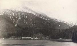
Photograph depicts a cannery in front of a forested mountains with water in the foreground.
Photograph depicts a man in a fishing boat in front of a line of fishing boats being towed by a tug boat on the water with the base of a mountain in the background.
Plan depicts Granville Island industrial sites in False Creek, Vancouver. Shows revised trackage from 1955 annotated in colour by Davies.
Image depicts a sawmill somewhere in Quesnel, B.C.
Image depicts numerous wood piles near the sawmill somewhere in Quesnel, B.C.
The item is a CD-R containing Kent Sedgewick's files regarding the Upper Fraser Valley history. Files include literature summaries, oral history transcripts and various other documents referring to the Upper Fraser Valley. Annotations on CD-R state, "Jun 7 '04 Kent - UF files to start."
The map depicts mineral deposits in Northern British Columbia.
The map depicts the distribution locations and transportation routes for the processing of mineral and petroleum in British Columbia.
The map depicts where minerals can be found and also includes railways, highways, and roadways for easy access to desired minerals.