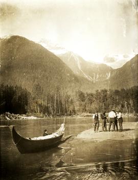
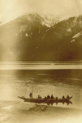
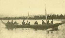
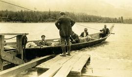
Five unidentified men sit with dog in canoe. One man stands on dock in foreground.
Handwritten annotation on verso reads: "Freighting by canoe on skeena river".
Five unidentified men sit with dog in canoe. One man stands on dock in foreground.
Handwritten annotation on verso reads: "Freighting by canoe on skeena river".
Photograph depicts three men standing with oars in small boat, forest slash at their feet. More slash lies in foreground behind bushes and plants on swampy shore. Trees in background. These men are believed to be members of the Bourchier forestry crew.
Photograph depicts men walking and standing on pier over water in unidentified area. A large pile of bundles can be seen on pier. Large buildings stand on shore, and trees cover hillside in background. Portion of a boat or ship tethered to shore is partially visible in right foreground.
Photograph depicts group of men walking on what appears to be a dirt road near open field. A parked plane is visible in distance, forest trees in background.
Photograph depicts pipeline construction workers for the Pacific Northern Gas pipeline from Summit Lake to Kitimat with a helicopter on the north end of Prudhomme Lake.
Photograph depicts a compressed air locomotive that was built in 1901 for Michel underground coal mine work. It was removed from workings in 1965.
Photograph depicts a compressed air locomotive that was built in 1901 for Michel underground coal mine work. It was removed from workings in 1965 and was purchased by the present owner as an exhibit.
File consists of a publication by Jim Hope and Donald Bain entitled "Memories of Canadian Pacific Steam Power in British Columbia".
Photograph depicts four men standing in front of small log cabin with sod roof. It is believed that these men are also featured at Ah Yee's in item 2009.5.3.16. A man believed to be Meikle sits in window of cabin. Forest in background. Handwritten annotation on recto of this photograph reads: "Meikle's Cabin mouth of Clearwater".
Photograph depicts a mechanical side cutting machine at the C.P.R. Coquitlam yards.
Photograph depicts a tiny switcher that belonged to the McLean sawmill and was buily by Buda of New Westminster, circa 1927. Sat on unconnected trackage adjacent to the Alberni Pacific Railway and was part of a sawmill exhibit.
Image depicts a red vehicle parked on the side of the road with a view of the McGregor Valley behind it. The slide is labelled "dam site."
Image depicts a bridge over the McGregor River. A sign in the image reads: "Danger. The river is not navigable for any type of boat. Down stream falls and rapids impassible!"
Image depicts a bridge over the McGregor River.
Photograph depicts the McCulloch CPR depot at mile 76.6 on the Carmi Subdivision. The depot was painted blue inside. The last passenger train was seen 17 January 1964 and the last freight train on the 19 May 1973.
Photograph depicts the McCulloch CPR depot located at mile 76.7 on the Carmi Subdivision, which is about 27 miles northeast of Penticton. The rear building is the passenger depot, which was painted blue inside. The view is looking north.
Photograph depicts the McCulloch CPR depot located at mile 76.7 on the Carmi Subdivision, which is about 27 miles northeast of Penticton. The building on the right is the passenger depot, which was last officially used in January 1964. The view is looking south on the downgrade.
Photograph depicts the McCulloch CPR depot located at mile 76.6 on the Carmi Subdivision., about 27 miles northeast of Penticton. The lifted switch at the right leads to a former "Y" that led east. The view is looking north.
Photograph depicts street in McBride, wood buildings and tent buildings on either side. Small businesses and restaurants line the left side of the street. Forest slash stands in newly cleared area in foreground. Railway tracks cross right foreground, hills visible in background. Annotation on verso of photograph reads: "MC.Bride, B.C.", handwritten on recto: "1914 [Bourchier?]"
Image depicts the McBride CNR station.
Image depicts the rear-end of the CN Station in McBride, B.C.
Image depicts the CN Station in McBride, B.C.
Photograph depicts Mayo Lumber Co. locomotive # 3 on display at Paldy, in central Vancouver Island.
Photograph depicts Mayo Lumber Co. 2 truck Shay locomotive # 3 on display at Paldy, between Duncan and Lake Cowichan, B.C.
Photograph depicts Mayo Lumber Co. locomotive # 3 on display at Paldy, between Duncan and Lake Cowichan, B.C.
Photograph depicts Mayo Lumber Co. Shay locomotive # 3 on display at Paldy, between Duncan and Lake Cowichan, B.C.
Typed annotation on verso reads: "Matt Caldwell on GTP/CNR turntable at Endako c. 1950. Pre-WW1, Matt worked as boiler maker for Grand Trunk in Montreal & later in Edson. He served in WW ! with First Pioneers from P.G. and after the war became (eventually) Loco Foreman in Endako: retired c. 1950. Photo: May Caldwell Dockrill (daughter) & "Deeper Roots & Greener Valleys", published by Fraser Lake & District Historical Society."
Photograph depicts man standing in CNR / GTP roundhouse at Endako. Typed annotation on verso reads: " Matt Caldwell in CNR/GTP roundhouse at Endako, pre-1950. Pre-WW1, Matt worked for Grand Trunk in Montreal as a boiler maker, moving to GTP in Edson. Served in WW1 with First Pioneers from P.G. Eventually promoted to Loco Foreman in Endako: retired c. 1950. Photo: May Caldwell Dockrill (daughter) & "Deeper Roots & Greener Valleys", published by Fraser Lake & District Historical society."
Photograph depicts a "Master" tug after it underwent restoration in False Creek, Vancouver. It was under steam, and entering English Bay.
Photograph depicts one of the two Mars flying boats that were used as water bombers. Either "Hawaii Mars' or "Phillippine Mars."
Group of five unidentified men stand on shore to right of large dugout canoe, handling their rifles. Forest and snow-capped mountains stand on opposite shore in background.
Handwritten annotation on verso reads: "Mrs Collison (wife of Arch. Collison in Canoe en route to Hazelton B.C."
Canoe with mast floats close to shore in foreground, mountains visible across river in background.
Handwritten annotation on verso reads: "Arch. W.H. Collison & wife with native friends en route up Skeena River."
Handwritten annotations read: "At rest, after a rough passage of two days and a night from Massett, Queen Charlotte's Islands by canoe - W.H. Collison and Mrs. Collison with Indians from Masset"; "Archdeacon Collison Indian Canoe & Crew. Return from Queen Charlotte's Islands, Haida & Tsimshian Crew [...?]" Archdeacon and Mrs. Collison sit in centre of canoe.
Margaret and Gus Lund stand on road, arms linked. Wood structure believed to be the box of a truck stands behind them on left. Power poles and forest in background behind road.
Photograph depicts Margaret Hope, organizer of a 3 week tour. She was standing beside her husband's deluxe machine that was built from scratch. Taken on the CNR Okanagan line.
File consists of notes and reproductions relating to Marcus Smith. Marcus Smith was a railway surveyor and in 1872 he was appointed as deputy to the Engineer-in-Chief of the Canadian Pacific Railway and took charge of British Columbia surveys between 1876-78. He worked as a surveyor for the CPR until 1886.
Subseries contains maps and technical drawings produced by Canadian National Railways. Predominantly consists of record plans of the B.C. Mountain Region. Also includes technical drawings of CN railway equipment.
Subseries contains maps and technical drawings produced Pacific Great Eastern Railways. Predominantly consists of plans of the rail line in the B.C. area. Also includes technical drawings of Pacific Great Eastern Railway structures.
Subseries contains maps and technical drawings produced by Grand Trunk and Grand Trunk Pacific Railways. Predominantly consists of plans of the rail line in the BC area. Also includes technical drawings of Grand Trunk Railway structures.
Subseries contains maps and plans depicting railway sites in British Columbia and the Yukon.
Map depicts the routes of the Pacific Great Eastern Railway, showing stations, railway connection, and the PGE Microwave Communication System.
Map depicts rail lines in the BC lower mainland, including BC Hydro Railway, Burlington Northern Railway, the Canadian Pacific Railway, the Canadian National Railway, and the Pacific Great Eastern Railway.
Film begins with short introduction of girl pointing to a map and drawing a line to where the men will be hunting.
Footage from a small plane overlooking the landscape of what is believed to be either the Bella Coola Valley, Tweedsmuir Provincial Park, Rainbow Mountains, or Chilcotin area.
Footage of hunting party setting up camp in the high country of the mountains. There is a herd of caribou and footage of caribou trophy kill. There is filming of two marmots and additional recordings of camp cooking and socializing.
The film ends with the hunters entering the plane again and returning to their original camp, believed to be Nimpo lake.
Photograph of the Prince Rupert wharf. Many vessels are docked next to small buildings along the water. Annotation on recto reads: "Prince Rupert BC."
File consists of documentary photographs taken by David Davies of manual maintenance of way vehicles in British Columbia.
Image depicts the road to Manson Creek, B.C.