Photograph depicts a woman, man and young girl believed to be A. K. Bourchier's niece Jean, standing on front balcony of house.
The group stands and sits with dog on front steps of house with veranda. Handwritten annotation on recto of photograph: "The whole 'Blamed Family'" (see also item 2009.5.2.267 for reference to Blamey family). Handwritten annotation on recto of duplicate: "All of us the same day, across the top Shirley Ed (Dorothy's husband) & Dorothy. Taken in front of their home."
Two couples stand by front steps of house with veranda. Handwritten annotation on recto of photograph: " Ed, Dorothy, Shirley, Rich. When Rich was home this summer."
This item is a photograph of the Fane Building in downtown Prince George. "For Lease Office Space" sign in one of the windows.
This item is a photograph of the Fane Building in downtown Prince George.
This item is a photograph of the Fane Building in downtown Prince George. The Telus building can be seen in the background.
Image depicts a farm likely in Woodpecker, B.C.
Image depicts a farm at an uncertain location.
Image depicts what appears to be a farm at an uncertain location.
Image depicts a farm likely in Woodpecker, B.C.
Image depicts a farm at an uncertain location.
Image depicts a farm at an uncertain location; possibly somewhere in the McGregor Valley.
Image depicts a farm at an unknown location.
The item is a photograph depicting an old white farm building. There is a covered area with various vehicles parked underneath. The photograph was taken from a road.
The item is a black and white photograph depicting a covered farm building with a car parked in one stall.
Photograph depicts two horses in one of many fenced areas, buildings and machinery in background. Highway, house, and forest also visible in distance.
Image depicts a farmhouse on Old Summit Road in Prince George, B.C.
Photograph depicts a house and barns on River Rd. in Surrey, 1 mile east of Deas Island Tunnel.
The item is a photograph depicting a white farmhouse off the Cariboo Highway.
The item is a 35 mm slide photograph depicting a white farmhouse off the Cariboo Highway.
The item is a 35 mm photograph depicting a farmhouse on the Cariboo Highway.
The item is a photograph depicting a farmhouse on Zilkie Road, Prince George.
The item is a 35 mm photograph depicting a farmhouse on Zilkie Road, Prince George.
The item is a photograph of the Prince George Federal Government Building, commonly referred to as the 'old post office.' The photograph depicts the exterior west wall of the building. Building was previously located at 1239 3rd Avenue, Prince George.
The item is a photograph of the Prince George Federal Government Building, commonly referred to as the 'old post office.' It has the Canadian coat of arms and "Prince George" above the main door. Annotation on the back states, "c. 1990." Building was previously located at 1239 3rd Avenue, Prince George.
The item is a photograph of the Prince George Federal Government Building, commonly referred to as the 'old post office.' The photograph depicts the exterior west wall of the building. Building was previously located at 1239 3rd Avenue, Prince George.
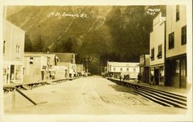
File consists of notes, clippings, and reproductions relating to federal government buildings in Prince George. Includes: "Fw: Info - Prince George Former Post Office - 1294 3rd Avenue" printed email from Trelle Morrow to Kent Sedgwick (27 May 2011); "City of Prince George" typescript letter to Noel O'Beirne from Kent Sedgwick (13 Nov. 1991); "Possible users for federal government building 3rd Avenue/Quebec Street" typescript letter to Alderman Becott from Kent Sedgwick (10 Oct. 1989); "City of Prince George" typescript letter to Dr. Colin Campbell, Director of Heritage Conservation Branch from Kent Sedgwick (5 May 1989); "RE: Municipal Heritage Designation of Federal Government Building" typed letter from Ian Whitbread to Kent Sedgwick (28 Mar. 1991); "Bylaw No. 5538" typescript document from the City of Prince George (3 Apr. 1991); "Public Notice 'Heritage Designation Bylaw No. 5538, 1990'" typescript document from B.C. Williams, City Clerk (1990); "Intersect" typed letter to Kent Sedgwick from Kathy Antonyk (14 Mar. 1994); and "Heritage Conservation in your community..". pamphlet from the Heritage Advisory Committee (1994). Also includes a photograph depicting the old Post Office in Prince George (1990).
Photograph depicts logs lying in brush in foreground, unidentified structures in background (possibly a tent)?
Image depicts a fence, perhaps somewhere in the Chilcotin region.
Image depicts a fence in the Blackwater River area in the Chilcotin.
Image depicts a fence somewhere in Anahim Lake, B.C.
Image depicts a wooden fence at an uncertain location, perhaps somewhere in the Chilcotin region.
Image depicts a wooden fence at somewhere in Meldrum Creek, B.C.
Image depicts a fence and power lines near the shore on Haida Gwaii. It is possibly a small community such as Masset.
Photograph depicts a fence at Nicola village, 7 miles northeast of Merritt.
File contains slides depicting images of fences and various other forms of log construction, ranging from 1970 to 1985.
Photograph depicts the Fernie CPR station, located at mile 34.7 on the Cranbrook Subdivision, which runs from Crowsnest to Cranbrook. In coal mining days this was a busy place but now it has sidings for 153 cars and nothing else. The view is looking east.
Image depicts a structure that appears to be a type of zipline, ferry platform at an unknown location.
Image depicts the intersection of 5th Ave and Highway 97 looking northeast. Map coordinates 53°55'14.0"N 122°46'54.8"W
Street view photograph of 5th Street. Printed annotation on recto reads: "5th St. Stewart, B.C. Hughes #127."
Image depicts numerous skiers standing near a finish line somewhere on Tabor Mountain in Prince George, B.C.
Image depicts numerous tractors at Finning Tractor and Equipment Co. Ltd. located along Highway 97 in Prince George, B.C.
The item is a photograph reprint originally taken between 1967 and 1975. The photograph depicts the exterior front of the Prince George Fire Hall. The parking lot side of City Hall can be seen in the background.