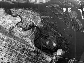
File consists of an oral history given by Donald Prince, which was gathered as part of Dr. Mike Evan's Island Cache Recovery Project. Includes consent forms, transcripts, and the recorded oral history on the original media.
File consists of an oral history given by Lois Richet, which was gathered as part of Dr. Mike Evan's Island Cache Recovery Project. Includes consent forms, transcripts, and the recorded oral history on the original media.
File consists of an oral history given by Junter (Joe) ter Heide, which was gathered as part of Dr. Mike Evan's Island Cache Recovery Project. Includes consent forms, transcripts, and the recorded oral history on the original media.
File consists of an oral history given by Doreen Tosoff, which was gathered as part of Dr. Mike Evan's Island Cache Recovery Project. Includes consent forms, transcripts, and the recorded oral history on the original media.
File consists of copies of 1971 records from the City of Prince George related to Island Cache that were photocopied and organized by researchers involved with the Island Cache Recovery Project. Includes a report on Cottonwood Island by the Advisory Planning Commission, municipal memoranda, a brief on "The Recreation Program on Cottonwood Island", and a brief on the "Reception and Planning Centre". Also includes correspondence from residents of Island Cache, City departments, the Cottonwood Island Residents Association, and others.
File consists of copies of 1972 records from the City of Prince George related to Island Cache that were photocopied and organized by researchers involved with the Island Cache Recovery Project. Includes a "Summary of 1972 Cottonwood Island Records", a table of 1972 snow courses, and a listing of insurance claims. Also includes correspondence from residents of Island Cache, City departments, the Cottonwood Island Residents Association, and others.
File consists of copies of 1972 records from the City of Prince George related to Island Cache that were photocopied and organized by researchers involved with the Island Cache Recovery Project. Includes real estate indentures between property owners and the City of Prince George for Island Cache properties.
File consists of copies of 1972 records from the City of Prince George related to Island Cache that were photocopied and organized by researchers involved with the Island Cache Recovery Project. Includes correspondence from the city to Island Cache residents and correspondence from Island Cache residents to the city. Much of the correspondence from residents are offers to the city to sell their property.
File consists of copies of correspondence to residents of Island Cache from the City of Prince George and correspondence from residents of Island Cache to the city.
File consists of photocopies of material from the collection of Bob Parris. Includes material dated from 1972 organized by Island Cache Recovery Project researchers. Includes copies of newspaper clippings, correspondence regarding the installation of a municipal water system on Cottonwood Island, a document of "Thirteen Little-Known Facts About Cottonwood Island", a notice regarding "Clean-up Procedures Following Flooding", Prince George city bylaw no. 2419, a listing of Island Cache properties "Worth Fixing, Maybe Worth Fixing, and Not Worth Fixing", and notices of hearings from the city.
File consists of photocopies of material from the collection of Bob Parris. Includes material dated from 1973 organized by Island Cache Recovery Project researchers. Includes photocopies of photographs, newspaper clippings, correspondence to and from the City of Prince George, records of property assessment, and personal correspondence to Bob Parris.
File consists of photocopied newspaper articles about Island Cache (Cottonwood Island) and the relocation of its residents.
File consists of photocopied maps of Island Cache (Cottonwood Island) and Prince George.
File consists of an oral history given by Garry Doucette, Bill Henry, and Lucille Henry, which was gathered as part of Dr. Mike Evan's Island Cache Recovery Project. Includes consent forms, transcripts, and the recorded oral history on the original media.
File consists of an oral history given by Violet Findlay, which was gathered as part of Dr. Mike Evan's Island Cache Recovery Project. Includes consent forms, transcripts, and the recorded oral history on the original media.
File consists of an oral history given by Ron Hilde, which was gathered as part of Dr. Mike Evan's Island Cache Recovery Project. Includes consent forms, transcripts, and the recorded oral history on the original media.
File consists of an oral history given by Robert Lewis, which was gathered as part of Dr. Mike Evan's Island Cache Recovery Project. Includes consent forms, transcripts, and the recorded oral history on the original media.
File consists of an oral history given by Robert Parris, which was gathered as part of Dr. Mike Evan's Island Cache Recovery Project. Includes consent forms, transcripts, and the recorded oral history on the original media.
File consists of an oral history given by Joan Paulson and Sharlene Leepart, which was gathered as part of Dr. Mike Evan's Island Cache Recovery Project. Includes consent forms, transcripts, and the recorded oral history on the original media.
File consists of an oral history given by Sharon Simmonds and Ken Switzer, which was gathered as part of Dr. Mike Evan's Island Cache Recovery Project. Includes consent forms, transcripts, and the recorded oral history on the original media.
File consists of an oral history given by Annius Van Driesum, which was gathered as part of Dr. Mike Evan's Island Cache Recovery Project. Includes consent forms, transcripts, and the recorded oral history on the original media.
File consists of photocopies of 1960s records from the City of Prince George related to Island Cache that were organized by researchers involved with the Island Cache Recovery Project. Includes an Urban Renewal Report and municipal memoranda.
File consists of copies of 1972 records from the City of Prince George related to Island Cache that were photocopied and organized by researchers involved with the Island Cache Recovery Project. Includes responses to a survey asking home owners of Island Cache about their interest in the installation of a water main to their property. Also includes city correspondence and memoranda regarding the possible installation of a water system in Island Cache.
File consists of copies of 1972 records from the City of Prince George related to Island Cache that were photocopied and organized by researchers involved with the Island Cache Recovery Project. Includes building inspections and assessments for Island Cache properties. Aldo includes fire inspections and home inventories for insurance purposes.
File consists of copies of 1972 records from the City of Prince George related to Island Cache that were photocopied and organized by researchers involved with the Island Cache Recovery Project. Includes tax assessments for Island Cache properties.
File consists of photocopies of material from the collection of Bob Parris. Includes material dated from 1971 organized by Island Cache Recovery Project researchers. Includes copies of newspaper clippings; a "Report on Flood Protective Measures for Cottonwood Improvement District" from 1969; and newsletters, correspondence, and a petition from the Island Residents' Association.
Series consists of administrative records for the Island Cache Recovery Project. Includes grant funding paperwork, correspondence, and researcher privacy forms.
This map is Schedule C of the 2001 Official Community Plan, Bylaw No. 7281 for the City of Prince George. This Schedule C map shows the long range land use for the City of Prince George.
This map is part of Schedule B of the 1993 Official Community Plan, Bylaw No. 5909 for the City of Prince George. This particular map reflects the 1998 amendment to the Official Community Plan.
This street map of the VLA area in Prince George includes property outlines and street numbers.
This map is the October 2006 amendment (Bylaw 7807) of the Schedule C of the 2001 Official Community Plan, Bylaw No. 7281 for the City of Prince George. This Schedule C map shows the long range land use for the City of Prince George.
This map is the May 2006 amendment (Bylaw 7807) of the Schedule C of the 2001 Official Community Plan, Bylaw No. 7281 for the City of Prince George. This Schedule C map shows the long range land use for the City of Prince George.
Fonds consists of maps, plans, and drawings collected by faculty in the UNBC School of Planning and Sustainability. The majority of these maps reflect the planning history of the City of Prince George and include large format, hand-drawn plans created by the City Planning Department from the 1970s and 1980s. Maps from City of Prince George Official Community Plans are also included.
This map is the May 2008 amendment (Bylaw 8061) of the Schedule C of the 2001 Official Community Plan, Bylaw No. 7281 for the City of Prince George. This Schedule C map shows the long range land use for the City of Prince George.
Subseries contains material collected and created by Kent Sedgwick for research regarding various areas surrounding Prince George. Includes materials on the Crooked River area; Summit Lake; Ferguson Lake; Chief Lake; Salmon Valley; Mud River; Beaverly; Buckwater; Chilako River; Indian Reserve no. 4; Blackburn; Pineview; Stone Creek; Red Rock; Woodpecker; and Hixon. The files primarily consist of research notes and photographs depicting the communities.
Subseries includes research material created and collected by Kent Sedgwick relating to land survey, development, and settlement in Prince George and British Columbia. Land surveys were conducted in British Columbia by surveyors George Dawson, the North Coast Land Company, Alfred R.C. Selwyn, and the Geological Survey of Canada during the late 19th and early 20th centuries. James C. Anderson and engineer J. Gill conducted topographical surveys for the Grand Trunk Pacific Railway on Fort George and the Indian Reserve. Surveyors and land plot companies developed the land for sale to promote settlement in the area. Also includes materials regarding the continued development of the City of Prince George throughout the 20th century. The files primarily consist of newspaper clippings, research notes, and photocopied documents.
Kent Sedgwick’s research subject files contain original research notes, interviews and oral histories, news clippings, and collected primary and secondary sources. The series also includes both original and reproduction photographs, audio recordings, and maps. The subject files primarily relate to the history, urban planning, and historical geography of the Central Interior of British Columbia, especially Prince George area and the East Line communities over the course of the 20th century. They also include extensive notes on geographic features, landscapes, interpretative trails, architectural history, industrial history, history of Western exploration and land survey, and the First Nations history of the region.
Series consists of maps, plans, and drawings collected by faculty in the UNBC School of Planning and Sustainability. The majority of these maps reflect the planning history of the City of Prince George and include large format, hand-drawn plans created by the City Planning Department from the 1970s and 1980s. Maps from City of Prince George Official Community Plans are also included.