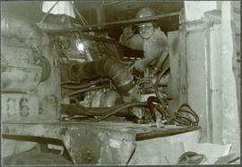
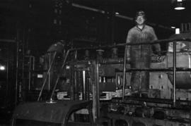
Photograph depicts two unidentified men standing on Ruston Hornsby diesel engine which turned the generators in the power house on the Cassiar plant.
Photograph depicts Darren DeCecco wearing coveralls and hard hat while sitting on a Pacific truck. (Pacifics were used to supply water to mine, remove snow, and supplement ore haul by tramline).
Photograph depicts unidentified man standing in change house located at the new Mine Dry building. This change house utilized baskets which could be lowered under hinged covers, while the previous change house used baskets which could be raised by chains.
Photograph depicts unidentified man operating forklift on right. Pallets of asbestos fibre sit on trailer in background. Two men with clipboard stand in left foreground (David Pewsey on left, Chris Tates on right, see also item 2000.1.1.3.19.212).
Photograph depicts group of seven men in the Engineering/Survey building (former location of old mine dry). Photo believed to have been taken during the weekly meeting in which strategies were discussed for open pit operations (blasting, haulroad, ore and waste zones). Left to right: Danny Demitri, Roger Borsato, Tim Carew, Don Loverin (behind), Tim Williams (seated), Paul Clarke, Paul McRae.
Photograph depicts group of six men in upper meeting room of Engineering/Survey building (former location of old mine dry). Left to right: Tim Carew, Stefan Dyk, Mike Pennock, Paul Clarke, John Oughtred, [unknown].
Photograph depicts kitchen area, serving counter in foreground. Supplies and equipment visible throughout.
Photograph depicts unidentified man seated at one of many dining tables lining large room. Windows visible in background.
Photograph depicts large building behind power lines, car in right foreground.
Photograph depicts woman in right foreground with shopping cart, selecting an item from shelf. Unidentified men, women and child can be seen in background. Store appears to be stocked with groceries and general supplies. Handwritten annotation on recto of photograph: "RIGHT MARG MCKENZIE".
Photograph depicts large trailer truck parked at what is believed to be the loading station on the Cassiar plant (possibly in mill building).
Photograph depicts William (Bill) Storie at location known as Limestone Mountain, southwest of Cassiar, B.C. Photo features profile of Bill, hands in pocket, Cassiar valley and mountains in background. Storie was a renowned prospector in the Cassiar area, and the new school at Cassiar was named for him in 1992.
Photograph depicts unidentified individual and cars on street in foreground, snow banks, trees, and power poles on either side. Buildings can be seen on far right, mountains visible in background. Handwritten annotation on recto of photograph: "townsite Looking East".
Photograph of Prime Minster Pierre Trudeau standing with a group of men looking over the Cassiar valley. Trudeau stands in the middle wearing a yellow shirt.
Photograph depicts Trudeau wearing a white hardhat with his name on the front.
Photograph depicts Trudeau standing outside with a group of men.
Photograph depicts Trudeau standing by trees and brush with a group of men on his Cassiar tour.
Photograph depicts a party of ambassadors standing outdoors and looking at asbestos at Clinton Creek.
Photograph depicts a group of men and women touring inside the mill.
Typed annotation on caption below photograph: "General Superintendent A.C. Beguin receiving 1965 Safety Award for Open Pits and Quarries in British Columbia from Mr. R.B. Bonar, Dept. of Mines and Petroleum Resources." Photograph depicts A.C. Beguin shaking hands with Mr. Bonar as he accepts a large plaque. Counter bar and curtains in background.
Photograph depicts group of 15 men posed in formal room. George Washington Smith (President of Bell Mines) sits in centre on left, shaking hands with Alfred Penhale. Bottom, left to right: Mr. Janitsch, Andrew Johnson, G.W. Smith, Alfred Penhale, unknown, Bill Johnson. Top, left to right: unknown, unknown, C.B. Brown, Pierre Marcotte, F.P. Smith, unknown, unknown, Bill Oughtred, Jack Christian.
Photograph depicts group of eleven men standing in line in the Cassiar valley. Left to right: Jack Christian, Charles Rainforth Elliot, John Drybrough, John E. Kennedy, Fred Martin Connell, W. Harold Connell, Ken A. Creery, George Washington Smith, Tam Zimmermann, [Fred Murray]?, Nick Gritzuk. Power lines and mountains in background. Most men featured in photo are believed to be members of Cassiar's Board of Directors. Photograph was originally framed with note "Summer 1961" written on cardboard backing.
Photograph depicts group of eight men standing on lawn in front of building known as "House 130" or "Director's Lodge". Left to right: Nick Gritzuk, Charles Rainforth Elliot, Jack Christian, W. Harold Connell, Plato Malezemoff (from Newmont Mining), Tam Zimmermann, Ken A. Creery, Fred Martin Connell. Elliot appears to be comparing height with Gritzuk. Trees and mountains in background. Most men featured in photo are believed to be members of Cassiar's Board of Directors.
Photograph depicts three men fishing from shore. Water and trees in background. Left to right: Jack Christian, Plato Malezemoff, Tam Zimmermann.
Photograph depicts man in formal attire holding a cigar in front of ornamented fireplace. Believed to be a member of Cassiar's Board of Directors with the first name David, representing Turner & Newall (manufacturing business based in Manchester, U.K., later known as Turner Brothers Asbestos Company).
Photograph depicts three young women wearing "PRINCESS SILVER STAR" banners, standing to left of "CASSIAR ASBESTOS CORPORATION LTD" display table. Table features photos, rock samples possibly containing asbestos, and objects presumably made from asbestos fibre. Large snowflake symbol visible on wall in background. Photo speculated to have been taken at an event in Vernon, B.C. Handwritten annotation on verso of photograph: "1963".
Photograph depicts a round bucket attached to the main hook line of a crane and suspended over building framework in crusher construction site (crane not visible in image). Men stand around the bucket on high level of crusher building. A dirt road and long building believed to be housing conveyor "B" can be seen in background.
Men can be seen working on site. Crusher building in midground, chutes can be seen crossing the different levels of foundation. Lumber is leaning against excavated dirt wall in foreground, as well as a ladder which reaches up to the base level. Large tank can be seen in top level above building construction. Mountaintop and sky in background.
Handwritten caption below this photo reads: "Completed Foundations for Crusher, with forms being stripped." Men can be seen working on site. Switchback road, power lines and tramline towers are believed to be in valley in background.
Photograph depicts two construction workers in far right sitting on edge above of excavation area, and two construction workers behind them standing at a higher level with construction of lumber walls behind them. The boom and stick of the "Northwest" excavator are semi-visible on left.
Switchback road, power lines and tramline towers are believed to be visible in the background valley. Construction of a long structure near the edge of the excavation area can be seen in midground; this is speculated to be the section of the crusher building which housed conveyor "B".
Handwritten caption beside this photo reads: "View of Pinion & three sections of Crusher". Red rectangular equipment stands enclosed in wood frame, which is also enclosed in the much larger steel frame of the crusher building. Traveler crane on right.
Handwritten caption above this photo reads: "Moving the sides of Bin into place. Weight nine tons" (see also item 2000.1.1.2.365). The bin side is not in view, but cable lines of crane can be seen lowering bin into building. Steel framework and sheeting in background, snow in foreground.
Photograph depicts the large 9 ton side of a bin for the crusher building. It is suspended by a crane which stands behind it, mostly out of picture. Pile of steel beams for framework in foreground, mountainside in background. See also item 2000.1.1.2.365.
Handwritten caption beside this photo reads: "Conveyor 'B'." Conveyor sits on tall steel framework and encased in steel sheeting, elevated over gravel area and small bulldozer. Unidentified buildings in midground, snowy valley in background.
Handwritten annotation on recto of photograph: "POURING RIBS JUNE 29/64." Photograph depicts construction workers on large wooden framework structure extending from base of crusher building. Ladders stand parallel to structure against mountainside. The boom of a crane is visible in foreground. Miscellaneous construction equipment and materials throughout.
Handwritten annotation on recto of photograph: "WEST WALL FOOTING AUG 8/64." Photograph depicts a construction worker standing on rebar in forms built for cement footings. A front end loader and backhoe tractor can be seen on wood platform above footings. Mountainside in background.
Handwritten annotation on recto of photograph: "FURNACE PAD AUG 25/64." Photograph depicts construction worker standing on elevated wood platform. Three other men can be seen working in construction area. This location is believed to be under the conveyor to crusher building, retaining wall in midground.
Photograph depicts large square model of the new mill building that was built at the Cassiar plant site in 1970. Model is displayed on green material set on a platform in snowy area. Machinery modeled inside the structure is colour-coded. Mountain in background.
Photograph depicts the mine road in valley, view from mountain above. Plant, tailings pile, and town visible in distance. South mountains in background. Handwritten annotation on recto of photograph: "1961-1962".
Photograph depicts view of mine road in valley, from mountain above. Plant, tailings pile, and town visible in distance. South mountains in background. Handwritten annotation on verso of photograph: "1961", on recto: Townsite and Plantsite from mine."
Photograph depicts the North peak of McDame mountain in the earlier stages of strip mining, South peak unmined in background. Quonset and other shops visible in left foreground, unknown building built into mountainside in right foreground.
Photograph depicts the Cassiar mine. North peak featured in left background, South peak in right background, and West peak in right foreground. Area to left of the mining pit and West peak was called the "cirque waste dump." Location of new mine garage can be seen just above the "#7 switchback" road in bottom right foreground.
Photograph depicts the Cassiar mine. North peak featured in left background, South peak in right background, and West peak in right foreground. Area to left of the mining pit and West peak was called the "cirque waste dump." Mountain range visible in distance.
Crushing plant and strip mining area visible in Cassiar mountain range.
Photograph depicts the Cassiar mine. North and South peak featured in background, and West peak in left foreground. Pit is being developed between South peak and West peak. Old mine garage is visible in lower centre of image, and crushing plant in right foreground. Mountain range in distance.
Photograph depicts the Cassiar valley: town in foreground, plant and tailings pile behind. Mine road can be seen from plant to mine valley on left. Mountain range in background.
Photograph depicts the Cassiar valley: town in foreground, plant and tailings pile in background.
Photograph depicts the town of Cassiar behind plant buildings in left foreground. Mountain base in background. Photograph was taken from the air, portion of plane visible in top left of image.
Photograph depicts the pit mine, and road in valley below. Town of Cassiar can be seen in distance at foot of south mountain range.