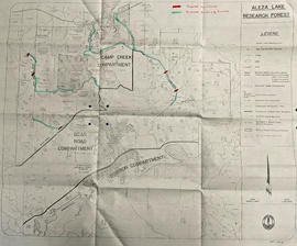
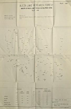
Showing 236 results

Archival description
2002.1.6 · Series · 1887-1992
Part of Prince George Railway & Forestry Museum Collection

This series consists of material created by various societies, companies, railways, unions and government branches for the use and instruction of railway companies and employees. Includes publications, time tables, training materials, union materials, forms, maps and plans related to rail operations in North and South America, but predominately related to Canadian railway operations. Also comprises material created by several American and Canadian railways and transportation companies.

2002.1.8 · Series · 1912-1992
Part of Prince George Railway & Forestry Museum Collection

The Miscellaneous Forest History Material series consists of material created or used by various logging and pulp mill companies. Includes forms, union materials, maps, plans and other records related to the forestry sector in British Columbia. The series also comprises publications related to equipment and employee training, and correspondence and memorandum developed by B.C. Chemicals, a division of Canfor.

2002.1.1 · Series · 1914-1993
Part of Prince George Railway & Forestry Museum Collection

The Canadian National Railway series consists of administrative records, safety records, correspondence between departments, labour records, records pertaining to train movements, maintenance records, and ephemera. Includes publications concerning the topics of unionized labour, railway operation, maintenance of way, handling of hazardous materials, safety, public interest, and the two Royal Tours of 1939 and 1959. Also consists of maps and technical drawings depicting Canadian National Rail lines and equipment.

Canadian National Railway
2023.5.1.29 · Item · 1 Nov. 1993
Part of UNBC School of Planning and Sustainability fonds

This map is part of Schedule B of the 1993 Official Community Plan, Bylaw No. 5909 for the City of Prince George. This particular map depicts the northeast area of the City of Prince George, including the industrial areas on Prince George Pulpmill Road and Northwood Pulpmill Road along the Fraser River.

2007.1.80.1.12 · Item · 1993
Part of Aleza Lake Research Forest fonds

Map reflects forest type boundary line, bogs and swampy non-forested areas, creeks, lakes, rivers, tree species labels of spruce, balsam, and birch, stand descriptions, historical timber sale boundaries, stand history symbol, gravelled secondary roads, unimproved old roads, management compartment boundary, research forest boundary, ecological reserve boundary, and old growth emphasis areas.

2007.1.80.1.13 · Item · Mar. 1994
Part of Aleza Lake Research Forest fonds

Large scale map shows Aleza Lake Research Forest permanent sample plot 103. Includes information about live and dead trees and their species (spruce, balsam, birch, douglas fir). Also includes remeasurement history. Plot 103 was established in 1926 and is an unlogged, old growth, uneven aged, spruce-balsam stand.

2007.1.80.1.14 · Item · Mar. 1994
Part of Aleza Lake Research Forest fonds

Large scale map shows Aleza Lake Research Forest permanent sample plot 112. Includes information about live and dead trees and their species (spruce, balsam, birch, douglas fir). Also includes remeasurement history. Plot 112 was established in 1926 and is an unlogged, old growth, uneven aged, spruce-balsam stand.