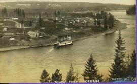
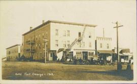
Mostrar 184 resultados

Archival description
161 resultados com objetos digitais Mostrar resultados com objetos digitais
Trains and People
2012.13.1.19.07 · Item · 1979
Parte de J. Kent Sedgwick fonds

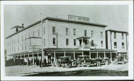
Image depicts a train and a group of unknown individuals at the GTP roundhouse in Prince George, B.C.

GTP Roundhouse
2012.13.1.19.06 · Item · 1979
Parte de J. Kent Sedgwick fonds

Image depicts the Grand Trunk Pacific railway roundhouse in Prince George, B.C.

GTP Roundhouse
2012.13.1.19.05 · Item · 1979
Parte de J. Kent Sedgwick fonds

Image depicts the Grand Trunk Pacific railway roundhouse in Prince George, B.C.

Train Fuelling Station
2012.13.1.19.04 · Item · 1979
Parte de J. Kent Sedgwick fonds

Image depicts what is possibly a train fueling station at the GTP Roundhouse in Prince George, B.C.

Train Fuelling Station
2012.13.1.19.03 · Item · 1979
Parte de J. Kent Sedgwick fonds

Image depicts what is possibly a train fuelling station at the GTP Roundhouse in Prince George, B.C.

Train Fuelling Station
2012.13.1.19.02 · Item · 1979
Parte de J. Kent Sedgwick fonds

Image depicts what is possibly a train fuelling station at the GTP Roundhouse in Prince George, B.C.

GTP Roundhouse
2012.13.1.019 · Subsérie · [between 1979 and 1983]
Parte de J. Kent Sedgwick fonds

File contains slides depicting images of the Grand Trunk Pacific railway roundhouse in Prince George, B.C.

Highway
2012.13.1.7.246 · Item · Mar. 2003
Parte de J. Kent Sedgwick fonds

Image depicts a highway, possibly Highway 97, in Prince George, B.C.

Highway 97
2012.13.1.7.224 · Item · May 2001
Parte de J. Kent Sedgwick fonds

Image depicts a view along Highway 97 in Prince George, B.C.

CN Building
2012.13.1.7.218 · Item · May 2001
Parte de J. Kent Sedgwick fonds

Image depicts the CN Building in Prince George, B.C.

Paddlewheel Park
2012.13.1.7.202 · Item · Nov. 2000
Parte de J. Kent Sedgwick fonds

Image depicts the Fraser River at Paddlewheel park, with a train on the other side of the river, in Prince George B.C.

Paddlewheel Park
2012.13.1.7.201 · Item · Nov. 2000
Parte de J. Kent Sedgwick fonds

Image depicts the Fraser River at Paddlewheel park, with a train on the other side of the river, in Prince George B.C.

British Columbia Rail
2012.13.1.5.30 · Item · Mar. 2003
Parte de J. Kent Sedgwick fonds

Image depicts an aerial view of the BC Rail, in Prince George, B.C. It is now known as CN Rail.

Highway 97
2012.13.1.3.164 · Item · May 2001
Parte de J. Kent Sedgwick fonds

Image depicts a section of Highway 97 looking south. Map coordinates 53°55'10.3"N 122°46'54.9"W

Fifth Avenue Intersection
2012.13.1.3.163 · Item · May 2001
Parte de J. Kent Sedgwick fonds

Image depicts the intersection of 5th Ave and Highway 97 looking northeast. Map coordinates 53°55'14.0"N 122°46'54.8"W

CN Train Yard
2012.13.1.3.121 · Item · 12 Oct. 1989
Parte de J. Kent Sedgwick fonds

Image depicts a number of trains in the CNR train yard taken from River Road in Prince George, B.C. Map coordinates 53°54'51.5"N 122°43'29.6"W

Prince George to Tete Jaune
2011.3.4.14 · Item · [ca. 1901-1915]
Parte de North Coast & Central BC Postcard Collection

Stern wheeler in river. Handwritten annotation in pencil on verso reads: “Prince George to Tete Jaune” Hand written message in ink on verso is addressed to “Mademoiselle Elisabeth Joliet, Terrguy – Les Dijore Cote a Or France”

George Street in Prince George, BC, 1921
2011.3.2.17 · Item · 1921
Parte de North Coast & Central BC Postcard Collection

Photograph of George Street in Prince George B.C. Cars, people, and signage are visible. Printed annotation on recto reads: “George St. Prince George B.C. 1921 R7 by Moore” There is an “X” in ink over the fire hall. Handwritten annotation in ink on verso reads: “This view is also looking north and where I have put the X is the one and only fire hall and you can see the fire engine in the street. This is the main street.”

Street in Prince George, BC
2011.3.2.14 · Item · [ca. 1920]
Parte de North Coast & Central BC Postcard Collection

Street scene in Prince George B.C. Several Union Jack flags are visible and there is a celebration banner at the end of the street. Long shadows in photo indicate summer (perhaps Dominion Day?). River in foreground, railroad and city in mid ground and hill in background. Printed annotation on recto reads: “Prince George. B.C.”

View of Prince George, BC from Above
2011.3.2.13 · Item · 1921
Parte de North Coast & Central BC Postcard Collection

Boardwalk in foreground, buildings and roads in mid ground, cut banks in background. Printed annotation on recto reads: “Prince George. B.C. 1921 by Moore”. Handwritten annotation in ink on verso reads: “The Netchaco river is between the mountain and the city and the C.N.R. runs along the river bank nearest the city. This picture is taken looking north.”

View of Fort George, B.C. from Above
2011.3.2.05 · Item · 1913
Parte de North Coast & Central BC Postcard Collection

Lofty view of South Fort George, river and treed hills in the background. Printed annotation on verso reads: “South Fort George - 1913.” Handwritten message on recto is addressed to “Ethel M. Heurris Norton Maps Bristol County" reads: "11-1-13 an excellent view of south Fort George taken recently. Power Station at cross near water. This does not give all the south residence view. Population approx 1500”.

Cars along Third Ave., Prince George, BC
2011.12.03 · Item · ca. 1950
Parte de Giscome, BC Historical Photograph collection

Photo depicts a street perspective cars lining Third Avenue, in Prince George, BC, ca. 1950. Annotation recto reads: "3rd Ave Prince George BC Photo J. Wrathall." Handwritten annotation in pen on verso of postcard reads: “This is the equivalent of our Granville Street. Both theatres are located here as well as Hudson Bay Co., banks, library & stores.”

George St., Prince George, BC
2011.12.02 · Item · ca. 1950
Parte de Giscome, BC Historical Photograph collection

Photo depicts a street perspective of George St., in Prince George, BC, ca. 1950. Annotation recto reads: "George St. Prince George BC Photo by J Wrathall." Handwritten annotation in pen on verso of postcard reads: “This is the Hastings Street of Prince George. This & 3rd Streets are the main thoroughfares.”

Third Ave., Prince George, BC
2011.12.01 · Item · ca. 1950
Parte de Giscome, BC Historical Photograph collection

Photo depicts a street perspective of Third Ave., in Prince George, BC, ca. 1950. Handwritten annotation in pen on verso of postcard reads: “You will undoubtedly notice that there are no tall buildings. I don’t think that there is one building in Prince George that is even five stories tall.”

British Columbia: Satellite Image Map
2009.6.13.45.19 · Item · 1975
Parte de The Honourable Iona Campagnolo fonds

Map depicts annotations marking the major freight-ways: Garnet Ent. Truck Haul from Vancouver to Terrace, Canada Freightways Lyndon Trucking from Vancouver-Edmonton-Alaska Highway, Lindsays Transfer from Terrace to Dease Lake and Telegraph Creek, and the Northland Navigation roll-on and roll-off service. The cities and towns of Vancouver, Prince George, Dawson Creek, Terrace, Kitimat and Whitehorse are noted.

Taped conversation with Julian Fry transcript
2009.5.4.60 · Item · May 1981
Parte de Taylor-Baxter Family Photograph Collection

Julian Fry reminisces on his early life and acquaintances in Prince George during his work along the Blackwater Road in the early 1920's. Some notable references include: Blackwater Road, C.F.S. Baldy Hughes, Bill Comstock, Tom Cornell, Duncan MacKenzie, Ernest Levesque, [?] Hathaway, [?] Nelson, Ed and Julia Erickson, Blackwater Telegraph Station, Everett Vandenburg, and [?] Mackenzie.