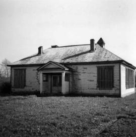
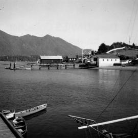
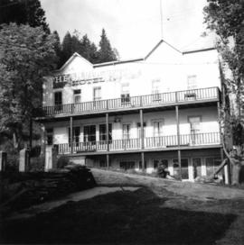
Photograph depicts the Silver Ledge Hotel, Ainsworth Hot Springs, on the west side of Kootenay Lake, north of Nelson.
Photograph depicts a barn at Darfield, near Barriere, about 35 miles north of Kamloops. The English timbered cottage developed from this architectural form.
Photograph depicts East Pender St., looking west towards the Vancouver Sun newspaper office near Abbot St. in Vancouver, B.C.
Photograph depicts the Upper Clearwater Hall on a dirt road between Clearwater (70 miles north of Kamloops) and the entrance to Wells Gray Provincial Park. The cracks between the logs recently re-cemented.
Photograph depicts a barn at Port Guichon, 1 mile west of Ladner, Delta.
Photograph depicts the Delta Municipal Hall on Main St. in Ladner, B.C.
Photograph depicts a disused schoolhouse with the dates "1925" and "1902" on it. It is on River Rd. on the south bank of the Fraser River in Delta, opposite the west end of Annacis Island.
Photograph depicts Alberni St. in the west end of Vancouver. It is directly opposite the Vehicle Testing Station, in the 1700 block. The view in the photo is looking east.
Photograph depicts a courthouse in Vancouver, B.C. surrounded by a fence with paintings.
Photograph depicts a painting on a fence outside a courthouse on Howe St. in Vancouver, B.C. The painting shows the natural grandeur of B.C. partially blocked out by a super motel with a bewildered moose forced to become an ornamental fountain. The whole forecourt is being bulldozed to make way for the Centennial fountain.
Photograph depicts a wharf at Sechelt village on the Sechelt Peninsula. The view is looking southeast towards Vancouver.
Photograph depicts a car parked on the road between Kaslo and New Denver, on the site of a former railway right-of-way.
Photograph depicts a bear at the garbage dump of the Gold River logging camp. Five other bears have retreated to the fire weed and blackened tree stumps.
Photograph depicts a view looking northwest at Osoyoos Lake, B.C.
Photograph depicts Tofino on Vancouver Island. View taken from wharf with a lifeboat on slip.
Photograph depicts a house fire possibly on 1000 Beach Block and Thurlow St. , caused by a wrecking gang.
Photograph depicts house at #1053 Beach Ave. in Vancouver, B.C. Dan Davies was a resident at one time.
Photograph depicts Beach Ave. in Vancouver, with the photo taken near the swimming pool and looking west. Photo was taken after a storm.
Photograph depicts home at #1053 Beach Ave., which is now fully demolished.
Photograph depicts a field being cleared near Miracle Beach, 20 minutes south of Campbell River, on Vancouver Island.
Photograph depicts land clearance between Monashee Pass and Lumby, B.C.
Photograph depicts telephone fittings on Vancouver Island.
Photograph depicts a small coal tram at Tsable coal pit near Fanny Bay on Vancouver Island.
Photograph depicts a general view of Coal Harbour in Vancouver, looking southeast and south with Marine Building (downtown) on extreme left and Stanley Park (unseen) at extreme right.
Photograph depicts a reaction ferry at Blackpool, near Clearwater on the north Thompson River, about 65 miles north of Kamloops. At least 3 such ferries exist north of Kamloops. In freshet the trip takes 1 minute, in low water 15-20 minutes. The other two ferries are equipped with outboard motors in 1964. The ferry broke loose in flood water in approximately 1960.
Photograph depicts Simon Fraser University in Burnaby, B.C. The view is looking southwest from the mall towards the gym and sports arena.
Photograph depicts Simon Fraser University in Burnaby, B.C. The view is looking east towards the nearly completed water tower from the west inner face of the Academic Quadrangle.
Photograph depicts the view looking north from Diamond Head Lodge in Garibaldi Park, about 20 miles northeast of Squamish. Believed to be "Bookworm range" at 7910 ft.
Photograph depicts the general view of the waterfront buildings between Burrard and Thurlow St., in Vancouver Harbour looking northwest from Burrard St. The Immigration Building is on the left and the "Princess of Vancouver" (C.P.R.) is in the middle distance.
Photograph depicts the Britannia Copper Mine in Howe Sound. The view is looking southeast.
Photograph depicts a fence at Nicola village, 7 miles northeast of Merritt.
Photograph depicts a view of downtown Vancouver taken from the east end of False Creek at the foot of Terminal Ave. The view is looking northwest. In the middle distance on the left is the pier of a railway bridge taking the Great Northern Railway line into the city. It was demolished in about 1915-1920 when a new Great Northern station was constructed.
Photograph depicts Lund Harbour, looking north, 12 miles north of Powell River. It is the most northerly point on the mainland accessible by car, on this part of the coast. Lund is 92 car miles north of the ferry terminal at Langdale.
Photograph depicts the north bank of False Creek in Vancouver, B.C. The photograph was taken from the Cambie Bridge, with a view looking west.
Photograph depicts the Albion Ferry on the Fraser River, as it approaches a ferry slip at Fort Langley.
Photograph depicts a log boom probably in the Lower Mainland or on Vancouver Island.
Photograph depicts dumping logs at Gold River on the west coast of Vancouver Island.
Photograph depicts a baby seal at C.N. log drop at Cowichan Lake on Vancouver Island.
Photograph depicts a lumber mill probably in the Lower Mainland.
Photograph depicts pole climbing in logger sports probably at Squamish, B.C.
Photograph depicts logger sports at Squamish, B.C.
Photograph depicts a logging museum in Ladysmith on Vancouver Island.
Photograph depicts a steam donkey beside a mill pond of a shingle mill at Sappho or Tyee, on the Olympic Peninsula. It is steam fed from the main plant boiler.
Photograph depicts a beehive burner at Brownsville Sawmills Ltd. On Olson St. in south Westminster, Surrey. It is on the banks of the Fraser River just below the Patullo Bridge.
Photograph depicts a small sawmill on the Old Yale Rd., near the intersection of Robson Rd. in South Westminster, Surrey.
Photograph depicts a log on an old trailer bed.
Photograph depicts a general view of the Horne Bros. shingle mill on #305 West Esplanade Rd. in North Vancouver.
Photograph depicts a steam crane in the yard of the Lions Gate Lumber Co. on the foot of Lloyd St. in the North Vancouver. It has been freshly painted with a yellow exterior, white interior, and black boiler.
Photograph depicts a lumber yard on the north side of Porpoise Bay in Sechelt on the Sechelt Peninsula. The tank in the photograph is about 8 to 10 feet in diameter.