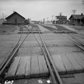
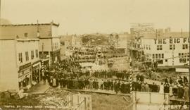
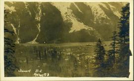
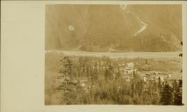
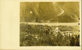
Image depicts rail road tracks and several buildings in Pemberton, B.C.
Image depicts a view of Peden Hill in Prince George, B.C.
Photograph depicts peat barns on the New Westminster Highway on Lulu Island, near the #8 Rd., half a mile west of rail crossing.
Image depicts the Pearson Homestead.
Photograph depicts buildings and signage on either side of dirt road. Unidentified man stands on far left, Atlin Lake and mountains can be seen in background.
Hand inscribed annotation on recto of photograph reads: “Pearl St., Atlin, B.C. Aug. 1899. A.C. Hirschfeld, No.74”.
Photograph depicts tent buildings on either side of dirt road. Unidentified men are visible on left, Atlin Lake and mountains can be seen in background.
Hand inscribed annotation on recto of photograph reads: “Pearl Av. looking towards Atlin Lake, Atlin, B.C., A.C. Hirschfeld, No. 174”
Image depicts a street of shops at an uncertain location somewhere in the Peace River Regional District. A pink and blue building, possibly a theatre, is labelled "Lux."
Image depicts the W.A.C. Bennett Dam on the Peace River in Hudson's Hope, B.C.
Image depicts a dam and a reservoir of water, possibly on the Peace River.
Image depicts a dam, possibly on the Peace River.
Image depicts a dam on what is possibly the Peace River.
File contains slides depicting places along the Peace River.
Image depicts the Peace Canyon Dam and generating station under construction on the Peace River.
Side perspective photograph of a Portland Canal Short Line engine being either loaded or unloaded by several men at the station in Stewart, BC. Printed annotation on recto reads: "Aug 9 1911 Stewart BC."
Image depicts the remains of an old bridge, somewhere near Pavilion Mountain.
Image depicts the First Nations village of Pavilion, B.C.
Image depicts an old theatre owned by Paul Aivazoff in Prince Rupert, B.C. It opened in 1935 and was closed in 1981; it has since been renovated for retail use.
The photograph depicts a blurred image of a yellow carpet with colourful designs.
Photograph depicts the Nanaimo passenger depot of the Esquimalt and Nanaimo Railway (at right) and the E & N freight shed (at left).
Image depicts several eighteen wheelers at the Pass Lake Road and Upper Fraser Road intersection with numerous houses and buildings in the background in McGregor, B.C. Map coordinates 54°04'38.1"N 121°50'00.1"W
Photograph depicts a partially demolished Great Northern Railway depot and Canadian National Railway (CN) depot behind it, in Vancouver.
Overhead view of a block of business and harbour buildings in Prince Rupert BC. The "Savoy Hotel" is visible in the foreground. Printed annotation on recto reads: "Part of Business Section & Harbour. Prince Rupert B.C. F. Button Photo Pr. Rupert No. 494."
Image depicts Parkside Intermediate Care Home on Ospika Boulevard in Prince George. Map coordinates 53°55'02.6"N 122°47'41.6"W
Image depicts a group of people throwing a frisbee in a parking lot at an uncertain location, likely in the Peace River Region.
Photograph depicts a parking lot and alleyway behind the Europe Hotel on 3rd Avenue.
This item is a photograph of a yellow parkade in downtown Prince George. Liquidation World can be seen in the background.
This item is a photograph of a yellow parkade in downtown Prince George.
Photograph of several floats parading down Second Avenue in Prince Rupert. A large crowd is gathered. Annotation on recto reads: "Photo by MacRae Bros Prince Rupert BC Prince Rupert B."
Balcony overlooks Terrace Gardens in Victoria, B.C.
Photograph depicts a painting on the fence outside a courthouse on Howe and Granville St. In Vancouver, B.C. Each artist was granted a permit and panel by City Council.
Photograph depicts a painting on a fence outside a courthouse on Howe St. in Vancouver, B.C. The painting shows the natural grandeur of B.C. partially blocked out by a super motel with a bewildered moose forced to become an ornamental fountain. The whole forecourt is being bulldozed to make way for the Centennial fountain.
Photograph of many loaded pack horses in front of the "McMillan Transfer Company." Printed annotation on recto reads: "Pack-Train At Bitter-Creek Hughes 116."
Photograph depicts the Pacific Press Ltd. Vancouver Sun building at Beatty and West Pender St. The view is looking northeast from Beatty St. It was vacated by the Vancouver Sun at Christmas 1965 with the neon "Sun" sign on the tower removed.
Photograph of a large waterfront factory. Annotation on recto reads: "Pacific Mills, Ocean Falls, BC. No. 2935."
Photograph of Stewart BC taken from a distance. Trees in the foreground slightly obscure the village, and a large mountain is visible in the background. Printed annotation on recto reads: "Stewart B.C. Hughes 93."
Postcard overview of several identifiable storefronts built amongst the rocky outcrops of Prince Rupert. Printed annotation on recto reads: "Prince Rupert BC."
Overhead photograph of Prince George, BC ca. 1950 with hills in background. Annotation on recto reads: "Prince George, B.C."
Overhead photograph of Giscome buildings with Eaglet Creek running through the foreground. Handwritten annotation in pen on verso reads: “Notice the flatness of the land. Part of our community.”
Overhead photograph of Giscome with the Eagle Lake Sawmill's beehive burner clearly visible in left foreground. Handwritten annotation in pen on verso reads: “Part of our community. school * ”
Elevated street view of Fulton Street in Prince Rupert, BC. City Hall is in the left foreground. Hills and water are visible in the background. Printed annotation on recto reads: "Prince Rupert. B.C."
Photographic overview of the Eagle Lake Sawmill. Handwritten annotation in pen on verso reads: “The mill.”
Overhead photograph of a forested area, with Stewart, BC visible in the distance.
Overhead view of commercial buildings in downtown Prince George. Printed annotation on recto reads: "Prince George, B.C."
Overhead view of a residential area in Prince Rupert, BC. Printed annotation on recto reads: "Prince Rupert, BC Photo by J.W."
Wide angle photograph of many buildings scattered in a clear cut area. Foreground shows several businesses, including "Kelly Carruther's Supply" and "Prince Rupert Hardware and Supply Co." Some remaining forest is visible in the background. Annotation on recto reads: "Prince Rupert, BC 1659."