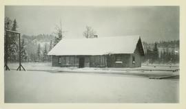
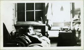
Image depicts a few houses in Island Cache. There are two unknown individuals present.
Image depicts a few houses and a dog on a porch at Island Cache.
Image depicts a number of small houses at Island Cache.
Image depicts a house, most likely on Thompson Drive in Prince George, B.C.
Photograph of Prince George Hotel with several early model cars and a few people. Printed annotation on recto reads: “Hotel Prince George, Prince George, B. C.”
Street view of many vehicles parked in front of the Hotel Northern. Printed annotation on recto reads: "Hotel Northern, South Fort George."
Photograph depicts street corner view of Hotel Fort George with people and utility pole in foreground.
Handwritten annotation on verso “Hotel Fort George Central Fort George 1913".
Photograph depicts Hotel Fort George with people, cars and power pole in foreground. Handwritten annotation on verso reads: “Hotel Fort George - 1913”.
Photograph depicts the Hong Kong Inn and restaurant at 1210 3rd Avenue. Annotation on verso: "Dredaute Bldg c. 1948".
Image depicts the power lines in the Hixon area south of Prince Georg, B.C.
This 75th anniversary history of the Quest Club presented by Margaret Moffat and Joan Grainger at a celebratory luncheon held at Esther's Inn on October 12th, 1999 was gleaned from the History of the Quest Club prepared by Joy McMillan and Joan Grainger in 1984 for the 60th Anniversary of the Quest Club, and from Minutes of the Quest Club meetings up to 1999.
The Quest Club was started by six Prince George women who quested for more information in all fields of knowledge.
Series consists of records created or accumulated by the Aleza Lake Research Forest Society regarding the research forest's history. Includes oral histories and material from long-time personnel that worked at the ALRF, such as Harry Coates, John Revel, and Frank Hellenius. Also contains copies of archival records from other archival institutions that concern the history of ALRF, which were compiled as part of a 2006/2007 history internship project.
File consists of an oral history given by Hilliard Clare, which was gathered as part of Dr. Mike Evan's Island Cache Recovery Project. Includes consent forms, transcripts, and the recorded oral history on the original media.
Image depicts a view along Highway 97 in Prince George, B.C.
Image depicts Highway 97 at 15th Ave. looking north. Map coordinates 53°54'36.0"N 122°46'55.5"W
Image depicts Highway 97 at 15th Ave. looking north. Map coordinates 53°54'42.1"N 122°46'53.1"W
Image depicts a section of Highway 97 looking south. Map coordinates 53°55'10.3"N 122°46'54.9"W
Videotape contains footage of: 15-May-05 - Scenery - highway 16 rail lines, Prince Rupert map, and highway sign
Image depicts a highway, possibly Highway 97, in Prince George, B.C.
Fonds consists of records relating to the personal, business and political life of H.G.T. Perry and as such, has been divided into the following four series: 1) Photographs; 2) Political Activities; 3) Business Ventures; 4) Personal Life; and 5) Miscellaneous Historical Information Files. Also includes material relating to his son, Frank Perry, and his failed political campaign. Includes World War II and Post-War printed materials.
Types of records included in this fonds include Speakers' Decisions (1877-1943) in the BC Legislative Assembly, maps, publications, reports, correspondence, advertisements, telegrams, resolutions, minutes, annual reports, telegrams, resolutions, reports, speeches, press releases, proposals, plans, charts, file notes, memoranda, newspaper clippings, scrapbooks, ephemera, postcards and photographs.
Perry, Harry G.T.The women are seated on old farm plow in forest clearing, both wearing hats. Mrs. Dixon is the wife of Hugh's employer Mr. Dixon, and is not related to the Taylors. Handwritten annotation on recto of photograph: "Mother & Mrs. Dixon - 1921 -"
File contains slides depicting the opening of the Cottonwood Park section of the Heritage River Trails in Prince George, B.C.
Image depicts a section of the Heritage Trail in Cottonwood Park.
File consists of records created and collected by Kent Sedgwick regarding the Heritage River Trails System and surrounding park areas in Prince George such as Cottonwood Island Park. Highlights include:
- Full page newspaper feature in The Citizen written by Kent Sedgwick that includes a detailed history of Cottonwood Island Park and the River Trails as well as a contest for naming the trail system (2 Nov. 1984)
- Graham Farstad, Director of Planning, City of Prince George, "Prince George's Heritage River Trail System" document, May 1986
- records relating to the dedication plaque for the opening of the trails
- "Heritage River Trails: A Guide to the Pathways along the Fraser and Nechako Rivers, Prince George, British Columbia" brochures created by Kent Sedgwick
- map on transparency depicting the Heritage River Trails System
File consists of an oral history given by Heinz Bartkowski, which was gathered as part of Dr. Mike Evan's Island Cache Recovery Project. Includes consent forms, transcripts, and the recorded oral history on the original media.
Image depicts a piece of heavy machinery lifting numerous logs. It is likely located in Prince George, B.C.
Image depicts a piece of heavy machinery lifting numerous logs off the back of a logging truck. It is likely located in Prince George, B.C.
Slide depicts a man operating heavy equipment in a forest, likely at the Aleza Lake Experiment Station.
Photograph depicts nine or more people watching a steamer navigate the rough waters of Fort George Canyon from the river shore.
Photograph depicts the rough waters and rocks at Fort George Canyon.
Videotape contains footage of: 30-May-06 - Hazelton and Quesnel graduation events
Photograph depicts Harvey Chometsky at "Words, Loves" conference.
Image depicts a neighbourhood on the Hart Highway in Prince George, B.C.
Item is a hand drawn and coloured map by the City of Prince George Planning Department depicting Hart Highway neighbourhood area existing land use in 1976.
City of Prince GeorgeFile contains slides depicting places along the Hart Highway.
Image depicts Glenview Drive near the Hart Highway in Prince George, B.C.
Harry Weaver Memories consists of a copy of the typed manuscript of Harry Weaver's autobiography, as well as various other related trapping information.
Fonds consists of one copy of a manuscript of Harry Weaver's autobiography and copies of various accompanying records, as well as one black & white copy print photograph depicting the Weaver family.
Weaver, HarryCollection consists of textual and photographic items related to Prince George hockey and sports history.
Handwritten annotation on recto of photo reads: "Harry Monson Edmonton Prince George." Harry reclines on bed under window, surrounded by personal effects. Photograph was taken after nightfall. Handwritten caption beside this photo reads: "Harry talked my dad into selling him my boat".
File consists of Harry Gairns' speaking notes for his 18 Sept. 2009 banquet talk at the "Exploring Our Roots: Forest History in Our Communities Annual Conference of the Forest History Association of BC" at UNBC in Prince George, September 19, 2009. Gairns' speech was entitled "Prince George Forest History - The 50s and the 60s".
Photograph depicts Harry Coates, Ted Baker, and John Revel at Aleza Lake Research Forest re-opening ceremony on July 9, 1992.
File consists a transcript of an oral history with Harry Coates recorded by Barbara Coupe.
File consists an audio recording of an oral history with Harry Coates recorded by Barbara Coupe.
File consists an oral history with Harry Coates recorded by Barbara Coupe. Includes a transcript and audio recording.
File consists a transcript of an oral history with Harry Coates recorded by David Mills.
File consists an audio recording of an oral history with Harry Coates recorded by David Mills.