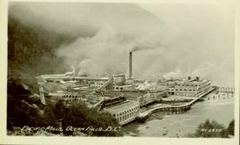
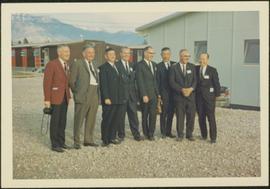
Item is a photograph of officials attending the June opening of the Crestwood Forest Industries pulp mill in Cranbrook, until that time the only pulp mill built without benefit of a Pulp Harvesting Area (PHA) license to assure timber supply. Mr. Williston is on the left.
Subseries contains materials related to operational expenditures for Fyfe Lake Fir. Includes receipts, orders, expense booklets, and accounting information.
Operator loading Asbestos into feeder at Welshpool Asbestos Mill in Australia.
Valley and mountain range visible in background. Handwritten annotation on recto of photograph: "Cassiar June 1970 / Looking South to 6200 Switch-back -".
Photograph depicts exposed asbestos fibre in talus below outcrop. Handwritten annotation on verso of photograph: "Sept 1954."
Photograph depicts a pick hammer hanging from outcrop. Annotations on note glued to recto of photograph: "ASBESTOS"; "Outcrop of fibre bearing serpentine about centre of deposit and vertically over 300 adit on western slope." Areas of image have been labeled "A" and "B". Photo caption under printed copy of image in 1952 Annual Report: "A - indicates asbestos talus. B - indicates asbestos veinlets."
Series consists of large format maps and plans relating to railways in British Columbia and Canada. Also includes oversize documents.
Handwritten caption beside this photo reads: "Damage to Cassiar Grader, result of hazardous access to site". Rocks and rubble in foreground, mountain in background. Grader appears to be sitting on edge of cliff.
Photograph depicts large dump truck on its side in snowy forest clearing, exhaust still running. Lumber piles in foreground. Handwritten caption above this photo reads: "Over Easy".
Photographic overview of the Eagle Lake Sawmill. Handwritten annotation in pen on verso reads: “The mill.”
Overhead photograph of Giscome with the Eagle Lake Sawmill's beehive burner clearly visible in left foreground. Handwritten annotation in pen on verso reads: “Part of our community. school * ”
Photograph depicts an oxen powered log carrier with wheels that are approximately 10 feet in diameter. It is at Pioneer Park and Museum near Totem Lake, 3 miles north of Yahk and 30 miles east of Creston.
File consists of material relating to the Pacific Great Eastern Railway Company. Chartered as a private company in 1912 as the Pacific Great Eastern Railway (PGE), the company was acquired by the BC provincial government in 1918. In 1972 it was renamed as the British Columbia Railway and in 1984 it took on its present name of BC Rail. Materials include newspaper clippings, a report, correspondence, maps, a brief, reproductions of articles, a booklet, and a proposal. Highlights include:
- Hi-Ballers Railroad Club, "The Pacific Great Eastern Railway Company", Vol. 3 No. 1 1960 (reproduction from magazine)
- Province of British Columbia Department of Railways, "Pacific Great Eastern Railway also Proposed Extensions and Potential Resources of Central Interior and Northern British Columbia, 1949" (reproduction)
- Province of British Columbia, "Royal Commission on British Columbia Railway, Interim Report on the Future of the Fort Nelson Extension", 1977 (booklet)
- Ministry of Mines and Petroleum Resources, "Mineral Deposit-Land use Map - Figure 1", 1977 (map)
- Ministry of Mines and Petroleum Resources, "Mineral Deposit-Land use Map - Figure 2", 1977 (map)
- Ministry of Mines and Petroleum Resources, "Mineral Deposit-Land use Map - Figure 4", 1977 (map)
- Ministry of Mines and Petroleum Resources, "A Brief Submitted to the Royal Commission on the British Columbia Railway", 1977 (booklet)
Sign says "Pacific Great Eastern Railway Company - Explosives - Handle Carefully - Keep Fire Away - North Vancouver Station June 25 1969". Also includes condensed rules for handling cars with explosives.
Photograph of a large waterfront factory. Annotation on recto reads: "Pacific Mills, Ocean Falls, BC. No. 2935."
The photographs depict the geographic areas of Stewart, BC, Boundary Pass, Nelson River, Bitter Creek Glacier, Portland Canal, Red Cliff and Bear Creek; as well as the ships “Camosun” and “S.S. Prince George.” Types of subjects identified in this collection include: community life, surveying, mining and transportation (i.e. dog-sledding, horse and buggy, and the Portland Canal Short Line Railway “P.C.S.L. Rlwy”).
File consists of material relating to the Peace River. Materials include a newspaper, magazines, a booklet, pamphlet, and reproductions of correspondence. Highlights include:
- Community West, "Dawson Creek the place to live", Vol 2. No. 7 1980 (magazine)
- Grande Prairie Chamber of Commerce, "Welcome to Grande Prairie, A Visitors Guide", [197-?] (booklet)
- District of Chetwynd, "Chetwynd Resource Centre of B.C.", 1982 (booklet)
- B.C. Hydro, "W.A.C. Bennett Dam Peace River", [197-?] (pamphlet)
Photograph depicts the lumber yard at Peden Hill sawmill, likely after the fire that burnt down the first mill at that location.
Image depicts an aerial view of areas that have been used for logging around Prince George, B.C.
Image depicts an aerial view of the Ahbau area somewhere near Prince George, B.C.
The Photographic Materials series consists of 6100 photographs, 900 slides and negatives documenting a wide variety of subject areas pertaining to both the operations of Cassiar Asbestos Corporation Ltd., and the company township of Cassiar, B.C. Types of subject areas found within this series include, but are not limited to: mine, plant, labour, and townsite operations at the company towns of Cassiar and Clinton Creek (including community activities associated therein and townsite development); construction of plant and mine buildings ; mines and equipment not owned by Cassiar Asbestos Corporation, but which are believed to have been used for operational research purposes ; aerial photographs ; company exploration of further mineral deposits outside of Cassiar ; official tours ; community images, promotional material ; executive portraits. The Photographic Materials series has been further subdivided into the following 4 subseries: Exploration & Development, Construction, General (Mining) Operations & (Townsite) Community Operations, and Corporate Affairs.
File contains photographs of The Pas Lumber Company Ltd. Includes other northern BC forestry industry images, including Number 5 Timber Ltd. CP625 Block 101, bridge construction, and heavy machinery. Also includes a graphic postcard of Prince George circa 1970s.
Consists of photographs depicting the Grand Trunk Pacific Railway, the Pacific Great Eastern Railway, the British Columbia Railway, the Canadian Pacific Railway, and the Canadian National Railway. Also includes photographs of various forestry-related scenes.
Series consists of images pertaining the Collison family, North Coastal First Nations communities, means of transportation along North Coastal British Columbia, and various church structures and religious events.
The images consists primarily of 130+ photographs taken by or belonging to Reverend R.W. Large, MD which depict communities on the Northwest Coast between approximately 1898 and 1920 including Bella Bella, Rivers Inlet, and Port Simpson, including native villages in which Reverend Large worked. Images show scenes of native fishing, canneries, mission hospitals, churches, girls schools, portraits of native families, and Northwest Coast totems. Other images include 25+ photographs and postcards from the Large family depicting ships and boats on the North Coast.
Series consists of graphic material depicting railways in British Columbia. Includes prints, negatives, and postcards.
Series consists of one black and white photograph of S. B. Trick Lumber Company Sawmill.
Series consists of photographs relating to Ray Williston's life from childhood to recent times, air photographs of Prince George, photographs of Bangladesh, and a listing of photographs slated for use in Mr. Williston's biography "Forests, power and policy: the legacy of Ray Williston" written by Eileen Williston and Betty Keller.
Map depicts the Shuswap Lakes, Rogers Pass, Kamloops, Yellowhead Pass, Thompson Valley, and the Nicola Valley. Also includes the first clues to a treasure hunt.
Photograph depicts a two men standing on piles of whale bones at a whaling station. Annotation on verso of photograph states: "Pile of whale bones, Whaling station, Vancouver Is."
Photograph depicts the Pinchi Lake mercury mine as seen from the water. Some buildings appear to be under construction. Handwritten annotation on verso reads: "Pinchi Lake min (mercury).
Photographs of piping manufacturing in Perth, Australia. Collection depicts feed and control gates, single beater, pulling mandrel, pipe machine, and fibre cement (machine).
Photograph depicts a portion of the pit in foreground at the Cassiar mine. Crushing plant visible in centre below base of West peak. Footwall road in midground, mine valley in background. Building near trucks at top of pit was called the "shifter shack," where crews were relieved or dropped off for work.
Photograph depicts the pit head refuse at Extension Coal Mine, 5 miles southwest of Nanaimo. It worked between 1901 and 1931.
Photograph depicts view of pit mine, taken facing east. Town of Cassiar can be seen in distance at foot of south mountain range. Photograph was taken from the air, portion of plane visible in top left of image.
Photograph depicts a portion of the Cassiar pit in right foreground. Crushing plant visible to left of pit, West peak visible in right background. Mountain range can be seen in distance.
Photograph depicts an unidentified man mining in rocky area, trees and hills in background. Handwritten annotations on verso of photograph: "PLACER MINER WSHING FOR GOLD FINDLAY RIVER BC", "PHOTO WWW".
Two men stand below a large upright hose that is spraying a powerful stream of water against the side of a rocky hillside. Annotation on verso of photograph states: "Placer Mining Hixon (Hungry Thirties) This picture taken on top off Hill Across from Ques. Qarts. Maybe 800 Ft. west of Quarty There pictures taken approx 45 years ago Your friend(?) Box 156 Squamish B.C. Dec. 19/78"
Photo is adhered to paper backing, upon which handwritten annotation on recto reads: “Placer mining Hixon B.C. Hungry 30ies. This picture taken on top of hill across from Quesnel Quartz Mine maybe 800 ft west of Quartz taken approx 45 yrs ago (1933) 1978.12.19”
Five unidentified miners pose for a photo. Logs and wood scraps in foreground, forest in background.
Printed annotation on recto of photograph: "PLACER MINING, ATLINTOD RIVER, ATLIN, B.C. A.C. HIRSHFELD NO. 753."
Plan depicts the CNR rail yard in Kamloops. The plan was originally drafted on March 6, 1928 and updated to July 1937.
Plan depicts the Canadian Pacific Railway yards in Kamloops and the proposed connection between CPR and CNR. Includes a CPR track profile, profiles of street crossing, and enlargements.
Plan depicts the proposed CNR rail yard layout in Kelowna. A later plan, dated May 30th 1925, shows drastically reduced trackage and no barge slip.
Plan depicts a proposed location for a CNR station and crossing in Kelowna.
Plan depicts the proposed location and layout for the Canadian Northern Pacific terminal at Kamloops on the Kamloops-Lumby branch.
Map depicts the growth of Vancouver's street car system as from the laying of the first tracks in 1889 to the last section laid (Clark Dr., Hastings to Venables).
This file contains operations at the plantsite:
Below is synopsis of the item level descriptions (see each item for further description)
- locations depicted at Plantsite: mill building, dry rock storage building, tailings pile, gravel pit, power house, and office.
- delivery and installation of a Caterpillar engine, welding repairs underway on a Rustin Diesel Engine in the power house, staff portrait taken by the main office building, and fibre testing
Not done to item level but integrated into subseries file: - Photographic negatives included depict milling and packaging machinery in the mill building.
- 93 slides depicting various activities and equipment at the plantsite including: dry rock storage, screens, collectors, loading trucks, bagging, pallets, tailing pile, lab work by engineers, lab equipment, fibre testing, and fibre samples.
- photographs of conveyor foundations, tailings equipment, Grizzly truck, containers from site mechanical inspection, and portable crushing plant in June 1991.
- photos of fibre samples from lab - on display
- collection of photos of 1970 Mill modification Program of April 1978
- collection of photos from 1961 and 1962 of plantsite lab and asbestos samples. file labeled "Suter - Webb VU Graph Analysis" and "Suter - Webb and Turner Comb Analysis"
- Pressure Packer modification photos done by Chapman Industries in 1986
- Powerhouse equipment from 1979
- additional 43 slides of inside the mill in June 1978. Slides were used at a board meeting.
- negatives of inside of mill
- A photo album of 162 photographs depicting various operations at the plantsite including: drill dust collector, outdoor surroundings, conveyors, and the mine site. (album was originally labelled "Cassiar Plantsite).
Photograph of plastic inserts from Nordenham Finishing Mill in Germany. Part of trip report.
Photograph of plastic inserts at Nordenham Finishing Mill in Germany. Part of trip report.
Image depicts a pulp mill in Port Edward, B.C.