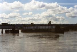
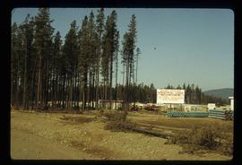
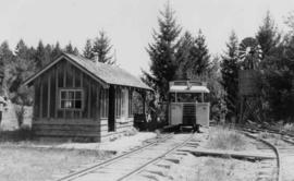
Showing 4434 results

Archival description
3211 results with digital objects Show results with digital objects
Quinson Elementary School
2012.13.2.16.02 · File · [2006?]
Part of J. Kent Sedgwick fonds

File consists of transcript of an oral interview with Trelle Morrow regarding the architectural development of Quinson Elementary School.

Quesnelle Forks Sign
2012.13.1.31.19 · Item · 1985
Part of J. Kent Sedgwick fonds

Image depicts Kent Sedgwick standing in front of a sign with a dog in Quesnelle Forks, B.C. The sign describes the history of the site, which began as a mining camp in 1859, but was later completely abandoned after a fire in 1866. It is now managed as a Forest Service Recreation Project.

2007.17.1.7 · Item · [ca. 1935]
Part of James Joseph Claxton Photograph Collection

Photograph depicts two wooden buildings in a snow covered forest environment. Photo is adhered to paper backing, upon which handwritten annotation on recto reads: “Quesnelle Quartz mining Company Hixon, B.C. Taken in mid nineteen thirties. Powerhouse from rear. Present day (1973) logging road would run through powerhouse at immediate rear of it at which you are looking. Tom Marsh Box 156 Squamish BC V0N 3G0 December 1978”

2007.17.1.6 · Item · [ca. 1935]
Part of James Joseph Claxton Photograph Collection

Photograph depicts two wooden buildings in a snow covered forest environment. Photo is adhered to paper backing, upon which handwritten annotation on recto reads: “Quesnelle Quartz Mining Co. Hixon BCTaken in mid 1930ies. Power house from rear. Present day (1973) Logging road would run through powerhouse at immediate rear of it at which you are looking. Tom Marsh Box 150 Squamish BC 1978.12”

Quesnel Quartz Mine Camp
2007.17.1.2 · Item · [ca. 1935]
Part of James Joseph Claxton Photograph Collection

Annotated overview of the Quesnel Quartz Mine Camp, with buildings numbered and a corresponding legend provided. Annotation on recto of photograph states: "1. BRIDGE OVER CREEK 2. BLACKSMITH SHOP 3. POWEROUSE 4. HEADFRAME OVER 200' SHAFT 5. OFFICE 6. WATER TANKS FROM POWERHOUSE 7. BUNKHOUSE 8. TRUCK 9. COOKHOUSE BEHIND #6 CANNOT BE SEEN" Additional annotation associated with photograph states: "We were always able to find the cookhouse even though hidden in this picture. Taken about 1935 by Russell Ross Supt. Quesnel Quartz Mine"

Queensborough bridge
2013.6.36.1.156.03 · Item · [July 1994]
Part of David Davies Railway Collection
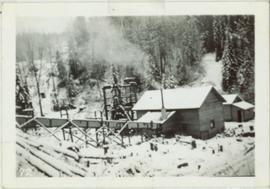
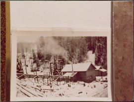
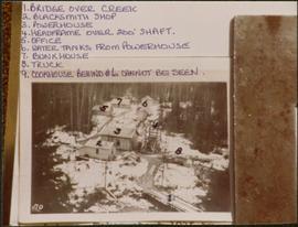
Photograph depicts railway track previously owned by BCER. It led onto the east end of Lulu Island and then to Annacis Island. Looking from the Naew West River Walk to the Queensborough bridge that was protected by signals and had a high chain link fence to deter pedestrians. It was likely that the rail was only used at night. Originally built by Canadian Northern Railway to reach Steveston, circa 1917.

Pulpmill
2012.13.1.3.142 · Item · Dec. 1997
Part of J. Kent Sedgwick fonds

Image depicts a pulpmill, likely Northwood, in Prince George, B.C.

Public Works
2009.6.13.24 · Subseries · 1974-1979
Part of The Honourable Iona Campagnolo fonds

Subseries consists of correspondence and accompanying informational material related to the Department of Public Works and construction and development initiatives. Records include speeches by the Minister of Public Works, news releases, notices of tender, brochure, memoranda, newspaper clippings, and reports. Includes correspondence regarding proposed developments, contracts for construction and renovation projects, Public Works housing, and requests and complaints directed to Public Works.

2000.1.2.5.1 · Item · October 13, 1953?
Part of Cassiar Asbestos Corporation Ltd. fonds

This blueprint shows the side profile of the proposed tramway at Cassiar. It includes relevant infrastructures and landscape features drawn and marked on the plan such as roads, monocable unloading stations, swamp and beaver ponds as well as streams. The side profile and schematics of the tramway are drawn in parts and includes relevant measurements. Locations of the unloading terminal, jig back towers and jig back loadind stations are included. The overall profile is split into two sections due to elevation changes and lack of drawing surface. Annotation written on the leading edge of the blueprint reads "J.A. Roebling - Proposed Tramway Layout".

2012.13.3.1.07 · File · 1983-1994
Part of J. Kent Sedgwick fonds

File consists of notes, clippings, and reproductions relating to proposed heritage buildings in Prince George. Includes: "A heritage to remember" typescript document prepared by the Prince George Joint Heritage Advisory Committee (Dec. 1983); "Heritage aspects of 886 Vancouver Street" typescript letter sent to Alderman Monica Becott from Kent Sedgwick (2 May 1991); and "House at 1677 - 7th Ave". typed letter to Ed Chanter from Kent Sedgwick (9 Sept. 1994). Also includes photographs depicting houses at the addresses 1651 Fifth Avenue, 1085 Vancouver Street, 983 Vancouver Street, 1675 Fifth Avenue, 1643 Fifth Avenue, 886 Vancouver Street, 1734 Twelfth Avenue (1991).