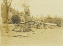
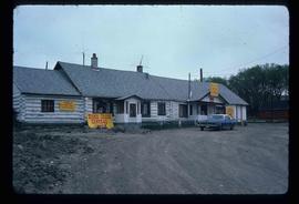
Photograph depicts a log cabin at Peace River with a dirt clearing in the foreground and a tree-covered environment in the background. Fist sign in images reads: "18 MLS to Rolla"; second sign reads: "Rolla Landing".
Image depicts a view of McBride in the Rocky Mountain Trench.
Photograph of a large crowd gathered at the McBride train station. Printed annotation on recto reads: "'Rocky Mountain Rangers Band, McBride, B.C.'"
Image depicts the peak of the Rocher de Boule mountain from Hazelton, B.C.
Image depicts an old log cabin with the sign "Robin Hood Flour" on it at an uncertain location. It is possibly at the 153 Mile House.
Image depicts a road with what appears to be a junkyard to the right of the image, likely located somewhere in Seton Portage, B.C.
Photograph depicts river winding through range of hills, bridge visible in distance.
Photograph depicts sternwheeler, smaller boat, and canoe in foreground. Second sternwheeler named the 'Caledonia' can be seen anchored to shore in background. Town buildings stand on hill in background. Photo believed to have been taken in Port Simpson, B.C.
Image depicts what appears to be a small, narrow river, and mounds of snow. The location is uncertain.
File consists of notes, clippings, and reproductions relating to the Ritts-Kiffer Hall on George Street in Prince George. Includes "..Dance.". program pamphlet (17 Mar. 1915) and various clipped articles from the Prince George Citizen newspaper.
Image depicts the "Riske Creek General Store" in Riske Creek, B.C.
Image depicts Riske Creek, B.C. The brown building on the left is the local school.
Image depicts the Esso gas station in Riske Creek, B.C.
Photograph depicts an unidentified man walking on path in front of Bishop Ridley's home. Several children can be seen in fenced yard in midground.
Handwritten annotation below image reads: "Ridley Home and Mission house Metlakahtla."; on verso: "Chapter XXVII / Heading for Chapter / Ridley Home Metlakahtla".
The item is a photograph depicting Rhein Gold at 1177 3rd Avenue, Lot 17, Prince George. Wooden building with "For Rent" sign in one window.
File contains slides depicting Revelstoke.
Handwritten annotation on recto of photograph: "RETAINING WALL POUR JULY 9/64." Photograph depicts construction workers among machinery near retaining wall under conveyor of crusher building. Crane stands on left, front end loader and back hoe tractor in foreground on right. Mountainside in background.
Handwritten annotation on recto of photograph: "RETAINING WALL POUR JULY 9/64." Photograph depicts two construction workers standing on retaining wall in foreground. Two other men stand near a crane operating in midground, with its load suspended above men on wall. Crane stands on road between a building and retaining wall, mountain range in background.
Handwritten annotation on recto of photograph: "RETAINING WALL POUR JULY 9/64." Photograph depicts large unidentified machinery in front of the retaining wall under conveyor of crusher building. Boom of crane can be seen in midground on right. Crusher building in background, dirt road in foreground.
Handwritten annotation on recto of photograph: "RETAINING RIBS JUNE 29/64". Photograph depicts construction workers on and near wooden framework structure extending from base of crusher building. Crane in background against mountainside. Miscellaneous construction equipment and materials throughout.
Image depicts the interior of a church in Shelley, B.C.
Image depicts the interior of the church after its restoration, in Shelley, B.C.
Overhead view of many residential buildings in Prince Rupert, BC. Veiled mountains are visible in the background. Printed annotation on recto reads: "'Residential Section' Prince Rupert. B.C. F. Button Photo. Prince Rupert. BC 119."
Photograph depicts building at 310 4th Avenue West, Prince Rupert in a residential neighbourhood.
Photograph depicts residential buildings along 4th Avenue east of Winnipeg Street. Annotation on verso: "series on s. side of, 4th east from Winnipeg, (railway houses)".
Photograph depicts residential buildings at 1662 and 1674 9th Avenue, one with a green roof and one with a metal roof. Annotation on verso: "1674 - 9th Ave green roof), 1662 - 9th Ave (metal roof)."
Photograph depicts a residential building in the North Thompson region.
Photograph depicts a residential building in the North Thompson region. The house is blue and surrounded by trees.
Photograph depicts a residential building at the corner of 6th Avenue and Winnipeg Street. Annotation on verso: "NE corner, 6th / Winnipeg".
Photograph depicts a residential building on the corner of Vancouver Street and 10th Avenue. Annotation on verso: "Trick house, Vancouver/ 10th".
Photograph depicts a residential building at 825 Vancouver Street. Annotation on verso: "Van Horlick c-7".
Photograph depicts a residential building at 1798 5th Avenue. Annotation on verso: "1798 - 5th Ave".
Photograph depicts a residential building at 1795 10th Avenue. Annotation on verso: "1795 - 10th Ave, SE corner of, Winnipeg".
Photograph depicts a residential building at 1770 5th Avenue. Annotation on verso: "1770 - 5th Ave".
Photograph depicts a residential building at 1722 7th Avenue. Annotation on verso: "1722 - 8th Ave".
Photograph depicts a residential building at 1661 10th Avenue. Annotation on verso: "1661 - 10th Ave".
Photograph depicts a residential building at 1651 5th Avenue. Annotation on verso: "1651 - 5th Ave".
Photograph depicts a residential building at 1648 8th Avenue. Annotation on verso: "1648 - 8th, next to Rosel's".
Photograph depicts a residential building at 1643 10th Avenue. Annotation on verso: "1643 - 10th Ave".
Photograph depicts a residential building at 1625 4th Avenue. Annotation on verso: "Loedel proposal, 1625 - 4th, (see above)".
Photograph depicts a residential building at 1617 8th Avenue. Annotation on verso: "1617 - 8th Ave".
Photograph depicts a residential building at 1616 8th Avenue, on the corner of Vancouver Street. Annotation on verso: "1616 -8th Ave, NW corner of Vancouver".
Photograph depicts a residential building at 1612 12th Avenue, the building was used as "Prince Realty". Annotation on verso: "1612 - 12th Ave., NW corner of Vancouver."
Photograph depicts a residential building at 1601 6th Avenue, the corner of 6th Avenue and Vancouver Street. Annotation on verso: "CUTE c-7, union, Vancouver/ 6th".
Image depicts a residential area with a playground somewhere in Mackenzie, B.C.
Photograph depicts a replacement rail bridge. Forms sat on a temporary pile of dirt, which in turns sat on a road bed of a new highway that had just been cut.
Photograph depicts a Rental and repair shop on 3rd Avenue.
Item is a photograph of the Reid Lake School.
Image depicts a building in Reid Lake