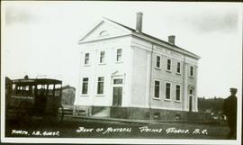
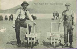
Two men standing beside wheelbarrows with signs that read: “Prince Rupert Transfer Co.” The men appear to be standing on large dock or boardwalk, water and hills in background. Printed annotation on recto reads: “Prince Rupert First Transfer Company.” Handwritten message in pencil on verso is addressed to “Mr. Gordon Penning 1600 Bld. Barclay Vancouver B.C.” Cancelation date on 1 cent Canadian Stamp is dated “Prince Rupert B.C. July 16, 09”.
Slightly elevated view of a street intersection on the edge of a slope in Prince Rupert. The "Canadian Bank of Commerce" is visible in the foreground. Printed annotation on recto reads: "Prince Rupert. British Columbia."
Street view of Third Avenue in Prince Rupert. One horse drawn delivery cart and one delivery car are parked on the street. Printed annotation on recto reads: "3rd Ave. Prince Rupert. B.C." Handwritten annotation on verso reads: "Book & parcel find[??] received, love & many thanks, u.w. as you know, just what I needed. [Illegible] R.W." Postcard is addressed to: "Mrs. J.W. Cawfsious [??] 1136 Barclay St. Vancouver B.C." Verso is affixed with a 2 cent Canadian Stamp, and is postmarked: "Prince Rupert B.C. Sep 19 6-PM."
Slightly elevated view of an intersection surrounded by residential and business buildings in Prince Rupert BC. Printed annotation on recto reads: "General View Prince Rupert. B.C. W.W.W."
Elevated photograph of downtown Prince Rupert covered in snow. Printed annotation on recto reads: "Winter Scene. Prince Rupert. B.C."
Street view photograph of several commercial buildings on an unidentified dirt road in Prince Rupert, BC. Foreground is primarily a shot of "Wallace's Dry Goods."
Elevated street view of Fulton Street in Prince Rupert, BC. City Hall is in the left foreground. Hills and water are visible in the background. Printed annotation on recto reads: "Prince Rupert. B.C."
Street view of Third Avenue in Prince Rupert, BC. Several cars are visible parked along the sides of the paved street. Printed annotation on recto reads: "Third Ave. W Prince Rupert- BC."
Hand coloured street view of Third Avenue in Prince Rupert, BC. Printed annotation on recto reads: "Third Avenue, Prince Rupert, B.C." Artist's mark in lower left corner reads: "109938 J.V."
Photograph depicts crowd and horses gathered in front of street building with the sign "The Northern Lumber Co Ltd."
Handwritten annotation on verso “Second St., South Fort George, 1912".
Photograph depicts tall building standing alone on street. Stage coach in left foreground, unidentified man in right foreground.
Handwritten annotation on recto: "BANK OF MONTREAL PRINCE GEORGE. B.C. PHOTO. I.B. GUEST.", on verso: “Bank of Montreal, 3rd & Quebec, Prince George. Built in 1919".
The pair stands among piles of boxes in what appears to be a warehouse.
Handwritten annotations on verso read: “lost election thanks to Otto Longs Transport decision to OK subsidy to North Coast Freight shipping,” and “Iona and storekeeper Werner Funk discussing freight costs, Queen Charlotte City, August / 77.”
Photograph depicts a street scent at the corner of Laselle and Second St. in Fort George. A wagon is visible in the dirt road and wooden buildings cross the mid ground. Three unidentified men sit on the boardwalk outside Rigg's Restaurant while one man stands in the doorway of The White Laundry.
Photograph depicts a group of buildings in distance behind fenced area. Field spans foreground and stand of trees in background. Handwritten photo caption below photograph reads: "H.B.C. Fort St. James ."
Postcard overview of several identifiable storefronts built amongst the rocky outcrops of Prince Rupert. Printed annotation on recto reads: "Prince Rupert BC."
Photograph depicts numerous copies of 'Stoney Creek Woman' (by Bridget Moran) in glass case. Display also features article on Mary John's receipt of the Order of Canada (see items 2008.3.1.22.61 and 2008.3.1.22.64 for photographs displayed in this image).
Photograph of residents in motion on Centre Street in Prince Rupert. Buildings are visible on either side of the street and a railway track runs down the length of the road. Annotation on recto reads: "Centre Street, Prince Rupert, BC. 1664."
Wide angle photograph of many buildings scattered in a clear cut area. Foreground shows several businesses, including "Kelly Carruther's Supply" and "Prince Rupert Hardware and Supply Co." Some remaining forest is visible in the background. Annotation on recto reads: "Prince Rupert, BC 1659."
View of the road descending to the waterfront. Buildings and forested area are visible on either side of street. Annotation on recto reads: "Prince Rupert BC. '07."
Photograph depicts Iona Campagnolo standing with a male worker in a yellow hat while on a tour of a fish cannery, possibly in Kitimat.
Photograph depicts Iona Campagnolo standing with two male workers while on a tour of a fish cannery, possibly in Kitimat.
Image depicts an abandoned building on the corner of a street in McBride, B.C. The faded letters on the side read: "McBride Trading Co. Mens Wear, Drugs, Equipment."
Image depicts a row of buildings in Upper Fraser, B.C. with the store (titled "Paradise") with a Pepsi sign. Map coordinates 54°07'09.1"N 121°56'47.0"W
Image depicts a street in Giscome B.C. The Giscome Store is located on the left side of the image with the church in the background. Map coordinates 54°04'18.5"N 122°21'57.7"W
Image depicts a snowy street in Willow River, B.C. There are several buildings, one is an Esso station and another is labelled as "Red & White Food Store."
Image depicts a street in Hudson's Hope, B.C.
Image depicts a street of businesses in Dawson Creek, B.C.
Image depicts a street of businesses and Mile "0" of the Alaskan Highway in Dawson Creek, B.C.
Image depicts a Chevron station as well as two motels in Chetwynd, B.C.
Image depicts the Station Museum and the "Alberta Pool Elevators Ltd." building in Dawson Creek, B.C.
Image depicts 3rd Ave at Victoria St. Map coordinates 53°55'03.9"N 122°44'54.8"W
Image depicts Central Street West, parallel to Highway 97 in Prince George, B.C. looking north. Shown: Prince George Motors and other car dealerships, Burger King, Grama's Inn, and the Spruceland Shopping Mall sign. Map coordinates 53°54'42.1"N 122°46'53.1"W
Image depicts the Wake Up Jake Saloon in Barkerville, as well as several other buildings.
Image depicts the interior of the historic Hudson's Bay Company Trading Post in Fort St. James, B.C.
Image depicts the interior of the historic Hudson's Bay Company Trading Post, with several unknown individuals present, in Fort St. James, B.C.
Image depicts what appears to be a motel somewhere near Bralorne, B.C.
Image depicts the "Riske Creek General Store" in Riske Creek, B.C.
Image depicts the Bank of Montreal in Prince George, B.C.
Image depicts a street of businesses, possibly 3rd Avenue, in Prince George, B.C.
Image depicts numerous businesses, such as the Bay, Overwaitea, and Dairy Queen, somewhere in Kitimat, B.C.
Image depicts a hotel in Likely, B.C.
Image depicts numerous vehicles parked outside a building with a sign which reads "Mackenzie Centre;" it is possibly the mall in Mackenzie, B.C.
Image depicts the gas station at Manson Creek, B.C.
Image depicts the interior of a mall in Prince Rupert, B.C. It is possibly the Pride O' the North shopping mall.
Image depicts the Pride O' the North shopping mall in Prince Rupert, B.C.
Image depicts the main street of Stewart, B.C.
Image depicts several buildings along the main street in Stewart, B.C.
Image depicts the abandoned and crumbling Forman's General Store somewhere in or near either Barkerville or Wells, B.C.
Image depicts the original bank building in Wells, B.C.