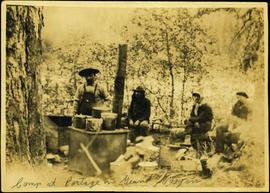
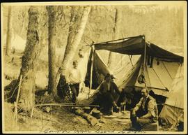
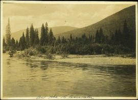
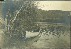
Showing 433 results

Archival description
365 results with digital objects Show results with digital objects
2009.5.3.18 · Item · [ca. 1913]
Part of Taylor-Baxter Family Photograph Collection

Photograph depicts Mr. Barnett seated in floating canoe tied to tree on shore. Forest on opposite shore in background. Handwritten annotation on verso of this photograph reads: "Billy Barnett". It is speculated that this photograph may have been taken on the Fraser River near Giscome Portage, B.C.

Board of Directors
2000.1.1.4.3 · File · ca. 1951 - ca. 1960
Part of Cassiar Asbestos Corporation Ltd. fonds

File contains photographs featuring members of the Board of Directors of Cassiar Asbestos Corporation Ltd., which was formed on the 17th of May, 1951. Cassiar's forerunner was a company named Conwest, formed in 1534, a consolidation of two companies owned by Fred Martin Connell and his brother W. Harold Connell. The first board of directors included the Connell brothers, George Armstrong, John E. Kennedy, Charles & Arthur Mortimer, and Charles Rainforth Elliot (chartered accountant and secretary-treasurer of Conwest & Cassiar). Directors depicted in this file include F.M Connell, Harold Connell, Charles Elliot, John E. Kennedy, George Armstrong, Ken A. Creery, John Drybrough, Tam Zimmermann, George Washington Smith (president of Bell Asbestos Mines), Nick Gritzuk, Jack Christian (general manager, president, and CEO). Other individuals depicted include Fred Murry, Andre Beguin, Plato Malozemoff from Newmont Mining (co-founder of Cassiar with F.M. Connell), Alfred Lloyd Penhale (founder and CEO of Asbestos Corporation of Canada Ltd.), C.B. Brown, Pierre Marcotte, Francis Parker Smith (brother of George Smith), Bill Oughtred, Bill Johnson, and a Mr. Janitsch. File also includes a portrait of an unidentified director of Cassiar from Turner and Newall in England, taken at the corporate club in Toronto. Group portraits were taken at the Cassiar Valley, the office building, "House 130," fishing outings, and at formal events in unidentified locations.

2000.13.1.85 · Item · 1976.
Part of Ray Williston fonds

Item is a photograph of the Board of Directors of the British Columbia Cellulose Company. Pictured from left are: Mr. Harvey of Plateau Mills, Ted Vezak of Ocean Falls Corporation, Ken McKenzie, Ray Williston, John Liersch, Jack Sigalet of Kootenay Forest Products, Ian Mahood, and Don Watson.

Bob Harkins fonds
2001.12 · c.1953 - c.2000

Fonds consists of textual records, photographic items and published reports related to professional life and career of Bob Harkins, broadcaster, local historian, and former city councilor. Includes textual and photographic items related to development and history of city of Prince George and the Central Interior of BC region history and development in late 20th century. Items includes an unpublished manuscript on the life of Ray Williston by Eileen Williston, an unpublished paper on the history of technological change in logging industry; an unpublished paper on the history of radio and television in Prince George; a report related to the creation of a university for Northern British Columbia (1989) and proofs of the publication "Wild Liard Waters: Canoeing Canada's Historic Liard River" by Ferdi Wenger, c.1998. Also includes photographic files including CKPG Radio Studio photographic items c.1953; and photographs and correspondence regarding guide outfitter Skook Davidson c.1975.

Harkins, Bob
2011.12.25 · Item · [ca. September 1950- June 1951]
Part of Giscome, BC Historical Photograph collection

Photograph of the front of Brown's General Store. Handwritten annotation in pen on verso reads: “Brown’s General Store. The wheelbarrow is for bringing the groceries and mail over from the train. Also if you buy a great quantity of things you wheel it home and then bring back the barrow (Taken on Sunday).”

2012.13.1.87.067 · Item · [between 1975 and 1995]
Part of J. Kent Sedgwick fonds

Image depicts a row of buildings in Upper Fraser, B.C. with the store (titled "Paradise") with a Pepsi sign. Map coordinates 54°07'09.1"N 121°56'47.0"W

2009.5.2.88 · Item · 1899
Part of Taylor-Baxter Family Photograph Collection

Photograph depicts group of men in hats and ties standing on wood deck connecting four store fronts. Left to right: Parsons Produce Co., Dunn & Co. Hardware and Tinware, Fortin & LeGappelain Druggists, Cummings & Richardson - Gents, Furnishings, Boots and Shoes. Handwritten annotation on recto of photograph: "Branch Parsons Produce Co at Atlin 1899."

Businesses
2012.13.1.7.250 · Item · [2003?]
Part of J. Kent Sedgwick fonds

Image depicts a street of businesses, possibly 3rd Avenue, in Prince George, B.C.

2011.3.2.20 · Item · [ca. 1910-1924]
Part of North Coast & Central BC Postcard Collection

Street view photograph of a commercial section in downtown Prince George with several "Campbell's" delivery carts parked along the road. Visible establishments include "Campbell's All Cash Store" and "Club Cafe." Handwritten annotation in blue ballpoint pen on recto reads: "Howdy from Prince George! Going easy with all these kids- good to see Kathee. Snow here. Have fun at the sports show & don't over do it. Thinking of you guys, love Judy and Vic. P.S. Can't wait to go home to somewhere peaceful and quiet. 2-27-83." Postcard is addressed to: "Mr. & Mrs. Hauffer 8429-221 PL. Sn. Edmonds, WA. U.S. 98020." Verso is affixed with four Canadian 8-cent stamps.

Carson Avenue, Quesnel, BC
2011.3.1.16 · Item · ca. 1930
Part of North Coast & Central BC Postcard Collection

Street view photograph looking down Carson Avenue at the Front St. intersection in Quesnel, BC. Several identified businesses line the gravel avenue on the right; however Cowan's Hardware store is visible at the intersection on the left. Printed annotation on recto reads: "Carson Ave., Quesnel, B.C. 1930 Looking East."

2011.3.2.09 · Item · 1913
Part of North Coast & Central BC Postcard Collection

Printed annotation on recto reads: “Central Avenue Fort George B.C. Copyright Canada June 25th 1913”. Handwritten annotation in ink on recto reads: “Hotel Fort George; Pool room; Men’s furnishing; General store; Bank Vancouver; Telephone office; Temperance House; Trust-company; Grand stand & fair grounds; Hospital; Ware house and general store.” Cancelled 1 cent Canadian stamp on verso is dated: "Fort George BC Jul 14 13". Handwritten message in ink on verso is addressed to Mr. Chas H Wilson 94 Gould St Toronto: "Fort George. B.C> Box 65, July 13/ 13. Dear Father, This is a 'bird's eye view' of our main street - ha! ha! some class alright. We live right behind the bakery lunch room on the right hand side of the picture, on 1st avenue, some people eh? Will be moving to Cassiar Ave soon. How are all the folks. Mae is writing. Peace. M."

Central Business District
2012.13.1.3.057 · Item · July 1979
Part of J. Kent Sedgwick fonds

Image depicts the Central Business District of Prince George looking north from Connaught Hill. Map coordinates 53°54'41.4"N 122°44'58.5"W

2012.13.3.1.10 · File · 1966-2006
Part of J. Kent Sedgwick fonds

File consists of clippings, notes, and reproductions relating to the central business district of Prince George. Includes: "Tours of downtown" pamphlet from the Prince George Public Library (6 July 2006); "Mr. P.G. says welcome to the city of Prince George" promotional map from the City of Prince George and drawn by H. Kettner (1966); "Re: Pcl. A (Lots 19-20)" typescript letter from BC Rail to Kent Sedgwick (2 Dec. 1987); "Prince George Public Library" letter from Tom Dielissen at the Prince George Public Library to Kent Sedgwick (2 July 1997); "Town Centre Historical Project" letter to the Mayor and Council of Prince George from Daniel Guerrette (16 July 1981); and "Historical continuity and the proposed town centre" typescript document submitted to City Council from the Heritage Advisory Committee (July 1981). File also includes photographs depicting the industrial area of Prince George (1987).

Central Street West
2012.13.1.3.115 · Item · 12 Oct. 1989
Part of J. Kent Sedgwick fonds

Image depicts Central Street West, parallel to Highway 97 in Prince George, B.C. looking north. Shown: Prince George Motors and other car dealerships, Burger King, Grama's Inn, and the Spruceland Shopping Mall sign. Map coordinates 53°54'42.1"N 122°46'53.1"W

Centre Street Prince Rupert
2009.7.1.251 · Item · ca. 1880-1920
Part of Archdeacon W. H. Collison fonds

Photograph of residents in motion on Centre Street in Prince Rupert. Buildings are visible on either side of the street and a railway track runs down the length of the road. Annotation on recto reads: "Centre Street, Prince Rupert, BC. 1664."

2009.5.3.24 · Item · [ca. 1914]
Part of Taylor-Baxter Family Photograph Collection

Photograph depicts four men standing near fully packed horse-drawn cart in front of wood buildings, including a long building with a porch and chairs. Trees on hill visible in background. Handwritten annotation on recto of photograph: "Changing teams on the Cariboo Road".

2000.1.1.4.3.01 · Item · [ca. 1951]
Part of Cassiar Asbestos Corporation Ltd. fonds

Photograph depicts close view of four men in formal attire holding beverages while having a discussion. Left to right: Jack Christian (President Cassiar), Fred Martin Connell (Chairman and Chairman of Conwest Exploration Company Limited), W. Harold Connell (older brother of FM and Director of Conwest), and Charles Rainforth Elliot (Director and President of Conwest Exploration). Framed painting visible on wall in background.

2000.1.1.4.3.02 · Item · [ca. 1951]
Part of Cassiar Asbestos Corporation Ltd. fonds

Photograph depicts close view of four men in formal attire holding beverages while having a discussion. Left to right: Jack Christian (President Cassiar), Fred Martin Connell (Chairman and Chairman of Conwest Exploration Company Limited), W. Harold Connell (older brother of FM and Director of Conwest), and Charles Rainforth Elliot (Director and President of Conwest Exploration). Framed painting visible on wall in background.

Clearwater River, BC
2009.5.3.4 · Item · [ca. 1913]
Part of Taylor-Baxter Family Photograph Collection

Photograph depicts opposite shore in background behind river, and close shore in foreground on right. Men can be seen standing and paddling on canoe in distance. Handwritten photo caption on verso and recto of this photograph reads: "On the Clearwater".

Clinton Creek Operations
2000.1.1.3.20 · File · 1961 - [ca.1975]
Part of Cassiar Asbestos Corporation Ltd. fonds

Cassiar Asbestos Corporation Ltd opened a second mine in 1967 at what became the one-industry town of Clinton Creek, Y.T. File contains photographs depicting different areas of operations at Clinton Creek. Locations include the mine, plant, town, tailings pile, main office, the 40 Mile River, and surrounding area. Town photos depict the grocery store, cafeteria, medical clinic, school, auditorium residential area, Connell Street and power house. File also includes aerial photographs and images depicting forest fighting, photographers capturing the tailings pile, asbestos samples, mining machinery, staff offices, and operations in the mill, lab, and garage.

Additional photographs integrated into file depict Clinton Creek's surrounding area, and three slides of a tailing pile explosion believed to be Clinton Creek.