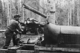
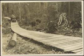
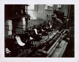
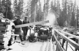
Photograph depicts workers cutting timber with a lomen planer at Peden Hill sawmill.
Photograph depicts a male worker operating a gin pole, winch and jammer to hoist logs onto a logging truck at Peden Hill sawmill.
Item is a photograph of a worker operating a Chip-n-Saws.
Photograph depicts a male worker standing amid stacks of lumber in a lumber yard at Peden Hill sawmill.
Handwritten caption beside this photo reads: "Work crew eating in open at 10˚ below zero, evicted from Lunchroom, due to damage to, from falling rock." Men are shown sitting in snow. Various metal materials in foreground, snow-covered mountainside in background. It is believed that power lines are also visible in background.
Photograph depicts two similar wood structures built into mountainside in snowy area. Unidentified machinery in foreground on far left. Power lines or other cables above in background.
Photograph depicts wood planks piled on a dock with wood buildings built along the shoreline of the background.
Fully loaded logging truck driving along a wood plank logging road. Another road under construction is also visible through forest in background.
Handwritten annotation in pencil on verso reads: “Logging - Giscome B.C. Plank truck road - also road under construction showing sills & cribbing."
Three unidentified women lean over flowing stream in area speculated to be a mining location. Sluiceway appears to be visible in foreground.
Unidentified woman holds pan in area speculated to be a mining location. Steel drums stand behind her, road and grassy hillside in background.
Map depicts the area around Wilkinson Creek near Carmi, BC. Annotated by Davies to show the Kettle Valley Railway.
Photograph depicts a wharf and buildings along the shore of an unidentified fishing community with a forested environment visible in the background.
Handwritten annotation on recto of photograph: "FOOTING WEST WALL AUG 8/64." Photograph depicts a construction worker near freshly poured cement footings. Building is semi-visible in background on left, tall steel framework behind footings on right. The hard had of a second worker is visible behind footings.
Handwritten annotation on recto of photograph: "WEST WALL FOOTING AUG 8/64." Photograph depicts a construction worker standing on rebar in forms built for cement footings. A front end loader and backhoe tractor can be seen on wood platform above footings. Mountainside in background.
Photograph depicts the West peak of the Cassiar mine, pit partially visible below. Drill visible in left foreground at highest elevation of mine, north west mountain range in background.
Photograph depicts the West peak of the Cassiar mine, pit partially visible below. Mining equipment barely visible in foreground at highest elevation of mine, north west mountain range stands in background, and mine valley crosses midground.
Collection consists of a 50th anniversary video about the history of the West Fraser Timber Company Ltd.
This West Fraser Timber Company Ltd. 50th anniversary video covers the history of the company through interviews, narration, and historical images.
Publication is entitled "West Coast Oil Ports Inquiry Statement of Proceedings", a summary of the proceedings of the inquiry commissioned by the Government of Canada into oil tanker ports and tanker traffic on the Canadian west coast.
Photograph depicts an unidentified individual wearing a welding helmet, and kneeling behind large bearing cups of one of the Ruston Hornsby diesel engines that turned the generators in the power house on the Cassiar plant. Door, bulletin board, and miscellaneous supplies in background.
Map depicts the city of Richmond and Lulu Island, including rail trackage.
Photograph depicts piles of wood planks and log booms in the foreground with a waterfall in the background.
Photograph depicts white rapids at bottom of waterfall in Bulkley River, B.C. Fishing territory visible on far right; hill on opposite shore in background.
Contour plan shows layout of a water tunnel near Lyon's Creek in the CNR Clearwater subdivision.
Photograph depicts an unidentified man standing to left of large puddle in gravel pit, mountain peaks in background. Photo speculated to have been taken on the plant, or near the Cassiar airstrip, facing south west. Stamped annotation on recto of photograph: "JUN. 1987".
File contains 3 strips of negatives depicting water control structures inluding pipes, culverts, and holding ponds. The strips were found in a photo lab pouch annotated "Sedimentation Pond Sept 1991" and addressed to "Cassiar Mining Corp. Attn; R. Tyne."
Photograph depicts benches of Cassiar's open mine. Men can be seen standing near machinery speculated to be blasthole drills in bottom left of image. Handwritten annotation on recto of photograph: "Waste Stripping Operations on McDame Mt. Ore Mining in lower right Corner.", on verso: "1961".
Photograph depicts large swath of dark waste down mountainside to right of valley. The waste dump is believed to be visible at top of swath on right of image. Bench mining visible on the North and South peak in background. Handwritten annotation on recto of photograph: "Oct. 25 / 65 4:25 PM."
Photograph depicts Wabco in left foreground in front of shop building, tractor, and miscellaneous supplies. Mine valley and mountains in background. Handwritten annotation on recto of photograph: "Cassiar B.C. 1970 June 23 by Tom Kiefer".
Photographs from Cassiar trip report to Ditton Works, a pipe division of TAC Construction Materials Ltd. Asbestos pipe was made at this particular factory. The company used some Cassiar fibres in their production. Labelled appendix I, this collection includes: photographs of equipment, bagging, packaging, fibre, pipes, and screens from inside the factory.
Photographs from Cassiar trip report to Demona plant of Friction Materials Corporation in Israel. This plant makes only brake linings and they use a blend of blend of fibre and rayon in production. Labelled Appendix J, this collection includes landscape photos of the plant.
Photographs from Cassiar trip report to R.C. quarry plant in Sweden. This plant utilized rubber type dust enclosures to maintain low dust levels. Labelled Appendix F, this collection includes: landscape photograph of quarry, seal to conveyor gallery, rubber lined truck, rubber seal on equipment, rubber cover screen, and rubber bucket elevator.
Violet sits wearing a fur coat next to younger brother Dixon who wears a suit and hat. They are seated in unidentified area on a wood structure between tall piles of planed lumber. A tall shelter can be seen behind them, and forest trees in background. Dixon Taylor worked at the sawmill in Penny, BC.
Book was published by The Allen Photo Co., of Prince Rupert, B.C. and features printed photographs and captions documenting various aspects of Prince Rupert development from 1908 to 1910.
Handwritten caption beside this photo reads: "Sumit Lake." Trees can be seen on shore jutting into the lake on left, as well as on opposite shore in distant background. Unidentified objects can be seen in distance, possibly buildings on far shore.
Photograph depicts a view of a steam donkey probably at Sayward near Kelsey Bay on North Vancouver Island.
Handwritten caption beside this photo reads: "View of Pinion & three sections of Crusher". Red rectangular equipment stands enclosed in wood frame, which is also enclosed in the much larger steel frame of the crusher building. Traveler crane on right.
View of town on shore, from above. Boats docked along piers and buildings. Hills visible on either side of water in background.
Handwritten photo captions with arrows pointing to sections of image read: "General Merchandise", "Fort Wrangell Hotel".
Photograph depicts the steep slope of man-made embankment. Forest in background, level excavated ground in foreground.
Photograph depicts the steep slope of man-made embankment, forest in background at bottom of slope. Small twigs and pant leg of unidentified individual in foreground.
One man can be seen on crusher building framework, unidentified equipment and long metal rods in foreground. Power lines, a large tank, and other small buildings are semi-visible on a level in the mountainside just above the crusher building. Sky can be seen in background.
Men can be seen working on site. Crusher building in midground, chutes can be seen crossing the different levels of foundation. Lumber is leaning against excavated dirt wall in foreground, as well as a ladder which reaches up to the base level. Large tank can be seen in top level above building construction. Mountaintop and sky in background.
View showing various levels of foundations. Men can be seen working on site. Vertically protruding planks from framework in foreground. A long building believed to be housing conveyor "B" can be seen in background, as well as the tree-covered valley.
View facing into mountainside and showing various levels of foundations. Men can be seen working on site. Unidentified machinery and pile of long metal rods in foreground.
Men can be seen working on site, building tools and supplies scattered throughout. Handwritten caption beside this photo reads: "View showing various levels of foundations". A chute of some kind extends from high level to men near bottom. Dirt road at site, and tree-covered valley can be seen in background. Construction of a long structure near the edge of the excavation area can be seen in midground; this is believed to be conveyor "B".
Photograph depicts a view of cannery buildings from the shoreline with mountains in the background.
Handwritten caption beside this photo reads: "View of Bin and Pan Feeder". Interior view of crusher building. A square, snow-covered object is being lowered by crane into building.
Photograph depicts snow-plowed road in foreground, Cassiar mountians in background. Road is lined with trees and power poles, and vehicle is visible in distance. Handwritten annotation on recto of photograph: "Looking west from townsite".
Water level photograph of several vessels docking in Prince Rupert. The "Co Op Fish Liver Oil" building is visible in the background. Printed annotation on recto reads: "Docks Prince Rupert."
Handwritten annotation on recto of photograph: "ASBESTOS FIBRE VEINS AS THEY OCCURR IN A ROCK FACE". Photo caption under printed copy of image in 1952 Annual Report: "North Wall of adit approximately 225 feet from portal showing asbestos veinlets."