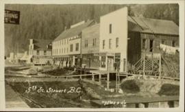
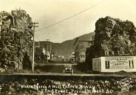
Handwritten annotation on recto of postcard reads: “Were there’s a will there’s a way, 5th Street, Prince Rupert, B.C., F. Button photo Pr. Rupert. No. 514.” Handwritten annotation in pen on verso of postcard reads: “Miss Belding, 33 Marlbro Avenue, Hull Yorkshire, England. S.S. Prince George. Dec. 1918. Dear Bertha, This is a street in the centre of the town Prince Rupert. There is a capacity list of passengers on board. The boat is registered to hold 384. We left at midnight and exped to arrive in Vancouver tomorrow at 3:30 pm. Love from Edie.”
Street view photograph of the construction of 5th Street in Stewart, BC. Visible businesses include the "Hotel King Edward" and "Empress Theatre." Printed annotation on recto reads: "5th St. Stewart B.C. Hughes #46."
Photograph depicts a stage coach harnessed with six horses, a fence and a log building in the background.
Photograph depicts four men bathing in a backwater or lake. One clothed man stands on the shore.
Photograph depicts two men wading and bathing in shallow water with lily pads.
Photograph depicts three men standing on the banks of a backwater or lake, with clothing piled on the ground.
Image depicts a bear, possibly a grizzly. The location is uncertain.
Image depicts a truck on a bridge, possibly crossing over the Peace River.
Elevated view of various buildings and vessels along the Prince Rupert waterfront. Several piles of lumber can be seen in the foreground. Printed annotation on recto reads: " Prince Rupert B.C., A busy day on the Waterfront."
Image depicts a camper and a man and woman at an uncertain location, possibly somewhere near Meldrum Creek, B.C. The woman in the image is Sue Sedgwick.
Photograph depicts open fields, cleared land, rolling hills and a river. There is a fence across the middle of the field and a building near the riverbank.
Image depicts a church at an uncertain location.
Image depicts a cow at an uncertain location.
Image depicts a creek somewhere near Bralorne, B.C.
Image depicts what appears to be a ferry crossing a river at an uncertain location.
Photograph depicts A. H. Holland standing under a tarp with a border collie dog. A pile of firewood is also under the tarp.
Image depicts a stretch of highway, possibly Highway 29 or 97.
Image depicts a horse on Cottonwood Island.
Image depicts a hotel in what appears to be a small community, possibly an outlying area of Bralorne, B.C.
Image depicts three people standing at the front door of a house at an uncertain location.
Image depicts a lake in South Tweedsmuir Provincial Park.
Image depicts a lake in South Tweedsmuir Provincial Park. There is an unknown individual present in a canoe with the camera-man.
Image depicts a lake in South Tweedsmuir Provincial Park.
Image depicts a lake in South Tweedsmuir Provincial Park. There is an unknown individual present in a canoe with the camera-man.
Image depicts an aerial view of a lake in South Tweedsmuir Provincial Park.
Image depicts a lake in South Tweedsmuir Provincial Park. There is a canoe present on the shore.
Image depicts a lake in South Tweedsmuir Provincial Park.
Image depicts a lake in South Tweedsmuir Provincial Park. An unknown individual is walking along the shore.
Image depicts a lake at an uncertain location.
Image depicts a lake somewhere near Mt. Robson; it is possibly Kinney Lake.
Image depicts what is possibly Melita Lake. The mountain in the background is possibly Tseax Cone, the volcano responsible for the existence of the Tseax lava flow.
Image depicts an elevated view of a lake and a road located somewhere near Bralorne, B.C.
The map of Canada is part of a greater booklet on Canadian history. This booklet was intended to help those preparing for their Canadian citizenship interview.
Image depicts a man on the hiking trail near Mt. Robson, with a river in the background; it is possibly the Robson River.
Photograph depicts a man in uniform and a woman posing for a photo on a road situated between a fenced area featuring totem poles. Along the water’s edge in the background there is a float plane, wharf and the Camosun vessel. Handwritten annotation on verso reads: “Alert Bay B.C. Union Steamships Ltd.”; “Alert Bay BC”; photographer’s stamp on verso states: “W.E. Nicholson, 268 E. 10th, Vancouver 10, B.C.”
Image depicts what appears to be a motel somewhere near Bralorne, B.C.
Image depicts a mountain peak, possibly Mt. Robson.
Image depicts a mountain, possibly Mt. Robson.
Image depicts a river in South Tweedsmuir Provincial Park. There is an unknown individual present in a canoe with the camera-man.
Image depicts what appears to be a type of log bridge crossing a river somewhere on Haida Gwaii.
Image depicts a road somewhere in Tumbler Ridge, B.C. There are three bush planes in the image.
Image depicts a road somewhere in Tumbler Ridge, B.C.
Image depicts a road somewhere in Tumbler Ridge, B.C. There are numerous construction vehicles present.
Image depicts a saw and numerous wooden boards at an uncertain location.
Photograph depicts a view from Billing siding toward a river with mountains behind.
Image depicts what appears to be a shed at an uncertain location.
Image depicts a street in Island Cache.