Map depicts passenger routes on the Canadian Pacific Railway and its connecting lines in 1925.
Tourist map of Prince George depicts city area, including railway trackage.
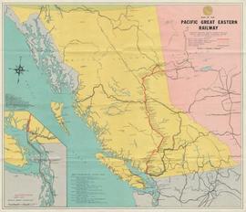
Map depicts the routes of the Pacific Great Eastern Railway, showing stations, railway connection, and the PGE Microwave Communication System.
Map depicts the city of Kelowna and area. Annotated by Davies to emphasize rail lines.
Map depicts the area around Wilkinson Creek near Carmi, BC. Annotated by Davies to show the Kettle Valley Railway.
Subseries consists of cartographic material separated from Campagnolo’s government textual record files. Includes government maps of British Columbia created by the Department of Energy, Mines and Resources Surveys and Mapping Branch; tourist road maps of BC, Prince Edward Island, Corner Brook, and Regina; maps relating to the oil and gas industry; maps of site plans for proposed developments; and a map of Edmonton for the XI Commonwealth Games.
Map depicts existing oil lines, oil lines proposed or under construction, product lines, existing gas lines, gas lines proposed or under construction, LPG lines, and LPG lines proposed in Canada and Northern USA.
Map depicts the Coast of British Columbia and Federal and Provincial proposed fishing boundaries, including the 200 mile limit.
Tourist map of Corner Brook, Newfoundland depicting the various parks, streets and attraction centres.
Subseries includes research material created and collected by Kent Sedgwick relating to the incorporation of the City of Prince George. Topics include the naming of the City of Prince George, city boundaries, the city amalgamation with Fort George and South Fort George, city census records, and mayors of Prince George.
File consists of photocopies and notes relating to the boundary expansions of the city of Prince George since its incorporation. Includes a graph drawn by Kent Sedgwick regarding the addition of land and water each year of the boundary expansion and a "Proclamation" photocopy from the B.C. Gazette (23 Apr. 1953). Also includes 5 maps: "City of Prince George Boundary Expansions since Incorporation in 1915" (1979 or 1980); "City of Prince George" (Feb. 1979); "Map of Prince George" (between 1970 and 1985); "Study Area Boundaries" (Mar. 1977); and "City of Prince George" (Feb. 1972).
Subseries includes research material created and collected by Kent Sedgwick relating to land survey, development, and settlement in Prince George and British Columbia. Land surveys were conducted in British Columbia by surveyors George Dawson, the North Coast Land Company, Alfred R.C. Selwyn, and the Geological Survey of Canada during the late 19th and early 20th centuries. James C. Anderson and engineer J. Gill conducted topographical surveys for the Grand Trunk Pacific Railway on Fort George and the Indian Reserve. Surveyors and land plot companies developed the land for sale to promote settlement in the area. Also includes materials regarding the continued development of the City of Prince George throughout the 20th century. The files primarily consist of newspaper clippings, research notes, and photocopied documents.
File consists of maps and town surveys of early Prince George. Includes various reproduced 1915 maps and surveys depicting Prince George, Central Fort George, and Fort George: "Subdivision of part of Indian Reserve no. 1 lot 343 Cariboo District BC"; "Parcel Z map 1268"; "Plan of Subdivision lot 933"; "First addition to townsite of Central Fort George"; "Subdivision of lot 1511 Cariboo District BC"; "Townsite of Fort George" map originally made by R.H. Holland; "Plan of Subdivision of lot 1426 Fort George Collins Addition"; "Plan of subdivision of lot 932 Cariboo District"; and "Plan of subdivision of part of lot 2507."
The item is a reproduction of a survey map drafted in January 1910. The reproduction was likely created in 1990. The subdivision is Lot 936 G. I. Cariboo District, B.C. The area covered is North of Twenty First Avenue, East of Quinn Street, South of Eighth Avenue and West of Carney Street. Annotations highlight "Owner Edgar McMickiny," "696" and "Jordan Brothel" written in red pen pointing to a specific location.
The item is a reproduction of a survey map drafted in September 1909. The reproduction was likely created in 1990. The annotations highlight owners of different lots up to approximately 1959. Th area covered is North of Fifteenth Avenue, East of Irwin Street, South of Eighth Avenue and West of Carney Street. Annotations on attached papers indicate different means of scale and measurement for the map.
The item is a reproduction of a survey map likely drafted in the 1910s. The reproduction was likely created in 1990. The area covered is South of Anderson Street, East of Simpson Street, North of Van Bien Avenue and West of 9th Street. Annotations state, "Pl 721 DL 1426."
The item is a reproduction of a survey map drafted on 1 March 1910. The reproduction was likely created in 1990. The area covered is South of Bernhardt Avenue, East of Simpson Street, North of the Fraser River and West of 9th Street. Annotations state, "DL 1426 Plan 721."
The item is a reproduction of a survey map drafted in 1909. The reproduction was likely created in 1990. The area covered are lots 931 and 417. Annotations state, "Plan 701," and various names are highlighted.
Collection consists of 1 map of "Status of Sustained-Yield Forestry Programme as at December 31, 1969" by British Columbia Department of Lands, Forests, and Water Resources and 10 pages of handwritten instructions for opening a ranger station in Smithers and annual Forest Insect and Disease Survey, dated 1980.
File consists of maps depicting the Salmon River Portage area.
The item is a map depicting the Salmon Portage area along the Salmon River. Various annotations are written in pen and sections of the map are coloured with pencil crayon. The Forest Cover Map identification number is 93J.027.
The item is a map depicting the Salmon Portage area along the Salmon River. Various annotations are written in pen and sections of the map are coloured with pencil crayon. The Forest Cover Map identification number is 93J.026.
Item is a photocopy of a topographical map published by the Grand Trunk Pacific Railway depicting Fort George and Indian Reserve No.1 and the surrounding area.
Item is an original map depicting biogeoclimatic units of the Prince George Forest Region published by the British Columbia Ministry of Forests.
Item consists of three maps pieced together to depict Anahim Lake, Bella Coola, and Quesnel in British Columbia originally published by the Department of Lands, Forests and Water Resources in Victoria B.C.
Item is an original map depicting British Columbia and its road networks, published by the Province of British Columbia Ministry of Environment.
Item is an original map depicting biogeoclimatic zones of British Columbia published by the Ministry of Forests in Victoria, British Columbia.
Item is a photocopied 1944 map depicting Fort George, published by British Columbia Department of Lands.
Item is an original 1943 pre-emptor's map of Fort George, published by the British Columbia Department of Lands.
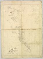
Item is an original 1879 map depicting northern British Columbia and the Peace River Country, created by G.M. Dawson and published in Geological Survey of Canada Report B 1879-80.
Item is an original 1976 map depicting the Prince Rupert and Terrace area in British Columbia, published by the Department of Environment in Victoria, British Columbia.
Item is an original 1969 map depicting Taseko Lakes in British Columbia, published by the Department of Energy, Mines and Resources in Ottawa Canada.
Item is an original 1969 map depicting Bonaparte Lake in British Columbia, published by the Department of Energy, Mines and Resources in Ottawa Canada.
Item is an original 1969 map depicting Prince George British Columbia, published by the Department of Energy, Mines and Resources in Ottawa.
Item is an original 1986 map depicting the Peace River to Liard region of British Columbia, published by the Outdoor Recreation Council of British Columbia.
Item is an original 1980 map depicting travel and recreation across northwestern British Columbia, published by the Canadian Cartographers Ltd. in Coquitlam, BC.
Item is an original map depicting tourism in southwestern British Columbia published by the Province of British Columbia Ministry of Tourism.
Item is an original 1970 map of British Columbia with annotations of Kent's travels throughout the province highlighted in yellow. The map was originally published by the Department of Lands, Forests and Water Resources in British Columbia.
Item is an original map depicting provincial parks across northern British Columbia and was published by the British Columbia Department of Lands, Forests and Water Resources. The map includes pen marks and highlighting.
Item is an original 1983 map depicting Atnarko River in British Columbia, published by the Province of British Columbia Ministry of Environment.
Item is an original 1989 map depicting Anahim Lake in British Columbia, published by Energy Mines and Resources Canada.
Item is an original 1996 folding brochure map depicting circle tours in the Prince George area. The map was published by the Prince George Region Development Corporation.
Item is an original map depicting the city of Prince George and its parks and trails. The map was published by the City of Prince George Leisure Services.
Item is an original 1985 map depicting Red Rock area of British Columbia, published by the Department of Energy, Mines and Resources. The map includes pen markings.
Item is an original 1961 map depicting Giscome in British Columbia, published by the Army Service Establishment, R.C.E. Map includes pen markings.
Item is an original 1961 map depicting Prince George .
File consists of notes and reproductions relating to the Vanderhoof and area townsites. Also includes a map depicting the South Hazelton townsite before 1980.
The item is a map depicting Bowron Lake Park in British Columbia, the park boundary, the patrol cabin, roads, campsites, glaciers, and trails. Various handwritten annotations are written on the map and Public Shelters are circled in red pen.

