Mostrando 135 resultados

Archival description
131 resultados con objetos digitales Muestra los resultados con objetos digitales
Upper Fraser Canyon
2012.13.1.52.31 · Item · 1980
Parte de J. Kent Sedgwick fonds

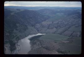
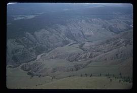
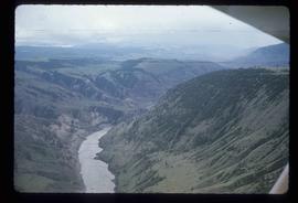
Image depicts a view of the upper Fraser Canyon. The Fraser River is visible on the left side of the image.

Gang Ranch - Fraser River
2012.13.1.52.34 · Item · [1980?]
Parte de J. Kent Sedgwick fonds

Image depicts the Fraser River, and a sign pointing towards Gang Ranch with an unknown individual hugging it, in the Upper Fraser Canyon.

Moran Canyon
2012.13.1.53.19 · Item · Mar. 1975
Parte de J. Kent Sedgwick fonds

Image depicts the Fraser River running through the Moran Canyon near Lillooet, B.C.

Moran Canyon
2012.13.1.53.20 · Item · Mar. 1975
Parte de J. Kent Sedgwick fonds

Image depicts the Fraser River running through the Moran Canyon near Lillooet, B.C.

Moran Canyon
2012.13.1.53.21 · Item · Mar. 1975
Parte de J. Kent Sedgwick fonds

Image depicts the Fraser River running through the Moran Canyon near Lillooet, B.C.

Moran Canyon
2012.13.1.53.22 · Item · Mar. 1975
Parte de J. Kent Sedgwick fonds

Image depicts the Fraser River running through the Moran Canyon near Lillooet, B.C.

Moran Canyon
2012.13.1.53.23 · Item · Mar. 1975
Parte de J. Kent Sedgwick fonds

Image depicts the Fraser River running through the Moran Canyon near Lillooet, B.C.

Moran Canyon
2012.13.1.53.24 · Item · Mar. 1975
Parte de J. Kent Sedgwick fonds

Image depicts the Fraser River running through the Moran Canyon near Lillooet, B.C.

Moran Canyon?
2012.13.1.53.27 · Item · Mar. 1975
Parte de J. Kent Sedgwick fonds

Image depicts what is possibly the Fraser River running through the Moran Canyon near Lillooet, B.C.

Moran Canyon
2012.13.1.53.48 · Item · July 1982
Parte de J. Kent Sedgwick fonds

Image depicts a view of Moran Canyon in the Lillooet area. The Fraser River is visible on the left.

Moran Canyon
2012.13.1.53.50 · Item · July 1982
Parte de J. Kent Sedgwick fonds

Image depicts the Moran Canyon; the Fraser River is visible near the bottom.

Slump or Mining
2012.13.1.65.34 · Item · June 1975
Parte de J. Kent Sedgwick fonds

Image depicts an aerial view of a section of land, likely near the Fraser River, that is possibly either a slump or part of a mining operation. The slide is labelled "slump or mining."

Slump or Mining
2012.13.1.65.35 · Item · June 1975
Parte de J. Kent Sedgwick fonds

Image depicts an aerial view of a section of land, likely near the Fraser River, that is possibly either a slump or part of a mining operation. The slide is labelled "slump or mining."

Landscape - Fraser River
2012.13.1.65.38 · Item · June 1975
Parte de J. Kent Sedgwick fonds

Image depicts an aerial view of the land near the Fraser River. The Fraser River is barely visible on the right side of the image.

Grooving
2012.13.1.65.40 · Item · June 1975
Parte de J. Kent Sedgwick fonds

Image depicts an aerial view of grooves in the land near the Fraser River, possibly caused by glaciers.

Grooving
2012.13.1.65.42 · Item · June 1975
Parte de J. Kent Sedgwick fonds

Image depicts a view of grooves in the land near the Fraser River, possibly caused by glaciers.