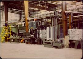
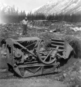
Photograph depicts palletizer machinery, where bags of asbestos fibre were shrink-wrapped and made ready for shipping pallets. Palletizer was located near shipping (believed to be in mill building). Unidentified man visible in machinery on far left.
Photograph depicts Joseph wearing safety gear while standing at testing equipment on raised sampling station. Sign below Joseph reads "DO NOT DISTURB / SAMPLING IN PROGRESS / PROPERTY OF ENVIRONMENTAL CONTROL DEPT. / CASSIAR ASBESTOS LTD." Helen Joseph took air quality tests in the working areas and town (see item 2000.1.1.3.19.135). Power lines, unidentified building, and mountain base visible in background. Photo was taken during winter.
Photograph depicts woman wearing safety gear in second floor of mill building, holding unidentified instruments. Helen Joseph took air quality tests in the working areas and town (see item 2000.1.1.3.19.147).
Photograph depicts mobile home modified for Cassiar winters (steeply sloped roof added). Yellow suburban parked in driveway in left foreground. Forest trees and mountainside visible in background. Sign reading "686" posted on tree in left foreground. Believed to be the home of Gerry Cooper.
Photograph depicts group of men and women on rocky shore, pile of fish in foreground. Photo speculated to have been taken in the Telegraph Creek area, possibly at the Tahltan or Stikine River, B.C.
Mill building in left midground. Conveyor believed to be leading to tailings pile can be seen in foreground. Valley and mountains in background.
Photograph depicts close up view of gravel pit, ruler displayed for scale. Photograph speculated to have been taken at the plant or near the Cassiar airstrip. Stamped annotation on recto of photograph: "JUN. 1987".
Photograph depicts an unidentified man standing to left of large puddle in gravel pit, mountain peaks in background. Photo speculated to have been taken on the plant, or near the Cassiar airstrip, facing south west. Stamped annotation on recto of photograph: "JUN. 1987".
Photograph depicts yellow conveyor belt in foreground over gravel pit, dump truck behind in midground. Mountains visible in background. Photo speculated to have been taken at the plant or near the Cassiar airstrip. Stamped annotation on recto of photograph: "JUN. 1987".
Handwritten caption beside this photo reads: "Work crew eating in open at 10˚ below zero, evicted from Lunchroom, due to damage to, from falling rock." Men are shown sitting in snow. Various metal materials in foreground, snow-covered mountainside in background. It is believed that power lines are also visible in background.
Four construction workers stand to left of blasthole drill number "604" among many empty cardboard boxes. Mountain range can be seen in background.
Conveyor sits on tall steel framework, encased in steel sheeting, and stands to right of snow-covered slope. Propane tank sits on log structure below conveyor. Snowy mountains in background. See also item 2000.1.1.2.373. Handwritten caption below this photo reads: "Project completed - at 52˚ temp."
Photograph depicts the Cassiar valley. Handwritten annotation on verso of photograph: "1958 [1961 crossed through]", on recto: "Cassiar Asbestos Corporation Limited. Cassiar B.C. Townsite in foreground mill and ore storage in left middle ground," "Toronto set". It is believed that this photograph was made into a post card.
Photograph depicts the Cassiar plantsite including the mill, dry rock storage building, tailings pile, and many other buildings. A portion of the townsite can be seen on left.
Photograph depicts large swath of dark waste down mountainside to right of valley. The waste dump is believed to be visible at top of swath on right of image. Bench mining visible on the North and South peak in background. Handwritten annotation on recto of photograph: "Oct. 25 / 65 4:25 PM."
Photograph depicts the Cassiar valley: town in foreground, plant and tailings pile in background. Mountain range visible in distance. Photograph was taken from above, facing east.
Photograph depicts the town of Cassiar, mountain base in background. Mine road visible in top right of image.
Photograph depicts the Cassiar mine above valley, north mountain range in background. Tramline station and crushing plant visible to west of pit. Photograph was taken from the air, portion of plane visible in top left of image.
Photograph depicts the West peak of the Cassiar mine, pit partially visible below. Drill visible in left foreground at highest elevation of mine, north west mountain range in background.
Photograph depicts the Cassiar mine, pit partially visible behind West peak in right centre of image. South west mountain range in background.
Photograph depicts exposed asbestos fibre in talus, shovel in left foreground.
Photograph depicts two men standing on mining bench in mountainside, three boxes and what appears to be a long hose to the left. Third man and tractor plow can be seen in distance at end of bench. Photo caption next to printed copy of image in 1953 Annual Report: "Benches being prepared for mining."
Photograph depicts two unidentified men at high elevation on mountain. Trucks and tanks visible in background, hose (possibly of air track drill) in right foreground. Mountain range in background.
Photograph depicts bench at 6430 elevation. Blasthole drills, shovels, dozers, and dump trucks can be seen on bench in midground. Mine valley in background. Handwritten annotation on verso of photograph: "1961".
Photograph depicts a crawler cable shovel on right, and bulldozer partially visible on left. Rock face of mountainside in background. Handwritten annotation on verso of photograph: "1961", on recto: "Mining 80 D shovel on [?] 64/70 to 6560 saddle on peak."
Photograph depicts dry rock storage building on left, mill in foreground, and tailings piles behind mill in midground. Mountains in background. Handwritten annotation on verso of photograph: "1961".
Photograph depicts 8 men working on top of unknown wooden structure, dog in foreground, mountain base in background. Corresponding note on accompanying photo description page: "1. Erecting 12"x12"s for mill walls. Looking west. Note boulders in foreground ready to be blasted to clear area."
Photograph depicts track loader moving dirt in semi-cleared area, man and mountains in background. Corresponding note on accompanying photo description page: "3. Excavating for ore haul truck dump. Looking west".
Photograph depicts track loader moving dirt, mountains in background. Corresponding note on accompanying photo description page: "4. Excavating for ore haul truck dump with mill in background. Looking southeast."
Photograph depicts flat area mostly covered in snow. Corresponding note on accompanying photo description page: "11. Indicates snow conditions in the cirque. Taken from near first switchback."
Photograph was taken facing down a narrow, snowy trench, mountain base visible at end. Corresponding note on accompanying photo description page: "1. Trench through snow banks at mill site. We had to dig these trenches to facilitate surveying the mill foundations."
Handwritten annotation below photo on page taped to photograph: "PHOTO #2: Looking N across talus slide of asbestos fibre and serpentine fragments." Handwritten annotation on verso of photograph in blue ink describing sections of photograph which have been pointed to or outlined: "Talus of asbestos fibre & serpentine fragments -->" "Photo #1 -->" "Approx upper contact of serpentine -->".
Handwritten annotation below photo on page taped to photograph: "PHOTO #4 Face of cut 4' wide 3' deep. Showing serpentine fragments in loose asbestos fibre. Assumed to overly serpentine high in fibre veinlets. Frost action."
Men can be seen working on site. Crusher building in midground, chutes can be seen crossing the different levels of foundation. Lumber is leaning against excavated dirt wall in foreground, as well as a ladder which reaches up to the base level. Large tank can be seen in top level above building construction. Mountaintop and sky in background.
Photograph depicts two construction workers in far right sitting on edge above of excavation area, and two construction workers behind them standing at a higher level with construction of lumber walls behind them. The boom and stick of the "Northwest" excavator are semi-visible on left.
Switchback road, power lines and tramline towers are believed to be visible in the background valley. Construction of a long structure near the edge of the excavation area can be seen in midground; this is speculated to be the section of the crusher building which housed conveyor "B".
Handwritten annotation on recto of photograph: "POURING RIBS JUNE 29/64." Photograph depicts construction workers on large wooden framework structure extending from base of crusher building. Ladders stand parallel to structure against mountainside. The boom of a crane is visible in foreground. Miscellaneous construction equipment and materials throughout.
Handwritten annotation on recto of photograph: "WEST WALL FOOTING AUG 8/64." Photograph depicts a construction worker standing on rebar in forms built for cement footings. A front end loader and backhoe tractor can be seen on wood platform above footings. Mountainside in background.
Photograph depicts the mine road in valley, view from mountain above. Plant, tailings pile, and town visible in distance. South mountains in background. Handwritten annotation on recto of photograph: "1961-1962".
Photograph depicts view of mine road in valley, from mountain above. Plant, tailings pile, and town visible in distance. South mountains in background. Handwritten annotation on verso of photograph: "1961", on recto: Townsite and Plantsite from mine."
Photograph depicts the North peak of McDame mountain in the earlier stages of strip mining, South peak unmined in background. Quonset and other shops visible in left foreground, unknown building built into mountainside in right foreground.
Photograph depicts the Cassiar mine. North peak featured in left background, South peak in right background, and West peak in right foreground. Area to left of the mining pit and West peak was called the "cirque waste dump." Location of new mine garage can be seen just above the "#7 switchback" road in bottom right foreground.
Photograph depicts the Cassiar mine. North peak featured in left background, South peak in right background, and West peak in right foreground. Area to left of the mining pit and West peak was called the "cirque waste dump." Mountain range visible in distance.
Crushing plant and strip mining area visible in Cassiar mountain range.
Photograph depicts the Cassiar mine. North and South peak featured in background, and West peak in left foreground. Pit is being developed between South peak and West peak. Old mine garage is visible in lower centre of image, and crushing plant in right foreground. Mountain range in distance.
Photograph depicts the Cassiar valley: town in foreground, plant and tailings pile behind. Mine road can be seen from plant to mine valley on left. Mountain range in background.
Photograph depicts the Cassiar valley: town in foreground, plant and tailings pile in background.
Photograph depicts the town of Cassiar behind plant buildings in left foreground. Mountain base in background. Photograph was taken from the air, portion of plane visible in top left of image.
Photograph depicts benches above open pit at Cassiar mine. Drills and haulpaks visible in centre image.
Photograph depicts two pick hammers laid in asbestos fibre. Annotations on note glued to recto of photograph: "ASBESTOS"; "Detail view of asbestos talus. Early test pit near top of showing. Western slope." Areas of image have been labeled "A" and "B". Photo caption under printed copy of image in 1952 Annual Report: "A - Asbestos fibre partially opened by frost action. B - Serpentine rock originally containing the asbestos fibre."