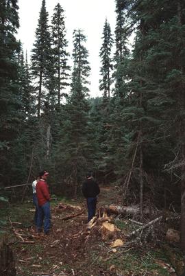
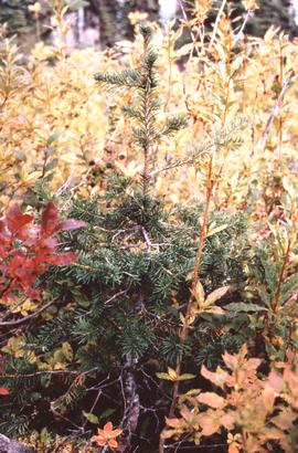
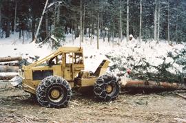
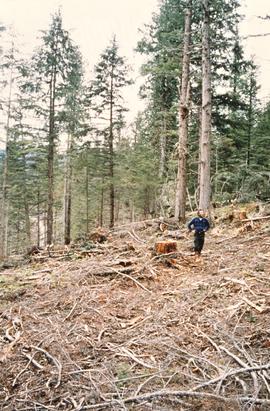
File consists of slides depicting the Aleza Lake Research Forest and area taken by Michael Jull.
Item is a British Columbia Forest Cover Map, serial number 093I001. Includes full format forest cover labels.
File consists of:
- BC Ministry of Forests news release regarding research forest agreements between UNBC and UBC (8 Mar. 1999)
- "A Synopsis of the UBC Research Forests" by Peter Sanders and Ken Day (24 Apr. 1998)
- UBC's Alex Fraser Research Forest list of active research projects (Apr. 1998)
- ALRF's "Proposed Future Management Structure for the Research Forest"
- "Proposal to Assume Management of the Aleza Lake Research Forest" prepared by Ken Day and submitted by UBC and UNBC (22 Dec. 1997)
- Copy of briefing note prepared for David Zirnhelt, Minister of Forests, regarding a research forest for UNBC (Nov. 1998)
File consists of an original Forest Research Note published by the BC Forest Service Prince George Forest Region. This March 1999 note (#PG-16) is an article by Paul Sanborn, Marty Kranabetter, and Chuck Bulmer on "Soil Rehabilitation in the Prince George Forest Region: A review of two decades of research".
File contains an original "Prince George Land and Resource Management Plan" published by the Government of British Columbia.
Mylar map depicts the area encompassed by the Aleza Lake Research Forest.
Annotation on slide: "Horse-logging single-tree selection, Pass Lake SBSvk"
Annotation on slide: "BCMoF"
File consists of summary information for Aleza Lake Research Forest field tours.
Map indicates locations of research trials and permanent plots in the Aleza Lake Research Forest. Map produced by Madrone Consultants.
Item is a British Columbia Forest Cover Map, serial number 093J010. Includes full format forest cover labels.
File consists of:
- "A Summary of Historical Orders-in-Council affecting the Aleza Lake Forest Reserve", Mike Jull, 18 Dec. 1996
- Photocopied memorandum from F.S. McKinnon regarding "Transfer of Aleza Lake to D.F. Prince George", 9 Sept. 1963
- Photocopied 1928 article by P.M. Barr from Forestry Chronicle 4(3) entitled "The Aleza Lake Experiment Station: Its Development and Purpose"
- "A Brief History of the Aleza Lake Experiment Station", [Tim Decie, 1981?]
- Contact information for living relatives of Percy Barr, as of 1990
- Photocopy of 1930 article by Percy Barr entitled "Spruce Reproduction in British Columbia"
- Photocopy of records from BC Archives from a visit by Harry Coates from the file GR 1348 "The Young Mens Forestry Training Program"
- Photocopy of excerpt regarding "Amanita Lake/Diameter Limit Logging"
- Various small-scale maps and charts regarding Aleza Lake
- "Aleza Lake Research Forest Information Session Notes with Mike Jull, Manager of ALRF"
File consists of:
- Draft "Joint Protocol for Co-ordination of Research and Operational Planning Activities at the Aleza Lake Research Forest" between the BC Ministry of Forests, Small Business Forest Enterprise Program, and Northwood Pulp and Timber Ltd. (7 Feb. 1996)
- Application for an Exemption to a Silvicultural Prescription and Logging Plan (19 Dec. 1996)
- Amendment to Special Use Permit #19070, Bowron Floodplain Addition, Aleza Lake Research Forest (1 Aug. 1995)
Map depicts structural stages in the Aleza Lake Research Forest. Shows areas of: pioneer growth, shrub/herb, pole saplings, young forests, mature forests, and old forests. Ecosystem classification and mapping by Oikos Ecological Services Ltd.
File consists of minutes and agenda for the following meetings of the Aleza Lake Research Forest Steering Committee:
- 14 June 1994
- 16 Apr. 1996
- 3 Dec. 1996
Also includes the following accompanying documents: - ALRF Forest Renewal BC Research Extension Proposal Synopses for the Period 1997/98 to 2001/02
- ALRF Planning Project [outline of issues]
Map depicts ecosystems in the Aleza Lake Research Forest. Shows areas of: upland sites without wetland components, upland sites with wetland components, lowland wet forest sites, wetlands, and Bowron floodplain benches. Ecosystem classification and mapping by Oikos Ecological Services Ltd.
Map depicts terrain themes in the Aleza Lake Research Forest. Ecosystem classification and mapping by Oikos Ecological Services Ltd.
Map depicts terrain in the Aleza Lake Research Forest. Ecosystem classification and mapping by Oikos Ecological Services Ltd.
Annotation on slide: "Log skidding on main haul road, Fleet Creek Trial SS054, Jan. 1995"
Annotation on slide: "BC[?] advance regen. releasing in logged cedar block, ICHwk3"
File consists of a document entitled "Proposed Future Management Structure for the Research Forest" accompanying a letter to Paul Sanborn inviting his participation in the Aleza Lake Research Forest Research Working Group.
No annotation on slide.
Mylar map is a plot map of a research plot at the Aleza Lake Research Forest. Provides date the plot was established, the harvest history, the silviculture history, remeasurement history, and information about individual trees.
File consists of a compilation of Experimental Projects in the Prince George Region. This compilation work was done by Stewart Taylor of the Ministry of Forests. Included are Experimental Projects regarding the Aleza Lake Research Forest that were selected from Taylor's larger project, which contained over 400 EP summaries for the Prince George Region.
Mylar map is a plot map of a research plot at the Aleza Lake Research Forest. Provides date the plot was established, the harvest history, the silviculture history, remeasurement history, and information about individual trees.
Annotation on slide: "Lucille Mt. from Mt. Teare, Susan Stevenson, July 1994"
Mylar map is a plot map of a research plot at the Aleza Lake Research Forest. Provides date the plot was established, the harvest history, the silviculture history, remeasurement history, and information about individual trees.
Map depicts historical timber sales areas and permanent sample plots (PSPs) at the Aleza Lake Research Forest. This map may be a guide (or otherwise related) to maps 2006.18.5.43-59.
No annotation on slide.
File contains a trail guide co-published by the BC Forest Service and Northwood Pulp and Timber Ltd. entitled "The North Ridge Eco-Trail Guide: Aleza Lake Research Forest".
No annotation on slide.
Item is a forest cover map for Aleza Lake Research Forest (Special Use Permit 19070). Shows experimental plots and timber sale areas.
No annotation on slide.
File consists of:
- A computer database print-out of photographs held at the Fraser-Fort George Museum that relate to sawmills (as of 1993)
- The Fraser-Fort George Museum's "Northwood Archives Donation Inventory"
File consists of photographic prints and slides depicting partial-cutting and select logging during the EP 1162 Summit Lake research project.
Annotation on slide: "Summit Lake trial, Teapot Mountain, Jull".