File consists of Student's Guide to Prince George c. 1994.
File consists of photographs of UNBC Students. Includes images of Tara Robinson.
File consists of essays and assignments written by Barry McKinnon over the course of his education.
File consists of photographs of UNBC Student Society.
File consists of photographs of UNBC Student Services Street.
File consists of essays and papers written by students.
Videotape contains footage of: 16-Dec-00 - Student for a Day participants - students; Matheson, Ryan
File consists of photographs of the Student Awards Night in 1999.
File consists of photographs of the Student Awards Night in 1998.
File consists of photographs of the Student Awards Night in 1997.
File consists of photographs of the 1997 Student Awards.
File contains handwritten messages, photocopied invitations to a field tour, and related correspondence.
Photograph depicts Stuart Wilson and Nina Norgan.
File includes:
- Memorandum to Stuart S. Holland, 14 Nov. 1941
- Newspaper clipping re: Boulder Creek, ca. Jan. 1939
- Correspondence from Barrington Transportation Company to Stuart Holland, 1 May 1939
- Notes regarding amounts of gold and silver on Wheaton Creek (Boulder Creek)
Collection consists of textual records related to Stuart S. Holland, Associate Engineer, Department of Mines.
Holland, Stuart S.File contains correspondence to Brian Fawcett from Stuart Ross. Includes a letter to Brian Fawcett from Stuart Ross, a friend from Swift-Current. Letter dated April 3, 1989.
The photograph depicts a newspaper map of the business center in Stuart River, South of the Nechako River. Annotation on slide states, "Stuart R. townsite plan"
Northen British Columbia
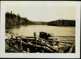
Photograph depicts a small car and passengers on log ferry in foreground and one man on dock. Stuart River and forested banks in background. Handwritten photo caption below photograph reads: "Stuart River Ferry."
The map is taken from the supplement of the Omineca Express/Bugle Caledonia Courier newspaper. The area map depicts highways, secondary roads, lakes, and gravel roads near Fort St. James, Stuart Lake, Fraser Lake, Fort Fraser, and Vanderhoof.
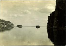
Typed annotation on recto: "Stuart Lake - British Columbia." The hills on left, cliff on right, and two small islands on horizon are reflected in the lake.
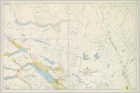
Colour-coded topographic map depicting lands surveyed as alienated, available for purchase or lease under Land Act, or reserved. Depicts land district boundaries, land recording divisions, provincial forest boundaries, HBC posts, triangulation stations, telephone lines, communities, bodies of water, and transport routes.
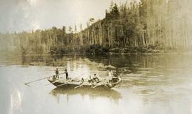
Photograph depicts ten men aboard a scow on a river or lake. The scow is equipped with long poles and may be propelled by steam.
Collection consists of one photograph album containing 28 photographs featuring images of landscapes and water views; fishing scenes; structures; automobiles; persons; Hudson's Bay Company posts; First Nations and wildlife in and about the Stuart Lake area.
This file consists of photocopy reproductions of research material relating to the Missionary Oblates of Mary Immaculate (OMI) in Northern British Columbia, the Stuart Lake Mission, and the Our Lady of Good Hope Church in Fort St. James. Includes:
- Informational email from William O'Hara about the Our Lady of Good Hope Church in Fort St. James, 2014
- Reproduction of article by Bill O'Hara, "Our Lady of Good Hope Church first used at Christmas, 1878" from the Caledonia Courier, 17 Dec 1997
- Reproduction of "Missions de la congrégation des missionnaires oblats de Marie Immaculée - Dix-huitieme Année - No. 69. - Mars 1880" [French], a report that includes mention of "les Babines", "les Sékénés" [Sekani], "les Hotsoten" [Wet'suwet'en], Stuart Lake, Fort George, McLeod Lake, Babine Lake, among others
Northen British Columbia
Series consists of plans, articles, and clippings regarding structures built by railways (with the exception of bridges and stations) in British Columbia. Includes information about engine houses, roundhouses, turntables, water delivery structures, fuelling facilities, freight houses, ice storage shed, tunnels, and other railway structures.
Photograph depicts the Cassiar mine after extensive strip mining. It is believed that the North and South peak stand in background, and the West peak in foreground. Handwritten annotation on recto of photograph: "1971".
