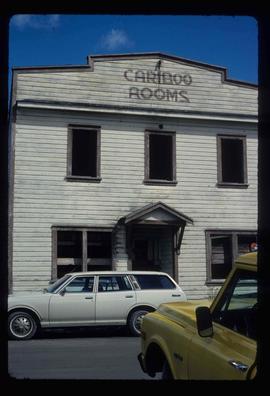
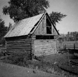
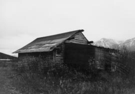
Image depicts the Cariboo Lake, with the roof of an old log cabin visible.
Image depicts a Cariboo Ranch style house at College Heights in Prince George, B.C.
Image depicts the Cariboo Road passing through the Cottonwood House Historic Site.
Image depicts an old, boarded up building labelled as "Cariboo Rooms" in Wells, B.C.
Image depicts the abandoned Cariboo Rooms, and a liquor store in Wells, B.C.
Photograph depicts large crowd gathered in front of three story building.
Printed annotation on recto of photograph: "CARIBOO STAGE AT SOUTH FT. GEORGE B.C. OCT 19 -1911".
Photograph depicts two, four-horse stagecoaches laden with passengers parked outside the Hotel Northern in South Fort George. A group comprised of primarily men watch the stagecoaches from the veranda of the hotel. Handwritten annotation in bottom right corner of photograph reads: "Cariboo Stage at South Ft. George, BC. Oct 19-1911."
Photograph depicts the Carmi Depot located at mile 46.6 on the CPR line in the Carmi Subdivision. This is the only surviving building at the depot. The layout here consisted of 4 passing/storage tracks and 1 short siding. The view is looking north and upgrade.
Image depicts a red carriage labelled in yellow "B.C. Express Co. No. 20." It is possibly located in Kamloops, B.C.
Photo depicts a street perspective cars lining Third Avenue, in Prince George, BC, ca. 1950. Annotation recto reads: "3rd Ave Prince George BC Photo J. Wrathall." Handwritten annotation in pen on verso of postcard reads: “This is the equivalent of our Granville Street. Both theatres are located here as well as Hudson Bay Co., banks, library & stores.”
Elevated view of Third Avenue in Prince Rupert. Several cars and delivery trucks are visible driving along the road. Printed annotation on recto reads: "3rd Ave Prince Rupert BC Photo by Wrathalls."
Street view photograph looking down Carson Avenue at the Front St. intersection in Quesnel, BC. Several identified businesses line the gravel avenue on the right; however Cowan's Hardware store is visible at the intersection on the left. Printed annotation on recto reads: "Carson Ave., Quesnel, B.C. 1930 Looking East."
The item depicts plans for the interior basement, main floor, second floor and the roof of the Carter House at 1850 10th Avenue, Prince George. Original plans drafted in April 1979 and approved by the city and stamped on 1 June 1979. Annotations include notations regarding scale and other measurements.
The item depicts plans for the exterior, longitudinal and transverse sections of the Carter house at 1850 10th Avenue, Prince George.
Image depicts the Carter Industrial Area in Prince George, B.C.
Carvings sit among bushes in front of what appears to be a totem pole.
Handwritten annotation on verso reads: "Eagle & whale Monument Tanu".
Image depicts several unidentified individuals inside a building, one of which is carving a totem pole. The location is uncertain.
Photographs depict aerial views of the Cassiar townsite, plantsite, tailings pile, mine road, bench and pit mine, mine buildings (tramline loading station, crusher, shop, and garage), and surrounding mountain range. Here "aerial" refers to photos depicting a large area and taken from the air or from a high point of elevation.
These blueprints show the proposed layouts and profiles of the tramway to be constructed in Cassiar. Detailed plans for the bucket design as well as the transfer station and operations of the monocable are included.
This blueprint shows the side profile of the proposed tramway to be built in Cassiar. It includes scale drawings of the crusher building, power house and support structures. The degree of tilt of the support structures are marked down where applicable. The side profile is divided into five sections due to the scaled height in elevation and the lack of drawing space. Annotation written along the leading edge of the blueprint reads "Proposed Tramway Riblet".
This file contains images of a land dispute around Cassiar. The photographs depict a cabin on a lot, a destroyed cabin, and outhouses. The accompanied documents in the original file refer to the subjects of "Claims, Leases, and Land lots," and it is implied that there were issues of squatters, illegal occupation, and mineral claims.
Blueprint of the Cassiar Recreational Centre depicting various details regarding aspects of the building. Perspectives included within the blueprint are top-down as well as cross-sections. There are notes by the architect towards how certain building aspects and details are to be found and built throughout the blueprint.
Blueprint of the Cassiar Recreational Centre depicting various details regarding aspects of the building. Perspectives included within the blueprint are top-down as well as cross-sections. There are notes by the architect towards how certain building aspects and details are to be found and built throughout the blueprint. There are annotations located throughout the blueprints written in gold pen and pencil regarding certain errors, changes and further clarification on various aspects of the building from the original plans. Numerical annotation at the bottom right hand of plan imposed new numbering system (3002/09/06 to 12 repectively).
This blueprint depicts the outside layout of the recreation centre and includes its north, south, east and west elevations. Details are included regarding the materials to be used for construction.
This blueprint depicts the outside layout of the recreation centre and includes its north, south, east and west elevations. Details are included regarding the materials to be used for construction. Annotations in gold pen and pencil regarding clarification and changes to certain details are included. Numerical annotation at the bottom right hand of plan imposed new numbering system (3002/09/07).
This blueprint depicts the detailed plans for the recreational centre's entrance hall. There are details pertaining to the elevation of entrance doors, the overall plan of the entrance hall, the upper level staiwell as well as handrailing details.
This blueprint depicts the detailed plans for the recreational centre's entrance hall. There are details pertaining to the elevation of entrance doors, the overall plan of the entrance hall, the upper level staiwell as well as handrailing details. Annotations in gold pen and pencil regarding clarification and changes to certain details are included. Numerical annotation at the bottom right hand of plan imposed new numbering system (3002/09/08).
This blueprint depicts the overall framing structure of the recreational centre. Details include a cross section layout of the recreational centre with relevant framing dimensions, the locations and instructions for assembly as well as types of framing materials to be used.
This blueprint depicts the overall framing structure of the recreational centre. Details include a cross section layout of the recreational centre with relevant framing dimensions, the locations and instructions for assembly as well as types of framing materials to be used. Annotations in gold pen and pencil regarding clarification and changes to certain details are included. Numerical annotation at the bottom right hand of plan imposed new numbering system (3002/09/10).
This blueprint depicts the general layout of the recreational centre. Top-down, side and front perspectives are used. The ground floor, second floor, outside walls and stage layouts are shown.
This blueprint depicts the general layout of the recreational centre. Top-down, side and front perspectives are used. The ground floor, second floor, outside walls and stage layouts are shown. Annotations in gold pen and pencil regarding clarification and changes to certain details are included. Numerical annotation at the bottom right hand of plan imposed new numbering system (3002/09/06).
This blueprint depicts a cross-section layout of the recreational centre which includes a 1/4 scale drawing of a wall unit.
This blueprint depicts a cross-section layout of the recreational centre which includes a 1/4 scale drawing of a wall unit. Annotations in gold pen and pencil regarding clarification and changes to certain details are included. Numerical annotation at the bottom right hand of plan imposed new numbering system (3002/09/09).
This blueprint depicts the overall layout of the heating and ventilating units to be used for the first and second floor of the recreational centre. Details include the locations of fans, boilers, ducts and exhausts as well as typical heating connector connections and the plumbing layout.
This blueprint depicts the overall layout of the heating and ventilating units to be used for the first and second floor of the recreational centre. Details include the locations of fans, boilers, ducts and exhausts as well as typical heating connector connections and the plumbing layout. Annotations in gold pen and pencil regarding clarification and changes to certain details are included. Numerical annotation at the bottom right hand of plan imposed new numbering system (3002/09/11).
This blueprint depicts the gymnasium lighting layout. Also shown is an isometric view of the air supply unit piping as well as a ventilating unit automatic control diagram. Included are detailed notes regarding system desriptions, its plan and layout as well as directions for the automatic control of the ventilation unit and heating systems.
This blueprint depicts the gymnasium lighting layout. Also show is an isometric view of the air supply unit piping as well as a ventilating unit automatic control diagram. Included are detailed notes regarding system desriptions, its plan and layout as well as directions for the automatic control of the ventilation unit and heating systems. Annotations in gold pen and pencil regarding clarification and changes to certain details are included. Numerical annotation at the bottom right hand of plan imposed new numbering system (3002/09/12).
Photograph of Cassiar Towniste with pen annotation on front "Deyo August 1979 - 2 October 1992)."
Photograph depicts the Cassiar townsite behind shadow in foreground. Plantsite can be seen including the mill, dry rock storage building, tailings pile, and many other buildings. Mountains in background. Handwritten annotation on recto: "<- 13 1/2" ->". (This photograph was made into a promotional poster.)
Image depicts a Catholic Church in Stewart, B.C.
Image depicts a Catholic church at an unknown location.
Photograph depicts the catholic church at Cobble Hill on Shawnigan Lake.
Image depicts the Catholic Church in Penny, B.C.
Photograph depicts Catholic church, with rectory on its left, and First United Church behind. A wood boardwalk crosses midground, and a man can be seen riding a bicycle near church. Power lines and rough cleared land in foreground, hills and mountains in background. Handwritten annotation on recto of photograph: "Church in Rupert."
Photograph depicts a cattle barn of the Douglas Lake Ranch.
Photograph depicts a cattle shed located 3 miles east of Pavilion Lake, which is 15 miles northeast of Lillooet. It may have been a settler's cabin at one time.
Photograph depicts a cattle shelter/ barn at the head of Nicola Lake, 20 miles east of Merritt, near the Douglas Lake road turnoff.
File contains slides depicting a caving group in various places in West Virgina, USA.
Image depicts a bridge over Cayoosh Creek.