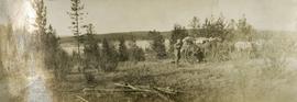
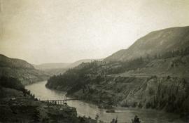
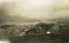
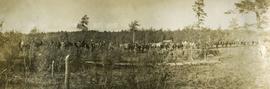
Photograph depicts a long line of 30 or more horses or mules and men. The horses appear to be tethered to a rope, some animals are wearing packs. Several men attend.
Photograph depicts view from behind the ferryman and ship's wheel. Fraser Lake and treed hills in the background.
Photograph depicts a view of the Fraser Lake ferry house from a distance.
Photograph depicts a view of lot 912 near Nechako River.
Photograph depicts the Mamquam River near Squamish.
Photograph depicts a view of Seton Lake and the surrounding area, including the Pacific Great Eastern railway line. The railway grade is visible at left. Also visible is the Seton Lake fish hatchery at the east end of the lake and its employee boarding house, superintendent's cottage, and weir at the head of what was then referred to as "Lake Creek". The road seen in the centre foreground travelled from Lillooet to Seton Lake then to Golden Cache Mine.
Postcard photograph depicting Sternwheeler traveling in river with mountains in the background. Large group of people can be seen on deck, and two unidentified men stand on shore in foreground.
Printed annotation on recto reads: “S.S. Port ‘Simpson Hazelton BC”. Handwritten message on verso is dated “July 31st 1911”.
Photograph depicts what appears to be a sternwheeler in distress. Water in foreground, trees on opposite shore in background.
Handwritten annotation on verso: “S. S. Quesnel on rocks in Fort George Canyon. 1911 – 1915".
Street view photograph of two individuals watching the snow slide down one of the mountains surrounding Stewart, BC. Printed annotation on recto reads: "Snow Slide Stewart B.C. July 7/11."
Side perspective photograph of a train stopped at the Stewart railroad station. Another train can be seen arriving in the distance.
Photograph depicts three men standing and sitting on a porch deck in front of a log house, trees in the background.
Photograph depicts two canvas tents set up near the shore of a small lake or stream. There is a wooden structure on the opposite side of the water. Rough cleared land in the foreground, forested hills and low mountains in the background.
Photograph depicts a view of a lake from above, aspens in the foreground, low rolling hills in the background.
Photograph depicts roughly cleared land in the foreground, canvas tents and a wagon in the midground, lake and hills in the background.
Photograph depicts three or more men near a wagon loaded with supplies. A team of two or more horses are hitched to the wagon. Lake and rolling treed hills in the background.
Photograph depicts a lake. Photograph is framed by a deciduous tree on the left. Forest and rolling hills in the background.
Photograph depicts a man standing on the edge of a trail looking to the treed hills in the distance.
Photograph depicts ten men aboard a scow on a river or lake. The scow is equipped with long poles and may be propelled by steam.
Photograph depicts a view of Squamish, which was named Newport between 1911-1914. This photograph was taken from the Squamish Smoke Bluffs, looking south. Mamquam River blind channel visible in foreground.
Map is entitled "Latest Map of Fort George District" and published 1912. Includes Peace River Recording Land District, Fort George Land Recording District, and Cariboo Land Recording District. Several sections are marked with red pencil.
Photograph depicts a view from the water looking toward Swanson's Bay, BC.
Photograph depicts a long spanned bridge crossing the Fraser River near Chimney Creek, BC.. Album notes state: "views of Chilcotin"
Photograph depicts open range land and treed low hills.
Photograph depicts a muddy road in the middle of open range land with low treed hills in the distance.
Photograph depicts a large corral surrounded by open range with low hills in the distance.
Photograph depicts open range land, a river and sparsely treed hills in the distance.
Photograph depicts a double exposed photograph, a buckboard and open range land with horses and low hills in the distance.
Photograph depicts a man washing clothes using a scrub board and metal wash tub. There is a fire pit in the foreground, tents on either side and forest in the background.
Photograph depicts standing trees that have been burnt, possibly after forest fire. Low hills can be seen in the background.
Photograph depicts of Lowe Inlet BC from the water looking toward the mountains.
Photograph depicts a view from the water looking toward buildings on the shore and mountains in the distance.
Photograph depicts the waterfall Brandywine Falls.
Photograph depicts a snow covered cemetery with gravestones, tombstones, and monuments.
Photograph depicts a dock and building near the water. A few buildings are being constructed on some newly cleared land nearby.
Photograph depicts a view from the water of Lowe Inlet.
Photograph depicts a long spanned bridge crossing the Fraser River near Chimney Creek, BC.. Album notes state: "views of Chilcotin"
Photograph depicts a view of the Fraser River bordered by sparsely treed hills. Album notes: "views of Chilcotin".
Photograph depicts open range land and treed low hills.
Photograph depicts a close up view of the range grass.
Photograph depicts a rough table under a canvas tarp. There are various cooking utensils on the table and hanging from the tarp support. A man stands behind the table.
Photograph depicts a stage coach with a team of horses harnessed to it. The stagecoach driver sits on the front bench, sitting beside the coach driver are; a woman with a small child and a man. There is a building in the background.
Photograph depicts thickly forested area.
Photograph depicts one or two person's bending over a washtub. There are tall trees behind and a canvas tent to the right.
Photograph depicts passengers on the deck of the S.S. Prince Rupert. A man stands in the foreground while two women read books on deck.
Photograph depicts view of Prince Rupert harbor from a deck.
Photograph depicts a view looking down on the buildings of the city of Prince Rupert BC and beyond to the harbor and mountains in the distance.
Item is a photocopied map depicting the Cariboo district of British Columbia, in the vicinity of Summit Lake and the Salmon River.
Photograph depicts the Upper Canyon, Cheakamus River. The photograph was likely taken from the railway grade at approximately "20 mile", looking north.
Winter scene with buildings, street, and utility poles. Hill in background.
Handwritten annotation on verso: “South Ft. George 1912”.