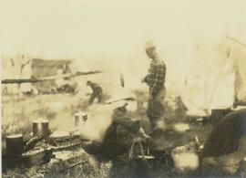
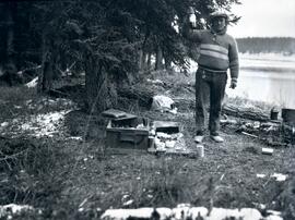
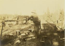
Photograph depicts an unidentified man cooking food in several pots over a fire at a camp site. In the background several tents are visible in front of a forested environment.
Photograph depicts an unidentified man cooking food in pots over a fire while another man looks on. In the background several tents and a man are visible.
Man stands by doorway of large house. Sidewalk, front lawn, and palm trees in foreground. Photograph speculated to have been taken in Los Angeles, California.
Photograph depicts a man bathing himself while standing in a small metal tub. Photograph description in album notes this as "His 'Semi Annual'" [bath]. On the left is a log structure, presumably a cache building. A large clearing surrounds the building and bathing man. There is a forest and bluff in the background. Possibly located near Giscome Portage.
Photograph depicts a man on horseback standing alone on a mountain slope. In the background an alpine lake is visible at the base of a mountain.
Image depicts a man, with what is possibly the Robson Glacier visible in the background.
Photograph depicts a view of main street Grand Forks BC.
Photograph depicts a view of main street Grand Forks, BC. There are power poles in the center of the photograph, buildings line the street
Photograph depicts a view of main street Grand Forks, BC.
Photograph depicts a billboard size sign on the side of a building in Grand Forks BC.
Photograph depicts a view of main street Grand Forks, BC.
Photograph depicts a group of men standing near a building with the sign, "James Reid Ltd. General Merchants". There are a few fences and buildings in the background.
File consists of a note and reproduction relating to Mackenzie, BC.
Photograph depicts Mac McGarvey (right) and Frank Dewing (left) sitting in a boat on the Peace River. Mac McGarvey is steering the boat while Frank Dewing is pumping water from the boat. In the background a low mountain range is visible.
Photograph depicts Mac McGarvey (left) and Frank Dewing (right) getting the boat "Starvation" ready on a rocky shoreline in preparation for travel on the Peace River.
Photograph depicts Mac McGarvey (right) and Frank Dewing (left) seated in a boat on the Peace River. Mac McGarvey is steering the boat while Frank Dewing is pumping water from the boat.
File consists of notes and reproductions relating to Luther Collins Gunn and L.C. Gunn Park. Luther Colins Gunn was a survey engineer who had done work for the Grand Trunk Pacific Railway and the Pacific Great Eastern Railway when he arrived in Prince George. The L.C. Gunn trail follows the same route used by Gunn when surveying the rail routes in the Prince George area. Includes: "Gunn Point" typescript document by Ted Williams for the Heritage Advisory Committee (1985); "A Proposal - The L.C. Gunn Viewpoint" typescript letter to Mr. Mac Norris, president of the B.C.R. Company from Ted Williams and the Heritage Advisory Committee (27 Jan. 1987); and "Item of business, proposed use of District Lot # 486" typescript letter from the Heritage Advisory Committee to Beverley Pitman, Planning Assistant (31 May 1979). Also includes photographs depicting the Moffat farm (2005).
Photograph depicts a sleeping dog and a man holding up a bottle standing between a small campfire and box filled with dishes. In the background of the image there is a forested landscape and a river to the right of the man.
Photograph depicts of Lowe Inlet BC from the water looking toward the mountains.
Photograph depicts a view from the water of Lowe Inlet.
Photograph depicts a stream of water, a steep canyon wall in the background.
Photograph depicts a view of sparsely forested rolling hills with low mountains in the background.
Photograph depicts a view of sparsely forested hillsides with a creek in the center of the photo, low mountains in the background.
Photograph depicts river and high river bank in the distance.
Photograph depicts rolling hills with dry vegetation and river in the background.
Photograph depicts tree tops and sky.
Photograph depicts a view past tree tops to a snow capped mountain range.
Photograph depicts looking beyond a treed mountain ridge to snow capped mountains in the distance.
Photograph depicts a view of a forested mountain valley, looking toward a peak.
Photograph depicts a man walking toward the photographer on a railroad track. Along side the track is newly cleared land with some building and tents. Forested hills and mountains in the background.
Photograph depicts looking down a railroad track on the left, a few scattered shanties in the right foreground, freshly cleared land, forest and a mountain range in the distance.
Photograph depicts newly cleared land with three or more buildings. Forest and mountains in the background.
Photograph depicts a view of a log jam on the Kettle River from Billings siding.
Photograph depicts a man loading up pack horse with two other laden pack horses visible in the periphery of the image.
Photograph depicts five men loading packed bags into a long boat belonging to Mac McGarvey. The boat is resting near the shore of an inlet at Rolla Landing.
Photograph depicts three or more men near a wagon loaded with supplies. A team of two or more horses are hitched to the wagon. Lake and rolling treed hills in the background.
Photograph depicts a pack horse train heading up a snow-covered path along a mountain trail. The environment around the sloping mountain trail is sparsely covered with trees.
Photograph depicts a train of pack horses carrying loaded packs and walking up a mountain trail.
Photograph depicts a loaded packhorse carrying Prentiss Gray's camera equipment.
Photograph depicts a view from the ocean toward a lighthouse on a rocky ocean shore point. There are a few building near the lighthouse.
The Lieutenant Governor speaks to Her Majesty The Queen while Prince Philip, the Royals’ bodyguard and her Honourary Aide de Camp look on. Vehicles and large building visible in background.
The Lieutenant Governor stands next to bridge and highway at top of image, cliffs and white water rapids visible below.
Handwritten notation affixed to verso reads: “Stikine Canyon Sept 2006”.
Photograph depicts a cluster of wooden buildings including a flagpole and church spire at a Lheidli T'enneh village site. Original photo identified this image as "Indian Village, Fort George".