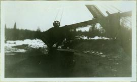
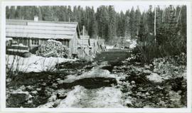
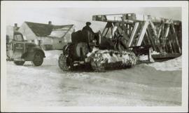
Photograph depicts man believed to be Bob Baxter on bulldozer by large framework structure in snow. House stands in background as well as a truck with "CITY OF PRINCE GEORGE" visible on its passenger door. Handwritten annotation on recto of photograph: "Civic centre 1948."
Bulldozer visible to left of road in distance, mountain in background.
Item is a photograph of a bulldozer removing debris from train tracks on August 27, 1956 location unknown.
Overview of Giscome, BC showing built and natural landscape.
Handwritten annotation in pencil on verso: "Bunkhouse & Dining Room / Giscome BC".
Photograph depicts disused, but perhaps not legally abandoned, track 2 miles south of Keremeos on the old Keremeos branch. The track was broken in several places and fences were also erected across its length.
Photograph depicts a disued or abandoned track 2 miles south of Keremeos. Tracks was broken at one bridge and at least one cover was as well. Fences were erected across it.
Photograph depicts a BN snow plow in Fruitvale.
Photograph depicts boat named "Burnaco."
Image depicts a stretch of road somewhere at Burns Lake, B.C.
Photograph depicts the Burrard Dry Dock Co. Ltd. on the North Shore in Vancouver. There is a freighter in dock #2.
Photograph depicts a self-propelled rail barge.
Photograph depicts the business car "British Columbia" (ex. C.P.R.) at the C.N. station in Vancouver. It is tailing the special to Hope, on its first run since acquisition by the West Coast Railway Association.
Photograph depicts the business car "Van Horne" at the C.P.R. False Creek yard in Vancouver, B.C. It is not numbered.
Photograph depicts a C.P.R. fire car (extender) on the Esquimalt and Nanaimo Railway at Parksville, B.C. on Vancouver Island.
Photograph depicts the boom, stick, and bucket of a "Northwest" cable shovel loading a dump truck in excavation area, snow and forest in background.
Photograph depicts the end view of a cable/hose car.
Photograph depicts a cable/hose car (work car) that was not part of the Kamloops Auxiliary.
Photograph depicts a caboose that was formerly part of KVR and was on its way to Grand Forks. It now only went 3 miles to the Canadian Cellulose pulp mill in Kraft.
Photograph depicts a wooden-sided caboose, CPR #43708, arch bar trucks. It was built in September 1943 and may have been part of a wreck train.
Photograph depicts CPR caboose #400572 at Cranbrook. It is an older style caboose with older style lettering.
Photograph depicts a caboose used as a mobile "Maintenance of Way" office. It was a transfer yard caboose built in Montreal in 1977-8. Made into a series of which all except two had been put to other uses since 1991-2.
File consists of documentary photographs taken by David Davies of miscellaneous cabooses in British Columbia.
Photograph depicts a line of CPR cabooses and work cars at Nelson. The foremost is #437374 and was built in September, 1948.
Postcard depicts a cairn "marking the spot where Canadian Pacific Railway was completed on November 7th, 1885. Twenty-eight miles west of Revelstoke, BC"
Buildings visible on hillside in background, pier in foreground. Photo believed to have been taken at Port Simpson, B.C.
Photograph depicts sternwheeler being towed by smaller vessel, shore in background.
Handwritten photo caption beside image reads: "Caledonia".
Photograph depicts the Cambie St. Bridge in Vancouver, BC, looking east and showing the north fixed span of the bridge.
Photograph depicts the Cambie St. Bridge in Vancouver, BC, showing the west side and view facing south.
Photograph depicts the Cambie St. Bridge in Vancouver, BC, looking east and showing the central swing span.
Photograph depicts the Cambie St. Bridge in Vancouver, BC, looking southeast and showing the southern fixed span on the bridge.
Photograph depicts the Cameron Lake station on the Alberni branch of the Esquimalt and Nanaimo Railway on Vancouver Island. It is no longer used but has been converted to a lodge. The view is looking west.
Photograph depicts four men in campsite. Cooking supplies and miscellaneous items in foreground, forest trees in background. Handwritten annotation on verso and recto of this photograph reads: "Camp at Portage in Grand Canyon".
Photograph depicts a numerous variety of buildings in snowy clearing of forest. A car is parked in foreground on road leading into the camp. Handwritten caption beside this photo reads: "Sumit Lake Camp". It is speculated that this may be the Campbell Construction Co. road camp.
Photograph depicts the camp at Summit Lake, B.C., a numerous variety of buildings in snowy clearing of forest. A car is parked in foreground on road leading into the camp. It is speculated that this may be the Campbell Construction Co. road camp.
Photograph depicting a camp ground, with fifth wheel's and vehicles parked in front of a lake, presumably taken at Quesnelle Forks campground.
Photograph depicts three men and dog in tent campsite. Cooking supplies and miscellaneous items in throughout, forest trees in background. Handwritten annotation on verso and recto of this photograph reads: "Camp on Upper end of Grand Canyon".
Photograph taken at the Campbell Creek Industrial Park in Kamloops. Depicts the CNR end of head shunt. The connection with the Okanagan Branch is found in the middle distance.
Photograph taken at the Campbell Creek Industrial Park in Kamloops. Visible CNR track was to be inactive by August 1998.
Image depicts numerous campers and other vehicles in Tumbler Ridge, B.C.
Photograph depicting a campground with log cabins and an open field surrounded by trees, presumably in Quesnelle Forks.
Photograph depicting a campground and open field surrounded by trees, presumably in Quesnelle Forks.
Photograph depicting a campground with log cabins and an open field surrounded by trees, presumably in Quesnelle Forks.
Photograph depicting a river with rocks lining the shore and trees in the background, presumably at the campground in Quesnelle forks.
Image depicts a man at a campsite somewhere near Murray Ridge.
Photograph depicts five long buildings in forest clearing, lining left of a road down the center of the image. Wood piles are stacked against buildings. Men can be seen in distance near a white tent.
Map depicts Canadian railways in operation at 2011.
Photograph depicts the Canadian Coast Guard rescue launch "Moorhen" or "Mallard."
Photograph depicts a 39 foot Canadian Coast Guard search and rescue hoverscraft in the Strait of Georgia near Vancouver. This vessel has gas turbine engines, a top speed of over 50 knots, and is specially equipped for inshore search and rescue operations.
Photograph depicts the Canadian Coast Guard ship "Camsell" in Upper Harbour, Victoria.