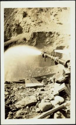
Showing 6040 results

Archival description
2849 results with digital objects Show results with digital objects
5810 Bench Plan for 1972
2000.1.2.6.3 · Item · November 30, 1972
Part of Cassiar Asbestos Corporation Ltd. fonds

This map depicts the generalized pit layout and estimated waste extraction areas for 5810 bench. Annotated details include numerical bench markers, extraction dates and approximate ore extraction amounts. The hand drawn plan consists of solid and dotted lines drawn with green, orange and lead pencil.

2000.1.2.6.6 · Item · October 1972
Part of Cassiar Asbestos Corporation Ltd. fonds

This map depicts the pit layout and estimated waste extraction areas for 6320 bench for the end of September to October. Extraction dates are included within certain portions of the plan. Annotated details include numerical bench markers, extraction dates, and approximate waste tonnage calculation for October. The hand drawn plan consists of solid and broken lines drawn with red, orange and lead pencils as well as black ink.

2009.5.2.44 · Item · 25 July 1939
Part of Taylor-Baxter Family Photograph Collection

Photograph depicts a large structure in center of mining area in riverbed, equipment and supplies scattered throughout. Buildings and forest in background. Handwritten annotation on verso of photograph: "Spruce Creek, Lower Shovel Workings 6/25/39.", on recto: "Atlin".

2009.5.2.51 · Item · [ca. 1910?]
Part of Taylor-Baxter Family Photograph Collection

Photograph depicts two log buildings in fenced area on lake shore, forest trees in background. A man can be seen standing near docking area and small boat pier extending into water in foreground. Handwritten annotation on recto of photograph: "Fur Farm Red Rock Lake". This location is believed to at mile 27, north of Summit Lake.

The Bourchier Album
2009.5.3 · File · [ca. 1895 - 1950]
Part of Taylor-Baxter Family Photograph Collection

This photograph album consists of photographs of remote police barracks at Mile 47 and Mile 29; early settlements and/or mercantile stores at Tete Jaune Cache, McBride, Sand Creek, Fort George and South Fort George; Grand Trunk Pacific Railway forestry and railway camps; scows and paddlewheel conveyors on the Fraser River; automobiles; community leisure activities; as well as, images of the Bourchier family. The following South Fort George establishments are identifiable within these photographs: Empress Hotel, Ah Yee General Merchant, German Bakery, Northern Hotel, South Fort George Drug Store & Post Office, St. Michael’s Church, Prince George Hotel, Ford Monarch dealership, Astoria Hotel, and King George V Elementary School. Identified geographic locations featured in these photographs include: Tete Jaune, Upper Fraser, Mile 47, Mile 29, Fraser River, Mt. Robson, McBride, Sand Creek, Glacier Mountain, Moose River, Giscome Portage, Pott Falls, Red Deer River, Grand Canyon, Summit Lake, Canoe Pass, Connaught Hill, Nechako Bridge, and Island Cache.

Bourchier, Alan K.
2009.5.3.38 · Item · [ca. 1913]
Part of Taylor-Baxter Family Photograph Collection

Photograph depicts three men standing with oars in small boat, forest slash at their feet. More slash lies in foreground behind bushes and plants on swampy shore. Trees in background. These men are believed to be members of the Bourchier forestry crew.

2009.5.3.157 · Item · [ca. 1910]
Part of Taylor-Baxter Family Photograph Collection

Photograph depicts men on river boat and small canoe floating just off shore. Men sit and stand on shore among square bales and large cut lumber. Forest in background. Handwritten annotations on recto of photograph: "Fort Fraser wooding up at Giscome Portage", "Chilco at Giscome Portage".

Environment
2009.6.13.13 · Subseries · 1974-1979
Part of The Honourable Iona Campagnolo fonds

Subseries consists of correspondence relating to the Department of Environment (Environment Canada), the Department of Fisheries and Oceans (Fisheries and Oceans Canada), and environmental issues. Includes correspondence regarding Ministry of Environment programs and procedures; the Canadian forestry industry; forestry licenses; pollution and legislation controls for industry pollution; oil spills; polychlorinated biphenyl pollution; floods and flood control mechanisms; dams and stream diversions; trapping legislation; and wildlife conservation. Also includes correspondence regarding inquiries intro fisheries management legislation and policies; fisheries licensing; salmon fisheries issues; inquiries and statements of opinion about the yearly seal hunt; whale conservation; the economic zone off-shore fishing limits; small craft harbours; sport fishing; and the roe herring fishery. Contains speeches given by the Minister of Environment or given on his behalf and news releases from Fisheries and Oceans Canada.

6380 Bench Plan for 1972
2000.1.2.6.10 · Item · October 4, 1972
Part of Cassiar Asbestos Corporation Ltd. fonds

This map depicts the pit layout and estimated waste extraction areas for 6380 bench. Extraction dates accompanied by its total tonnages are located within each planned area. Certain extraction dates are labeled with bench numbers. Annotated details include extraction dates, approximate total tonnages per area as well as extraction dates, total planned and broken tonnages, total tonnages from December 31, 1970 from a survey done in September 1, numerical bench markers as well as a rough colored legend depicting extraction month by color. The hand drawn plan consists of solid lines drawn with green, yellow, red and lead pencils.

6320 Bench Plan for 1972
2000.1.2.6.12 · Item · October 4, 1972
Part of Cassiar Asbestos Corporation Ltd. fonds

This map depicts the pit layout and estimated waste extraction areas for 6320 bench. Extraction dates accompanied by its total tonnages are located within each planned area. Certain extraction dates are labeled with bench numbers. Annotated details include extraction dates, approximate total tonnages per area accompanied by extraction dates, total planned tonnages, total tonnages from December 31, 1971 as well as a rough colored legend depicting extraction month by color. The hand drawn plan consists of solid lines drawn with green, red, orange and lead pencils.

The Asbestos Sheet Dec. 1961
2000.1.3.1.081 · Item · Dec. 1961
Part of Cassiar Asbestos Corporation Ltd. fonds

"The Asbestos Sheet" is a newspaper that documents the community and work life of the residents of Cassiar BC. Content includes text and photographs, as well as jokes, comics, and games. (Note: this issue appears to be an extra addition to the year's circulation; the exact date of publication is unknown)