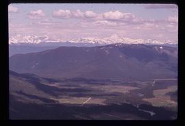
Image depicts a field of hay somewhere in Beaver Valley.
Image depicts a trailer park in Mackenzie, B.C.
Image depicts several apartment buildings and the sign for a Gulf Gas Station in Mackenzie, B.C.
Image depicts a man and his family filling up their truck with gas at Manson Creek, B.C.
Image depicts the Germansen Landing Trading Post.
Image depicts a view of McGregor Valley from an uncertain location.
Image depicts a bridge over the McGregor River.
Image depicts a farm in Giscome, B.C.
Image depicts a view of McGregor Valley.
Image depicts a bridge over the McGregor River.
File contains slides depicting Pine Pass and Murray Ridge, B.C.
Image depicts a man leaning on a rock somewhere on Murray Ridge.
Image depicts a man sliding down the remaining snow on Murray Ridge.
Image depicts a section of river located somewhere near Barriere, B.C.
Image depicts a mountain range located somewhere along the Skeena River.
Image depicts Highway 16 en route to Prince Rupert, B.C.
Image depicts the Skeena River.
Image depicts a view of Terrace, B.C.
Image depicts a rail road bridge located somewhere near Terrace, B.C.
Image depicts a view of what is possibly a shipping yard in Prince Rupert, B.C. The slide is labelled "superport."
Image depicts the ferry to Alaska in the port of Prince Rupert, B.C.
Image depicts numerous boats docked by a buildings identified as the "Prince Rupert Fishermen's Co-operative Association."
Image depicts a grain elevator in Prince Rupert, B.C.
Image depicts the Hecate Strait near Prince Rupert, B.C.
Image depicts numerous docked boats somewhere in Prince Rupert, B.C.
Image depicts a pulp mill in Port Edward, B.C.
Image depicts an old building on the main street of Prince Rupert, B.C. Only half of the business name is visible: "Skeena Color [sic]."
Image depicts the Bank of Nova Scotia located on "Besner Block" in Prince Rupert, B.C.
Image depicts a large vessel docked at a grain elevator and two smaller boats at a dock in the foreground somewhere in Prince Rupert, B.C.
Image depicts numerous boats docked in Prince Rupert, B.C.
Image depicts the coastline of Haida Gwaii, B.C.
Image depicts a downward view of a small section of the shore of Haida Gwaii.
Image depicts the coastline of Haida Gwaii, B.C.
Image depicts an individual ducking under a tree branch somewhere in Haida Gwaii, B.C.
Image depicts numerous trees in the coastal forest of Haida Gwaii, B.C.
Image depicts Haida Gwaii.
Image depicts a ferry docked at Haida Gwaii, B.C.
Image depicts an individual, possibly Sue Sedgwick, standing next to a very thick and tall tree somewhere on Haida Gwaii.
Image depicts an individual walking on a path through a forest somewhere on Haida Gwaii.
Image depicts Kent Sedgwick standing on the other side of a log bridge in a forest somewhere on Haida Gwaii.
Image depicts a fence and power lines near the shore on Haida Gwaii. It is possibly a small community such as Masset.
Image depicts a view of the coast of Haida Gwaii.
Image depicts a lake with lily pads somewhere on Haida Gwaii.
Image depicts an individual sitting on a dock on a lake somewhere on Haida Gwaii.
Image depicts a vehicled parked on the side of the road, with a view of the coast of Haida Gwaii in the background.
Image depicts a view of Tumuch Lake Valley, south-east of Raven Peak.
Image depicts the start of the Raven trail, with the view angled towards Raven Peak in the distance.
Image depicts several individuals walking the Raven trail.
Image depicts a woman standing in a field, with a sign in a tree behind her pointing the way towards the Raven Cabin.
Image depicts a small grey building, possibly Raven Cabin, sitting at the foot of a ridge.