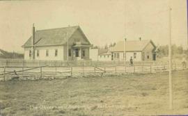
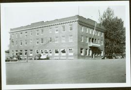
Showing 473 results

Archival description
450 results with digital objects Show results with digital objects
2011.3.2.06 · Item · [ca. 1910]
Part of North Coast & Central BC Postcard Collection

Photo of buildings behind street, fenced on either side. Man and horse can be seen on street. Printed annotation on verso reads: “The Government buildings Fort George B. C.” Handwritten annotation on recto reads: “This is the place I receive my patent from next June.”

2011.3.3.3 · Item · [ca. 1910]
Part of North Coast & Central BC Postcard Collection

Printed captions below images on recto read: “Souvenir of Prince Rupert BC; Prince Rupert June 1st, 1909; Prince Rupert Sept 1st, 1913; Public School; Water Front; City Hall; Haye Cove; Margaeto Fleet; Harbour Scene; SS Prince Marquitta at Prince Georg; Sunrise Prince Rupert Harbour; General Hospital; Gold Storage Place; Prince Rupert from Summit”.

Handshake
2012.13.1.133.09 · Item · 1985
Part of J. Kent Sedgwick fonds

Image depicts a man and woman shaking hands in a building at an uncertain location, possibly in Cottonwood Park. The man standing behind the two is possibly Elmer Mercier, a former mayor of Prince George, B.C.

Woman with a Paper
2012.13.1.133.10 · Item · 1985
Part of J. Kent Sedgwick fonds

Image depicts a woman holding a sheet of paper in a room with numerous other unidentified individuals. The man standing behind her is possibly Elmer Mercier, a former Mayor of Prince George, B.C.

Map Board?
2012.13.1.133.11 · Item · 1985
Part of J. Kent Sedgwick fonds

Image depicts a man holding up a board which appears to have maps of the Cottonwood Park on it.

Cottonwood Park Opening
2012.13.1.133.12 · Item · 1985
Part of J. Kent Sedgwick fonds

Image depicts Elmer Mercier, a former mayor of Prince George, B.C., cutting the ribbon to open Cottonwood Park's Heritage Trail.

City Hall
2012.13.1.3.165 · Item · May 2001
Part of J. Kent Sedgwick fonds

Image depicts Prince George City Hall. Map coordinates 53°54'46.3"N 122°44'41.9"W

George Street
2012.13.1.7.220 · Item · May 2001
Part of J. Kent Sedgwick fonds

Image depicts a view of George Street with the Prince George City Hall at the corner of George Street and 7th Avenue.

"The Canada Chart"
2012.13.2.01.07.1 · Item · 1983
Part of J. Kent Sedgwick fonds

The Canada Chart depicts Canadian federal and provincial and government information and graphics.

2012.13.2.02 · Subseries · 1941-2011
Part of J. Kent Sedgwick fonds

Subseries includes research material created and collected by Kent Sedgwick relating to land survey, development, and settlement in Prince George and British Columbia. Land surveys were conducted in British Columbia by surveyors George Dawson, the North Coast Land Company, Alfred R.C. Selwyn, and the Geological Survey of Canada during the late 19th and early 20th centuries. James C. Anderson and engineer J. Gill conducted topographical surveys for the Grand Trunk Pacific Railway on Fort George and the Indian Reserve. Surveyors and land plot companies developed the land for sale to promote settlement in the area. Also includes materials regarding the continued development of the City of Prince George throughout the 20th century. The files primarily consist of newspaper clippings, research notes, and photocopied documents.

2012.13.2.06.05 · File · 1986-2009
Part of J. Kent Sedgwick fonds

File consists of notes, clippings, and reproductions relating to the history of businesses within Prince George. Includes the following clipped articles from the Prince George Citizen newspaper: "The History of Pastry Chef Bakery" (Nov. 2010); "Sole man" (June 2009); "Celebrating 95 years in Prince George" (Feb. 2006); and "Overwaitea Remembers Famous Green Teapot" (Feb. 1986). Also includes a CKPG Radio special anniversary issue of "Golden waves" and photographs depicting the demolition of Parkwood Mall (8 Apr. 1997).

2012.13.3.1.18 · File · 1989-2011
Part of J. Kent Sedgwick fonds

File consists of notes, clippings, and reproductions relating to federal government buildings in Prince George. Includes: "Fw: Info - Prince George Former Post Office - 1294 3rd Avenue" printed email from Trelle Morrow to Kent Sedgwick (27 May 2011); "City of Prince George" typescript letter to Noel O'Beirne from Kent Sedgwick (13 Nov. 1991); "Possible users for federal government building 3rd Avenue/Quebec Street" typescript letter to Alderman Becott from Kent Sedgwick (10 Oct. 1989); "City of Prince George" typescript letter to Dr. Colin Campbell, Director of Heritage Conservation Branch from Kent Sedgwick (5 May 1989); "RE: Municipal Heritage Designation of Federal Government Building" typed letter from Ian Whitbread to Kent Sedgwick (28 Mar. 1991); "Bylaw No. 5538" typescript document from the City of Prince George (3 Apr. 1991); "Public Notice 'Heritage Designation Bylaw No. 5538, 1990'" typescript document from B.C. Williams, City Clerk (1990); "Intersect" typed letter to Kent Sedgwick from Kathy Antonyk (14 Mar. 1994); and "Heritage Conservation in your community..". pamphlet from the Heritage Advisory Committee (1994). Also includes a photograph depicting the old Post Office in Prince George (1990).