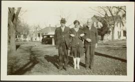
Young unidentified woman stands with linked arms between to unknown men in grass area. Road, car, large trees, and homes stand in background.
Young boy stands among bushes in snow, totel pole in background.
Handwritten annotation on verso reads: “WE Collison Totem on QCIsl."
Seven year old Virginia stands beside older sister Violet who is seated on chair in front of house at South Fort George. Two small children can be seen standing in porch. Handwritten annotation on recto of photograph: "Virginia and I."
The two girls stand in front of a house at South Fort George, B.C. Young boy believed to be Arthur Taylor can be seen in background. Handwritten annotation on recto of photograph: "After the Ball was over, Violet and Virginia lay [...] August 22, [192...] South fort George B.C." (Annotation is cut off).
Fourteen year old Violet stands beside younger sister Lucy who is seated on chair in front of house at South Fort George. Handwritten annotation on recto of photograph: "Lucy and I."
Seven year old Virginia stands beside older sister Violet who is seated on chair in front of house at South Fort George. Two small children can be seen standing in porch. Handwritten annotation on recto of photograph: "Violet & Virginia - 1921 -" (date believed to be incorrect).
Photograph depicts Mary standing in dirt area at corner of log building. Image has been cropped to an oval shape. Handwritten annotation on recto of photograph reads: "Mary Houghtaling to Mrs Boucher [sic] Born [July 17] 1910 Prairie [Creek] 1911".
Photograph depicts group of boys standing in front of door and steps of building, two pedal bikes parked on left.
Virginia stands beside a young man speculated to be her older brother Art. Porch of house in South Fort George in background.
Image depicts the Yellowhead Bridge across the Fraser River. Map coordinates 53°54'45.2"N 122°43'27.9"W
Image depicts the Fraser River and the Yellowhead and Grand Trunk Railway Bridges from LC Gunn Park. Map coordinates 53°54'30.7"N 122°43'27.0"W
Image depicts a building in Wells, B.C. It possesses the letters "W.V.F.B." on it.
Photograph depicts the Wrinch Memorial Hospital. It held 54 beds and was founded by Dr. Winch for the benefit of the local First Nations population.
File consists of clippings, notes, and reproductions relating to World War 2 in Prince George. Includes various clipped articles from the Prince George Citizen newspaper; "Wartime bldgs" handwritten notes by Kent Sedgwick (2005); and a John Bogle UNBC history course paper (1999). Also includes photographs taken in 2005 of various buildings and houses in Prince George.
The item is a black and white photograph depicting a boarded up workshop, garage and covered farm building. Picture is taken from the road.
The item is a black and white photograph depicting a boarded up workshop on a farm.
The photograph depicts a white workshop with a red roof at the Prince George airport.
Photograph depicts two unidentified men wearing coveralls, hard hats, and headphones, while working at table in garage. Blasthole drill stands behind them in background.
Photograph depicts two unidentified men in coveralls and hard hats, working in garage. Blasthole drill stands behind them in midground, walls in background.
Photograph depicts large trailer truck parked at what is believed to be the loading station on the Cassiar plant (possibly in mill building).
Photograph depicts Ruston Hornsby diesel engines which turned the generators in the power house on the Cassiar plant. Two unidentified men wearing coveralls can be seen in image.
Plant buildings stand in midground. Conveyor believed to be leading to tailings pile can be seen in foreground. Valley and mountains in background.
Mill building in left midground. Conveyor believed to be leading to tailings pile can be seen in foreground. Valley and mountains in background.
Photograph depicts the old company store located at corner of Connell Driver and Creery Street. Retail store was located under company cafeteria "the Cookery", with butcher shop in back. The Cookery was known for serving good food and providing excellent service.
Photograph depicts two unidentified men standing on Ruston Hornsby diesel engine which turned the generators in the power house on the Cassiar plant.
Photograph depicts unidentified man standing on Ruston Hornsby diesel engine which turned the generators in the power house on the Cassiar plant.
Photograph depicts two large tanks with Cassiar logo on front, labeled "1" and "2". Road in foreground, garage in background. Mountain base also visible in background.
Photograph depicts what appears to be a Euclid ore haulage truck at entrance of building speculated to be the truck dumping station at crusher plant in mine.
Photograph depicts a building with a truck parked in front on the corner of Connell Drive and Creery Street.
Photograph depicts four large buildings behind power lines, believed to be located on Malozemoff Avenue. Trucks in foreground, forest and mountains in background.
Photograph depicts large building behind power lines, car in right foreground.
Handwritten caption beside this photo reads: "Work crew eating in open at 10˚ below zero, evicted from Lunchroom, due to damage to, from falling rock." Men are shown sitting in snow. Various metal materials in foreground, snow-covered mountainside in background. It is believed that power lines are also visible in background.
Image depicts Parkwood Place taken from Connaught Hill looking west with the hospital in the background. Map coordinates 53°54'39.9"N 122°45'02.5"W
The item is a photograph depicting the exterior of the Woodpecker School. The log school is dilapidated with a caved in roof.
The item is a photograph depicting the exterior of the Woodpecker School. The log school is dilapidated with a caved in roof. Annotation on reverse side of photograph states, "Nov 2001."
Image depicts the old Woodpecker School.
The item is a photograph depicting the exterior of the Woodpecker School. The log school is dilapidated with a caved in roof. Annotation on reverse side of photograph states, "Fuji Aps Nexia 200, Woodpecker school Nov/01."
The item is a photograph depicting the exterior of the Woodpecker School. The log school is dilapidated with a caved in roof.
The item is a photograph depicting the exterior of the Woodpecker School. The log school is dilapidated with a caved in roof. Annotation on reverse side of photograph states, "Nov 2001."
File consists of notes and reproductions relating to the Woodpecker Elementary School. Also includes photographs depicting the Woodpecker School, weathered with the roof beginning to cave in (2001).
Image depicts a church in Woodpecker, B.C.
The item is a photograph depicting a painting of Woodpecker Church by Vivian Antoniw. The plaque in the picture states, "'Woodpecker Church' Handcoloured Dry Point Etching by Vivian Antoniw."
Image depicts a church in Woodpecker, B.C.
Image depicts the old school in Woodpecker, B.C.