2004.5.1.27
·
Item
·
ca. 1914
Part of Fort Fraser historical photograph collection
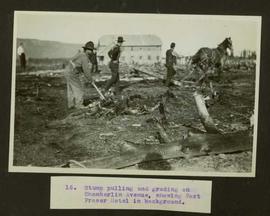
Typed caption glued to album page directly below photograph reads: "16. Stump pulling and grading on Chamberlin Avenue, showing Fort Fraser Hotel in background." Photograph depicts men and a horse working at preparing the land along Chamberlin Avenue. Photographer: Dominion Stock & Bond Corporation.