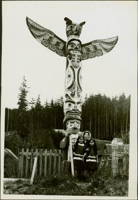
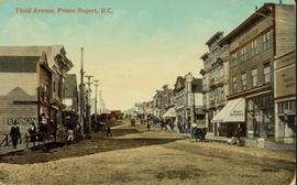
Hand coloured street view of Third Avenue in Prince Rupert, BC. Printed annotation on recto reads: "Third Avenue, Prince Rupert, B.C." Artist's mark in lower left corner reads: "109938 J.V."
Photograph depicts six horses harnessed to a center pole. Three men attend the horses, two men with pitchforks stand atop a wagon loaded with cut grain stocks in the background.
Image depicts three unidentified children standing in the doorway of a house, with two goats ascending the porch steps. The location is uncertain, likely Sinclair Mills, B.C.
Item is a photograph of the three tunnels built to divert the Peace River around the Bennett Dam construction site.
Image depicts a view of the scenery, with three hikers in the bottom left corner of the image.
Image depicts three men and a dog on the hiking trail near Mt. Robson.
Ground level view of the Prince Rupert dry dock. Hills are visible in the background. Printed annotation on recto reads: "Three Million Dollar Dry Dock and Shipbuilding Plant, Prince Rupert, BC."
Officers are mounted on three horses standing in water. Fifth horse stands on right, trees on shore in background. Handwritten annotation on recto of photograph: "Jas Tracey, Vanderhoof. Srg. Birch."
Image depicts three unknown individuals at a campsite.
Image depicts two individuals seated at a picnic table while a third stands closer to the water on a beach somewhere in Kitimat, B.C. What appears to be a harbour can be seen on the water.
Image depicts three individuals and three dogs standing by a stream at an uncertain location, possibly somewhere in Bear Glacier Provincial Park. The woman in purple is possibly Sue Sedgwick.
Image depicts three picnic tables, one of which is occupied with three unknown individuals, on a beach somewhere in Kitimat, B.C.
Photograph features three sternwheelers tied to river bank. Buildings visible on far left, hills on shore visible in background.
Printed annotation on recto reads: “Stern Wheelers 1910 Quesnel B.C.” Handwritten annotation on verso in pencil reads: “BX, B.C. Express, Charlotte”
Handwritten annotation on verso reads: "Poling supplies up Nass River".
Photograph depicts three young, First Nations girls standing in front of a memorial totem pole with houses and a forested environment visible in the background. Photographer’s stamp on verso: “W.E. Nicholson, 268 E. 10th, Vancouver 10, B.C.”
Photograph depicts tall timber and fallen trees.
Photograph depicts lush undergrowth with tall trees.
Photograph depicts lush forest growth and tall trees.
Image depicts Highway 16 en route to Prince Rupert, B.C.
Image depicts a woman standing in a field, with a sign in a tree behind her pointing the way towards the Raven Cabin.
Photograph depicts winding river from above, tall trees on either side and mountains in background. Handwritten photo caption on verso and recto of this photograph reads: "Top of Grand Canyon from Portage trail".
Topographic map depicting regions, communities, unexplored areas, bodies of water, transport routes, and glaciers.
Groups of men and women can be seen gathered on paths between two large totem poles.
Handwritten annotation on verso reads: "Totem Park Pr Rupert park."
Image depicts a totem pole at an uncertain location, possibly in Gitwinksihlkw, B.C.
Photograph depicts a totem pole in a British Columbia rainforest, possibly on Haida Gwaii.
Photograph depicts a totem pole standing on what appears to be a large wooden deck or boardwalk, view of the city in background.
Handwritten annotation on verso reads: "Totem pole in park in Prince Rupert".
Photograph depicts a totem pole standing amidst a forested environment. Handwritten annotations on verso read: “Raven, ?, Sea Lions, Grizzly Bear, Dzondgwa”; “Kwakiutl Pole, Alert Bay & Fort Rupert” photographer’s stamp on verso: “W.E. Nicholson, 268 E. 10th, Vancouver 10, B.C.”
Image depicts several individuals examining totem poles which are possibly undergoing a restoration process somewhere on Haida Gwaii.
Totem poles (crest poles?) stand in front of remains of wood structures built along sandy shore. View from above, forest on hill in background.
Handwritten annotation on verso reads: "[? illegible] Deserted village West Coast QCIs."
Photograph depicts two tall totem poles, buildings and mountain in the background.
Totem poles (crest poles?) stand in front of wooden houses on right. Hills on shoreline visible in background.
Handwritten annotations on verso read: "West Coast QCIs."; "[Old?] Kassan Alaska."
Image depicts a view of the scenery at an uncertain location with numerous individuals, possibly tourists, present. It is possibly somewhere near the Fraser River.
Image depicts a view of the landscape at an unknown location with a group of people, possibly tourists, present. It is possibly near the Fraser River.
Photograph depicts view of snow capped mountains with water in the foreground.
Photograph depicts horse and rope in Fraser River. Hill on opposite shore in background.
Image depicts a tractor with a claw lifting logs at a saw mill in Prince George, B.C.
Photograph depicts an unidentified individual standing on cliff above waterfall at Bulkley River, B.C. Fishing territory visible below; highway, buildings, and hills visible in background.
Photograph depicts fishing territory at waterfall rapids in Bulkley River, B.C. Highway and buildings on opposite shore in background.
Photograph depicts trail making on summit between John Brown and Kitseucla creeks. Survey of 55th parallel.
Image depicts a patch of snow-covered ground with a sign that reads "Trail of 98," somewhere along the White Pass railway.
Photograph of a team of sled dogs pulling a load, followed by a group of men. Mountains are visible in the background. Printed annotation on recto reads: "Trail Over Bitter Creek Glacier to the Naas."
Photograph depicts a tangle of fallen logs and growing trees.
Image depicts Upper Fraser residential area during demolition of town site. Map coordinates 54°06'51.6"N 121°56'26.3"W
Image depicts a train in an uncertain location, though it is possibly Howe Sound in the background.
Image depicts the side of a train and the tracks it is on, somewhere in the Seton Portage area.
Front view of railway train. Fraser Lake believed to be visible in background, behind power lines. Handwritten annotation on recto of mounted slide reads: "Train coming to Lejak [sic]" See also item 2006.20.1.195 for image featuring similar content.