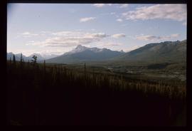
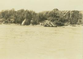
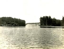
Slide depicts a view of what is possibly the Upper Fraser River.
Image depicts the Upper Fraser Road running through Upper Fraser, B.C. A beehive burner is seen in the background on the left and the mill office is seen on the right. Map coordinates 54°07'05.7"N 121°56'38.9"W
Image depicts several unidentified individuals walking along the snow-covered Upper Fraser Road with numerous buildings on either side. Map coordinates 54°07'05.7"N 121°56'38.9"W
Image depicts an individual standing next to what appears to be the base of a very large, uprooted tree, located somewhere in the coastal forest of Haida Gwaii, B.C.
Image depicts a view of Valemount, with numerous mountains in the background.
Image depicts a view of a mountain range near Valemount, B.C. Valemount is barely visible among the trees on the right side of the image.
Image depicts a view of Valemount with numerous mountains in the background.
Image depicts a distant view of what appears to be a body of water, with numerous mountains in the background. The slide is labelled "Valemount reservoir."
Image depicts a view of a small valley in Mt. Robson Provincial Park.
Image depicts a river running through a valley-like area somewhere near Bralorne, B.C.
Image depicts a valley of fossil beds, possibly the Bulkley Valley.
Photograph depicts a tree-filled valley leading up to a snow-covered mountain range.
Photograph depicts depicts a brush covered valley with tree-covered mountains on either side.
Image depicts an example of varves, an annual layer of sediment or rock, with a pipe used for reference size. It is possibly located at the airport in Prince George, B.C.
Image depicts an example of varves, an annual layer of sediment or rock, possibly located at the airport in Prince George, B.C.
Image depicts a view over a forested, mountainous area and a river somewhere in the area of Skagway, Alaska.
Image depicts a view over a forested, mountainous area and a river towards the vicinity of Skagway, Alaska.
Image depicts a view of the Millar Addition suburb from Connaught Hill in Prince George, B.C.
Photograph depicts the view looking north from Diamond Head Lodge in Garibaldi Park, about 20 miles northeast of Squamish. Believed to be "Bookworm range" at 7910 ft.
Image depicts a view of Prince George from Gunn Point in the L.C. Gunn Park looking north. Map coordinates 53°54'26.2"N 122°43'35.8"W.
Photograph depicts a view of the Peace River leading into a strait flanked by two forested shorelines. In the background a rocky cliffside is visible.
Photograph depicts a view of a snow-covered mountain range.
Photograph depicts a view of cannery buildings from the shoreline with mountains in the background.
Image depicts downtown Prince George taken from across the Nechako River looking south. Map coordinates 53°56'00.0"N 122°44'29.7"W
Photograph depicts the steep slope of man-made embankment, forest in background at bottom of slope. Small twigs and pant leg of unidentified individual in foreground.
Handwritten caption above this photo reads: "Earth Cut". Photograph depicts the steep slope of man-made embankment, trees in background. Tracks made my machinery are visible in dirt of the cut.
Photograph depicts the steep slope of man-made embankment. Forest in background, level excavated ground in foreground.
Photograph depicts the steep slope of man-made embankment, trees in background. Tracks made my machinery are visible in dirt of the cut.
Image depicts a view of Giscome with a train passing through.
Photograph depicts a view of the Hudson's Hope ferry seen from across the river. Behind the ferry, in the background is a rocky cliff face.
Image depicts a view of the small town of Likely, B.C.
No annotation on slide.
Annotation on slide: "Lucille Mt. from Mt. Teare, Susan Stevenson, July 1994"
Photograph depicts a view of a mountainous, tree-covered landscape and valley as seen through a mountain pass.
Image depicts a view of Pine Pass on the border between Alberta and British Columbia in the Rocky Mountains.
Photograph depicts Port Simpson in winter. Water crosses midground, hills stand in background.
Handwritten photo caption below image reads: "Port Simpson".
Annotation on photograph verso: "View SE from Jtn of A Road and Main Road. Uncut stand on left; selection logging virtually complete in centre and right. 15/1/92. Summit Lake Selection Trial"
Image depicts a view of Quesnelle Forks and the nearby river.
Photograph depicts a view of a snow-covered mountain range.