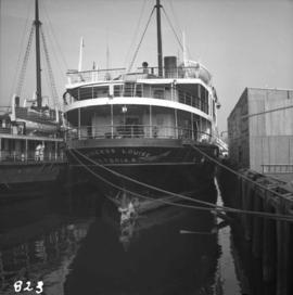
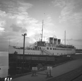
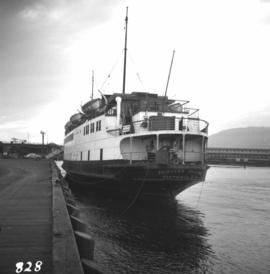
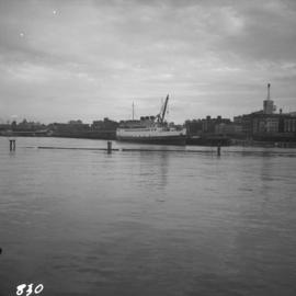
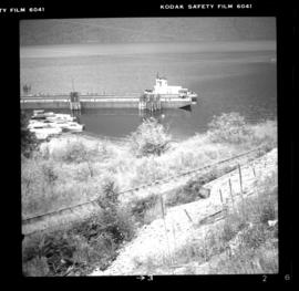
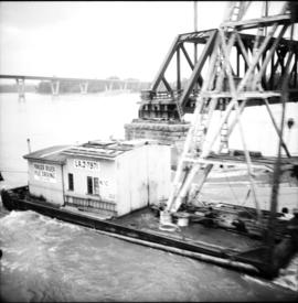
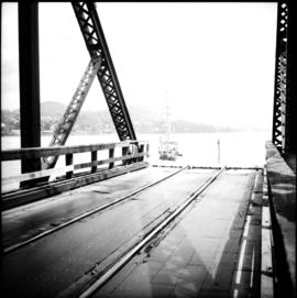
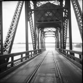
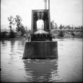
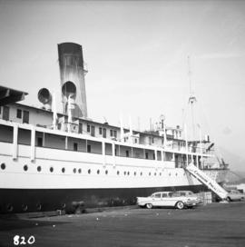
Showing 4073 results

Archival description
CPR "Princess Elaine"
2013.6.36.1.012.08 · Item · [between 1964 and 1966]
Part of David Davies Railway Collection

Photograph depicts a CPR ship named "Princess Elaine" at the pier opposite the CPR station in Vancouver. The ship was being stripped of its engines and was subsequently towed to Blaine, WA.

CPR "Princess Elaine"
2013.6.36.1.012.10 · Item · [between 1964 and 1966]
Part of David Davies Railway Collection

Photograph depicts a CPR ship named "Princess Elaine" at the pier opposite the CPR station in Vancouver. The ship was being stripped of its engines and was subsequently towed to Blaine, WA.

CPR "Princess Elaine"
2013.6.36.1.012.09 · Item · [between 1964 and 1966]
Part of David Davies Railway Collection

Photograph depicts a CPR ship named "Princess Elaine" at the pier opposite the CPR station in Vancouver. The ship was being stripped of its engines and was subsequently towed to Blaine, WA.

CPR "Princess Elaine"
2013.6.36.1.012.11 · Item · [between 1964 and 1966]
Part of David Davies Railway Collection

Photograph depicts a CPR ship named "Princess Elaine" at the pier opposite the CPR station in Vancouver. The ship was being stripped of its engines and was subsequently towed to Blaine, WA.

CPR President's train
2013.6.36.1.120.01 · Item · Aug. 1997
Part of David Davies Railway Collection

Photograph depicts a 3 car train that was ridden by the President of the CPR. Nelson was celebrating its centennial as a municipality and had invited him as an honoured guest. The 3 car train consisted of a sleeper-"Killanney," built in 1916, a Diner-"Assiniboine," built in 1929, and a parlor/observation car-"Mount Stephen," built in 1926.

CPR passing loop at Glenfir
2013.6.36.1.024.09 · Item · 1 Sept. 1970
Part of David Davies Railway Collection

Photograph depicts the CPR passing loop at Glenfir, 15 miles northeast of Penticton on the Carmi Subdivision. The photo shows a way freight train travelling to Penticton at 1pm on a Tuesday. About 2 way freights pass weekly. The grade here is only falling 2.2% and is 1450 ft. above Penticton. This spot is deep in the bush and has a dirt track nearby, but the nearest house is 3 miles away. The view is looking south.

2013.6.36.1.030.15 · Item · Aug. 1943
Part of David Davies Railway Collection

Photograph depicts part of the transfer barge #6 and tug ("Iris G") moved to rail pier with line to Nakusp (to right) in the foreground. It is used once a week or every other week.

CPR ore cars at Nelson
2013.6.36.1.028.38 · Item · 13 Aug. 1983
Part of David Davies Railway Collection

Photograph depicts CPR ore cars at Nelson. These cars are as common to Nelson, as lumber and grain cars are too Kamloops. This is due to the Trail smelter. The high-sided ore car is CN #345098 and it has a capacity of 99 tons and was built in January 1966.

2013.6.36.1.030.07 · Item · Aug. 1983
Part of David Davies Railway Collection

Photograph depicts the northern terminal of barge service on Slocan lake. View of slip looking north. One weekly frieght at this date to Nakus (and return trip). On Thursday, 10 August 1983, south bound return freights consisted of locomotives: 2 flat cars loaded with poles, 2 refrigerators loaded with white pine, and caboose.

CPR Nicola branch line
2013.6.36.1.019.07 · Item · 18 Mar. 1979
Part of David Davies Railway Collection

Photograph depicts the CPR Nicola branch at Nicola terminus, 7 miles east of Merritt. The view is looking west and about 100 yards behind the camera is the end of the rail.

CPR Nicola branch line
2013.6.36.1.019.08 · Item · 18 Mar. 1979
Part of David Davies Railway Collection

Photograph depicts the CPR Nicola branch line at Nicola, near Merritt. The end of the line is adjacent to 2 fir tree at the right edge of the photo. The photo was taken adjacent to the stock yard with a view looking east.

CPR Nicola branch line
2013.6.36.1.019.06 · Item · 18 Mar. 1979
Part of David Davies Railway Collection

Photograph depicts the CPR Nicola branch line at Nicola, near Merritt. The view is looking south beside the stock yard. Turning "Y" used to commence at the road track at the right of the photo. The elevation is 2058 ft.

CPR Nanaimo Station
2013.6.36.1.033.08 · Item · [16 May 1970]
Part of David Davies Railway Collection

Photograph depicts the arrival of the "Dayliner," car #9023. Photograph taken looking northward and at the rear of the train. About 25 passsengers got off at this location, possibly for the May Day parade.

CPR Nanaimo Station
2013.6.36.1.033.11 · Item · [16 May 1970]
Part of David Davies Railway Collection

Photo was taken on mile 72.5. The image captures the arrival of the "Dayliner" from Victoria at 11:00 a.m., looking towards the south. About 25 passengers got off at this location, possibly for the May Day parade.

CPR Nanaimo Station
2013.6.36.1.033.12 · Item · [16 May 1970]
Part of David Davies Railway Collection

Photograph taken at mile 7.2. Arrival of the "Dayliner" at 11:00 captured. Image looking in the north east direction, with the rear of the train nearest the camera. A one way fare from Victoria to Nanaimo is $3.65 and from Nanaimo to Courtenay is $3.40.

CPR Nanaimo Station
2013.6.36.1.033.10 · Item · [16 May 1970]
Part of David Davies Railway Collection

Photograph depicts the arrival of the "Dayliner" on a trip from Victoria to Courtenay. It departs from Victoria at 11:00 a.m. About 25 passengers got off. Photograph taken looking south west.

CPR Nanaimo Depot
2013.6.36.1.033.13 · Item · [16 May 1970]
Part of David Davies Railway Collection

Photograph depicts a close up of the detail of the signals attached to the buildings station. However, it is no longer used.

CPR Nakusp looking west
2013.6.36.1.030.01 · Item · Sept. 1970
Part of David Davies Railway Collection

Photograph depicts rails shown, but also in a pile beyond the "R.H." hut. All are dated 1884, 1885, and 1886. Made variously by Barrow, Blaenaka, Dowlais and Buchum. Has one way freight per week in 1970. Nelson to Rosebury is on Monday. Rosebury to Naksup and then back to Rosebury is on Tuesday. Rosebury to Nelson is on Wednesday. CPR is said to be trying to close Rosebury to Nakusp section of 32.7 miles.

CPR Myra Canyon
2013.6.36.1.154.02 · Item · [between 1993 and 1995]
Part of David Davies Railway Collection

Photograph taken at CPR Myra Canyon. On the 'Save the Trestles' expedition after a line closure at the location.

CPR Myra Canyon
2013.6.36.1.154.04 · Item · [between 1993 and 1995]
Part of David Davies Railway Collection

Photograph taken at CPR Myra Canyon. On the 'Save the Trestles' expedition after a line closure at the location.

CPR Myra Canyon
2013.6.36.1.154.06 · Item · [between 1993 and 1995]
Part of David Davies Railway Collection

Photograph taken at CPR Myra Canyon. On the 'Save the Trestles' expedition after a line closure at the location.

CPR Myra Canyon
2013.6.36.1.154.07 · Item · [between 1993 and 1995]
Part of David Davies Railway Collection

Photograph taken at CPR Myra Canyon. On the 'Save the Trestles' expedition after a line closure at the location.

CPR Myra Canyon
2013.6.36.1.154.01 · Item · [between 1993 and 1995]
Part of David Davies Railway Collection

Photograph taken at CPR Myra Canyon. On the 'Save the Trestles' expedition after a line closure at the location.

CPR Myra Canyon
2013.6.36.1.154.03 · Item · [between 1993 and 1995]
Part of David Davies Railway Collection

Photograph taken at CPR Myra Canyon. On the 'Save the Trestles' expedition after a line closure at the location.

CPR Myra Canyon
2013.6.36.1.154.05 · Item · [between 1993 and 1995]
Part of David Davies Railway Collection

Photograph taken at CPR Myra Canyon. On the 'Save the Trestles' expedition after a line closure at the location.

CPR Myra Canyon
2013.6.36.1.154.08 · Item · [between 1993 and 1995]
Part of David Davies Railway Collection

Photograph taken at CPR Myra Canyon. On the 'Save the Trestles' expedition after a line closure at the location.

CPR "Mount Sicker" signboard
2013.6.36.1.033.01 · Item · [24 May 1967]
Part of David Davies Railway Collection

Photograph depicts a sign board that reads "Mount Sicker." Siding was located about 1 mile south of where this photograph was taken at Westholme Depot. The sign was sighted 5 miles north of Duncan, Vancouver Island. "MS" siding appeared to be taken out. This board was found in a freight shed.

CPR Mission Bridge
2013.6.36.1.017.06 · Item · [3 June 1973]
Part of David Davies Railway Collection

Photograph depicts the CPR Mission Bridge on the Huntingdon branch. The photo was taken from the open swing span looking downstream, with a tug and derrick (Fraser River Pile Driving Co.) fast disappearing downstream. The new road bridge in the background is about to be opened in late June 1973.

CPR Mission Bridge
2013.6.36.1.017.08 · Item · [3 June 1973]
Part of David Davies Railway Collection

Photograph depicts the CPR Mission Bride on the Huntingdon branch. The photo was taken from the open swing, and shows a tug and derrick passing swiftly downstream in the north channel of the opening. The span opens about every 2 or 3 days for river traffic.

CPR Mission Bridge
2013.6.36.1.017.09 · Item · [3 June 1973]
Part of David Davies Railway Collection

Photograph depicts the CPR Mission Bridge on the Huntingdon branch. The span opened to allow downstream passage of a tug and derrick, which passed at about 6 to 8 knots because of the freshet. Tow started at federal wharf at Mission City. The span opens for river traffic every 2 or 3 days. The view is looking east and upstream.

CPR Mission Bridge
2013.6.36.1.017.10 · Item · [3 June 1973]
Part of David Davies Railway Collection

Photograph depicts the CPR Mission Bridge on the Huntingdon branch. The swing span is in an open position and the view is looking west and downstream. A new road bridge to be opened within the month is in the background. The bridge cabin holds a gas engine that turns the span in about 60 seconds.

CPR Mission Bridge
2013.6.36.1.017.07 · Item · [3 June 1973]
Part of David Davies Railway Collection

Photograph depicts the CPR Mission Bridge on the Huntingdon Branch. It shows the final box span of the bridge on the south shore, as viewed from the opened swing span. The span opened for river traffic every 2 or 3 days. The view is looking south, with downstream to the right.

CPR Mission Bridge
2013.6.36.1.017.11 · Item · [3 June 1973]
Part of David Davies Railway Collection

Photograph depicts the CPR Mission Bride on the Huntingdon branch. It shows the receding view of the southbound daily way freight train at about 12:30 hrs. STD time. The train consisted of 2 locomotives, some 35 cars, and this caboose, #436733, built in 1920. The photo was taken from the swing span of the bridge.

CPR Mission Bridge
2013.6.36.1.017.02 · Item · [3 June 1973]
Part of David Davies Railway Collection

Photograph depicts the CPR Mission Bridge on the Huntingdon Branch. The view is looking north from the open swing span. The bridge is about 1700 ft. long and consists of eight 160 ft. tress spans, one 230 ft. swing span, and 3 girder spans. Seven of the eight truss spans are seen in this view, with the Fraser River in freshet.

CPR Mission Bridge
2013.6.36.1.017.03 · Item · [3 June 1973]
Part of David Davies Railway Collection

Photograph depicts the CPR Mission Bridge on the Huntingdon Branch. It shows the daily southbound way freight train at about 12:30 hours STD time, crossing the bridge. The train consisted of two locomotives, about 35 cars, and a 1920 wooden caboose. The lead locomotive was CPR 8510, GM class 0-4-4-0, built in 1954. There is a 10 mph speed restriction on the bridge.

C.P.R. Michel Station
2013.6.36.1.007.105 · Item · Oct. 1965
Part of David Davies Railway Collection

Photograph depicts the C.P.R. Michel Station between Crow's Nest and Fernie. The view is looking west towards the only working colliery left in the district. The station is disused but in good repair.