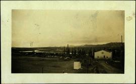
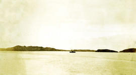
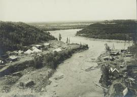
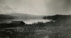
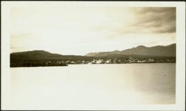
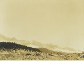
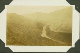
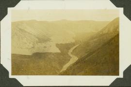
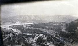
Photograph depicts the confluence of the Cayoosh Creek outflow into the Fraser River in Lillooet, BC. Seton River is visible in the foreground. This area is Cayoose Creek Band (Sekw'el'wás First Nation) territory and includes land currently encompassed within Cayoosh Creek Indian Reserve 1. The Pacific Great Eastern Railway bridge over the Fraser River is also visible in the background.
Photograph depicts a view of cannery buildings from the shoreline with mountains in the background.
Part of a set of 41 original black & white photographs (1908-1914) of the Grand Trunk Pacific Railway line in BC depicting surveying crews, town sites (Prince Rupert and its port, Hazelton and Fort George), and First Nations Peoples. Most of these photos have descriptions written on the back.
Photograph depicts a view of Burns Lake, as seen from the survey crew's temporary lodgings at the cabin of Ben[?] Smith. Wyness notes in the photograph transcription that float planes landed in the bay below the buildings visible in this image.
Photograph taken during European Sports Tour with Team Canada. See also item 2009.6.1.241 for image featuring similar content.
Handwritten annotation on verso reads: "Budapest". See also item 2009.6.1.238 for image featuring similar content. Photograph taken during European Sports Tour with Team Canada.
Photograph taken during European Sports Tour with Team Canada.
Photograph depicts a mountainous area between Bella Coola and Anahim Lake.
Photograph depicts a view of the town site of Britannia Beach from a copper ore bin, above the concentrator.
Photograph depicts a view of cleared valley land with some buildings. Handwritten annotation below the photograph reads, "near Boundary Bay Oct. 1926"
Photograph depicts town in distance, believed to be Atlin, B.C. Lake in foreground, hills in background. See also items 2009.5.2.63 & 2009.5.2.64.
Photograph depicts three men on Asbestos Mountain who are believed to be members of George Edzerza's expedition party during an exploration of the future mine at Cassiar.
Handwritten annotation on verso in blue ink describing sections of photograph which have been pointed to or outlined in blue ink: "LOOKING SOUTH" "ORE ZONE <500' [?] >" "'FLUFF' AREA" "2 MEN" "1 MAN" "OVER -->"
Handwritten annotation on recto in blue ink: "The shaded areas do not indicate 'fluff' necessarily - They are shadows from mountains. The size of the men will give you some indication of the distance".
Photograph depicts three men on Asbestos Mountain who are believed to be members of George Edzerza's expedition party during an exploration of the future mine at Cassiar.
Item is a photograph of a copy print, resulting in a low quality photographic reproduction. Reproduced as a print, slide, and a negative. Location of original photograph is unknown.
Photograph depicts the interior of an airport with seats.
Photograph depicts a view of a snow-covered mountain range.
Photograph depicts a view of fishing boats at Masset.
Photograph depicts the view to the north from the terminal building at the Rainbow Lake Ski Club.
Photograph depicts a view in a lane on the south side of the 1300 block of Richards St. in Vancouver. It includes a Louisville & Nashville car # L&N 109534, that is "paper loading only", has blue paintwork, and was built in June 1953. The end of the spur is at about Drake St. but it is covered in gravel for the last 25 yards. The car was spotted at the Cascade Imperial Mills Ltd. located at #1205 Richards St. Two-thirds of the block is occupied by the Johnston Terminals, Merchandise Storage Division. The building has 6 rail access doors but only 4 are in use. There is usually at least 1 car spotted along the building.
Hand coloured photo of lumber piles and buildings along the edge of the railway. Printed annotation on recto reads: "Prince Rupert, B.C. : View from Wharf Grand Trunk Pacific Railway." Artist's mark in lower left corner reads: "103,110 J.V."
Handwritten photo album caption below this photo reads: "Another view from Tower at Whitehorse." Photograph depicts various unidentified buildings, vehicles, and machinery behind dirt road in mid ground. Power poles in foreground; trees, river, and mountains in background.
Royal Canadian Air ForceCaption: Looking from the track. Fraser River; taken in the early morning hence the shadow. In the dry-belt little vegetation, sage brush, trees only where they catch the snow. Item is a landscape photograph over looking the Fraser River and surrounding canyon.
Caption: Looking from the track. Fraser River; taken in the early morning hence the shadow. In the dry-belt little vegetation, sage brush, trees only where they catch the snow. Item is a landscape photograph over looking the Fraser River and surrounding canyon.
Photograph depicts (from left to right) Bill McPhee, Frank 'Shorty' Weber, and another man resting along the rocky terrain on the west slope of Copper Mountain with a forested area at the base of the mountain. In the background of the image another mountain range is visible. The location of the photograph is noted to be at Copper Mountain; however, that name does not appear to be in current use. Location is assumed to be somewhere in the vicinity of 55.979291, -125.208415, near what is currently named Wasi Peak.
Frank ‘Shorty’ Weber had a trapline on the upper Ingenika for over 30 years. and he was well-known in the Finlay River area.
Photograph depicts a view from the ship the Queen of Powell River, en route from Earl Cove to Saltery Bay.
Photograph depicts a view of the Peace River leading into a strait flanked by two forested shorelines. In the background a rocky cliffside is visible.
Photograph depicts a view from the Pacific Great Eastern mainline, looking east. A spur for logging is at Creekside, showing either Spetch or Mount Currie. The precise location in the photograph is unknown.
Photograph depicts two men (Bill McPhee and Shorty Weber) standing at the summit of Copper Mountain with a snowy mountain range visible in the background of the image.
Photograph depicts open water, a boat is in the centre of the photograph, treed shoreline in the distance. Handwritten annotation below photograph reads, "view from front Shusharti Bay, BC".
Photograph depicts a view of the Prince Rupert grain facility with a docked ship from the railroad tracks.
Photograph depicts a view of the Prince Rupert grain facility from the railroad tracks.
Photograph depicts Two Brothers Lake set within a forested environment with a mountain range visible in the background.
Item is a copyprint reproduced from the British Columbia Forest Service photographic records held at BC Archives.
Photograph depicts a view looking out to the ocean and island. Handwritten annotation below photograph reads, "View off Inverness". Caption may refer to Inverness Cannery on the Skeena River or Inverness Passage.
Photograph depicts the view from the hotel room at Mirror Lake Inn, NY. It is a large tree. Trip is possibly in relation to the 1980 Winter Olympics in Lake Placid, NY.
Hand coloured side view of various buildings along the Grand Trunk Railway waterfront. Printed annotation on recto reads: "Prince Rupert, B.C. : View from Harbor Grand Trunk Pacific Railway." Artist's stamp on lower right corner reads: "103,113 J.V."
Image depicts a view of Prince George from Gunn Point in the L.C. Gunn Park looking north. Map coordinates 53°54'26.2"N 122°43'35.8"W.
Photograph depicts lake in surrounding field. Grave marker on rock in right foreground. Handwritten annotation on recto of photograph: "This is a picture of the lake (part of it) the rock is in the bottom right corner on a knoll. You can see the plaque on it. But it isn't very clear."
Photograph depicts the view looking north from Diamond Head Lodge in Garibaldi Park, about 20 miles northeast of Squamish. Believed to be "Bookworm range" at 7910 ft.