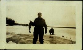
Handwritten photo album caption below this photo reads: "Waiting for the Plane at 'Watson'" Photograph depicts unidentified man standing on ice and holding a fish. The ice in the area behind him has been broken, creating a small pond in the frozen lake. Second man sitting behind pond area. Trees on opposite shore in background.
Royal Canadian Air ForceImage depicts an unidentified individual drilling into the ice.
Image depicts a hand-held ice drill.
Photograph depicts a lofty view of a river with snow and ice on the shore, forest and snowy mountains in the background.
Photograph depicts pieces of ice floating on river, forest trees on either side.
Photograph depicts pieces of ice floating on river, forest trees on either side, hills in distance.
Photograph depicts power plant by waterfall. Extensive construction materials and structures can be seen scattered to left of plant. River in foreground, forest and hills in background. Typed annotation on verso of photograph: "Northern B.C. Power Co. Falls River Plant Prince Rupert B.C."
Image depicts the old log buildings of the town of Hydraulic, B.C.
Image depicts a small grey building, possibly Raven Cabin, sitting at the foot of a ridge.
Image depicts the Raven Lake Hut on the other side of Raven Lake.
Six men stand in small white boat on water close to shore. The four men on left are dressed in formal attire. H. G. T. Perry stands on far left next to Hugh Taylor. Small farm can be seen on shore in midground, treeline and distant hills in background.
Image depicts the W.A.C. Bennett Dam in Hudson's Hope, B.C.
Image depicts the log building that acts as the public library in Hudson's Hope, B.C.
Image depicts what appears to be a motel in Hudson's Hope, B.C. The slide is labelled "camp HH."
Image depicts a street with a building which is labelled "MacKeigan Enterprises Ltd." in Hudson's Hope, B.C.
Image depicts two houses in Hudson's Hope, B.C.
Image depicts an old, three-storey building beside a two-storey hotel in Hudson's Hope, B.C.
Image depicts what appears to be a Fire Hall in Hudson's Hope, B.C.
Image depicts a street in Hudson's Hope, B.C.
Image depicts a road and numerous buildings in Hudson's Hope, B.C.
Image depicts a cabin and several other buildings, possibly located in Hudson's Hope, B.C.
Postcard featuring the Fort St. James HBC Post. Printed annotation on recto reads: "H.B.C. Post Ft. St. James."
Photograph depicts view looking down railroad tracks toward a snow capped mountain. Survey of 55th parallel.
Photograph depicts ten men standing on a boardwalk outside a large building. Another building, boardwalks and fences nearby. Forest in the background. The buildings are constructed from lumber.
Photograph depicts a large white building surrounded by a fence.
Photograph depicts a cluster of seven or more buildings, fences and a flag pole. A grassy field in the foreground, rolling hills in the background.
Photograph depicts buildings, field, and fenced areas with forest in the background.
Image depicts a view of Howe Sound from the Stawamus Chief Nature Trail to the Stawamus Chief Mountain, which is often incorrectly referred to as "Squamish" Chief.
Image depicts the Britannia Mine, which closed in 1974 and is now a museum. "Anaconda" was the last operating owner.
Image depicts Howe Sound.
Image depicts a number of houses built on stilts over a body of water in an uncertain location.
View of peninsula with houses and trees. Dock in mid ground, trees and grasses in foreground. Recto stamped “Port Simpson DE 17" and "Port Essington DE 18". Handwritten annotation on recto of photograph: "W. J. O'Neill Esq. Telegraph Point Via Pt. Essington B.C. Don't you think this pretty [Weggs & Mr. Byron?] was over last night - said he saw you and [Halie?]. Yours - BaBa".
Image depicts a row of houses in Upper Fraser, B.C. Map coordinates 54°06'51.6"N 121°56'26.3"W
Image depicts the Giscome B.C. townsite from across the railroad tracks looking southeast. Map coordinates 54°04'19.7"N 122°22'04.7"W
Image depicts several houses, and three goats standing on a narrow dirt road. The location is uncertain, likely Sinclair Mills, B.C.
Image depicts a view of numerous houses and a ballpark at an uncertain location. It is possibly located somewhere in the Peace River Region.
Image depicts numerous houses, and an unknown child standing in a street at Island Cache.
Image depicts a few houses in Island Cache.
Image depicts a few houses and a dog on a porch at Island Cache.
Image depicts a set of train tracks, a farmhouse, and some fields; possibly in Woodpecker, B.C.
Image depicts a house with ivy growing over it. The location is uncertain.
Image depicts a house with some Firts Nations' art painted on the front, somewhere on Haida Gwaii, B.C.
Image depicts a house being removed from Upper Fraser, B.C. during demolition of town site. A sign on the house reads: "Murray Blackwell House Raising & Moving." Map coordinates 54°06'51.6"N 121°56'26.3"W
Image depicts a house on the shore somewhere on Haida Gwaii.
Image depicts and old house and vehicle in Upper Fraser, B.C. Map coordinates 54°07'05.7"N 121°56'38.9"W
Image depicts a small house with brightly coloured door and window frames in Penny, B.C.