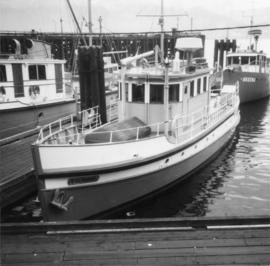
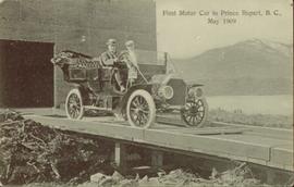
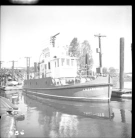
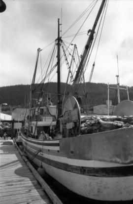
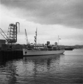
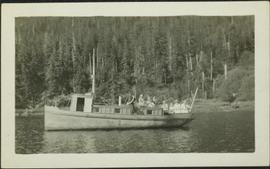
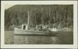
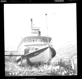
Photograph depicts an unidentified fishing boat at the Prince Rupert marina. An unidentified person stands beside a building in the far background.
Image depicts numerous boats docked by a buildings identified as the "Prince Rupert Fishermen's Co-operative Association."
Photograph depicts fisheries protection and examination vessels.
Photograph of a team of sled dogs resting while a group of people rest around them. Printed annotation on recto reads: "First White Woman to Cross to the Naas #97."
Photograph of a large crowd gathered in front of a Grand Trunk Pacific train. Residential buildings atop a hill are visible in the background. Annotation on recto reads: "First Train Leaving Prince Rupert June 14 1911"
Photograph of a mustachioed man perched atop a cart load of lumber hitched to a team of horses. Annotation on recto reads: "First Team Hitched Up at Prince Rupert May 1908."
Photograph depicts a road crossing (to Jura and Osprey Lake), northeast of Princeton.
Photograph depicts a road crossing (to Jura and Osprey Lake), northeast of Princeton. Looking downgrade into Princeton Valley.
Pile driver situated on Prince Rupert shoreline. Tents and wooden buildings visible on rocky background. Printed annotations on recto of photograph read: "First pile driven at Prince Rupert BC. June 8 '06."
Head on shot of steam engine traveling through a pass with mountains in the background. Handwritten annotation in pen on verso reads: "First Passenger Engine to reach Prince Rupert." Annotation on recto reads: "First Passenger Engine at Prince Rupert." Photographer' stamp in bottom right corner of recto reads : "Allen Photo."
This original film footage clip depicts depicts the first Pacific Great Eastern Railway (PGE) revenue train running south from Fort Nelson with Premier Bennett, September 1971.
Photograph depicts a First Nations dugout canoe at Lillooet, BCIt is about 10 ft. long.
Photograph of two men in a car driving down a wooden road in Prince Rupert, BC. Printed annotation on recto reads: "First Motor Car in Prince Rupert, B.C., May 1909." Handwritten annotation on verso reads: "Milwaukee Ore. Nov 7 1913. Dear Friends. Just a line. We are comming[sic] over Sunday if it don't rain to[sic] hard. How is Fredie? Hope he is alright. If you had other plans for Sunday you can phone us. Best regards from us both. Mrs Ed Herry[??]." Postcard is addressed to: "Mrs. J Reichard 3404 34 L. St. Vancouver Wash." Verso is affixed with a one cent American stamp. Postmark reads: "Milwaukee [illegible] Oreg."
Photograph depicts a CPR firefighting water tank placed on a flatcar, which was the ex tender of a steam locomotive. The service car is #415391 and the pump is at the left, beyond the photo.
Photograph depicts "Fireboat" that was built for the Nanaimo-Vancouver Bath-Tub Race. The race had terminated at Fisherman's cove on the same day.
Photograph depicts a fire float at False Creek. It is one of the two operated by the Vancouver Fire Department in Vancouver.
Image depicts numerous tractors at Finning Tractor and Equipment Co. Ltd. located along Highway 97 in Prince George, B.C.
Item is a photograph of Percy Gray and pilot Ian Watt gassing up their plane at Finlay Forks before continuing their survey of the Rocky Mountain Trench in March 1957.
Image depicts the intersection of 5th Ave and Highway 97 looking northeast. Map coordinates 53°55'14.0"N 122°46'54.8"W
Photograph depicts a field roller made out of logs.
Image depicts a ferry entering Horseshoe Bay in the Howe Sound region.
Photograph depicts a ferry barge and tug operated by the Department of Highways.
Photograph depicts a ferry barge and tug that was docked on the maindland side of Barnston Island.
Photograph depicts a wooden ferry being steered by one man with two men waiting on a rocky shoreline. Annotation on verso of photograph states: "Ferry across Kishpiax at Hazelton"
Photograph depicts the Fernie CPR station, located at mile 34.7 on the Cranbrook Subdivision, which runs from Crowsnest to Cranbrook. In coal mining days this was a busy place but now it has sidings for 153 cars and nothing else. The view is looking east.
Photograph depicts the Federal Railway Bridge in New Westminster. Its span had been knocked down by an unmanned scow. New span was to be floated in on by April 22, 1976.
Photograph depicts the Federal Railway Bridge in New Westminster. It had been knocked down by a runaway scow. The new span was to be built and installed by April 22, 1976.
Photograph taken at Nanaimo's lumber and general cargo wharf. Displayed is a federal government survey vessel, "W.M. J Stewart," that was registerd in Ottawa, but was built in Ontario. Davies suggests that it may have been surveying shallow and coastal river waters about 2 miles south of Nanaimo since survey stakes were visible.
Photograph depicts the federal government paddle steam sternwheeler "Samson V" at New Westminster. It is used daily on the Fraser River to lift and move buoys etc. It was built in 1937 at New Westminster. It operates between the mouth of the Fraser and Mission. Its crew of 10 is made up of a captain, mate, bosun, two deckhands, cook, steward, chief engineer, greaser, and engineer. It is kept in excellent shape, inside and out.
Photograph depicts the stern wheel of the federal government steamer "Samson V," tied up at New Westminster.
Photograph depicts the federal government paddle steam sternwheeler "Samson V" at New Westminster. The boiler room is the fore part of the lower deck.
Photograph taken in the KVR Princeton Subdivision. Depicts the Faulder loop/siding, showing its west switch at the centre of a tree edge. Located on mile 16, but in a timetable said to be on mile 15.5. Siding took 70 cars and was 2/3 of a mile, which made the east switch on mile 15.3. This made mile 15.5 at the small wayside depot/waiting room. Beyond the level twin tracks of Faulder, the railway climbed upgrade towards the west.
Photograph depicts men, women, and children sitting on deck near stern of what appears to be a small riverboat. A man wearing overalls stands on side deck. Water in foreground, trees on hillside in background.
Photograph depicts the control panel of a Fairmont 2 man track car. Belt transmission.
Photograph depicts equipment that says "Fairmont Tamper," but Davies states that it must be a ballast reclaimer and screener.
Photograph depicts a Fairmont speeder, lettered KVR, owned by Kettle Valley Steam Railway.
Photograph depicts an ex-locomotive tender, now a mobile water tank at the Canadian National Railway (CN) depot at Spences Bridge. The mobile water tank holds 11, 600 gallons.
Photograph depicts the existing south end of Rosebury to Nakusp branch. Line extends for 1/4 mile to booming ground/sawmill. Beach Lake was former building site of CPR steamers/scows. Rails are: Cammell 1901, Lorain 1902, Barrow 1903. All weigh 85 Ibs. The branch used to extend 3 1/2 miles to New Denver, but pulled up in 1982.
Photograph depicts the ex CPR Coquihalla Line, looking northeast between Iago and Romeo depots, at about mile 29 from Brookmere. The tunnel was built of concrete and the west end was blocked by a rock fall in 1971. The grade is now used by auto traffic, which is about 20-50 cars per day in summer weekends. The grade at this point is 1 in 49.
Photograph depicts the ex CPR Coquihalla Line of the Kettle Valley Railway. This is one of the several tunnels on the line. The short tunnel is about 50 yards. The entrance on this side was faced in concrete in 1944. Inside the raw rock is supported by steel or wooden beams and the north portal is faced with timbers. It is now used by cars. It is about 1 mile north of Iago Depot. The view is looking north at about mile 28.5 from Brookmere, BC.
Photograph depicts the excavation area in forest where dragline cranes had been operating.
Photograph depicts the ex C.P.R. "Moyie" sternwheeler, now a museum at Kaslo.
Photograph depicts the ex CPR Glenwalker station on the Merritt Subdivision. It is located at mile 49.2 from Spences Bridge and used to consist of a passing loop, spur, and section house. The sign is located in the yard of a ranch belonging to the Glenwalker Cattle Co. Ltd.
Photograph depicts the ex CPR Coquihalla Line of the Kettle Valley Railway. The view is looking northeast, between Iago and Romeo depots at about mile 29 from Brookmere. There was a rock fall at the west portal in 1971. The line closed abruptly on 23 November 1959, after a massive washout near Jessica. The grade at this point is 1 in 49.
Photograph depicts an ex Canmore Mines Ltd. 0-6-0 locomotive located at Heritage Park in Calgary. Internally, the locomotive is gutted and is chain-driven on the rear axle by a caterpillar tractor engine mounted inside the boiler.
Photograph depicts the Esquimalt and Nanaimo Railway on the south outskirts of Nanaimo by the former Chinatown. The view is looking north.
Photograph taken at about mile 53 between Chemainus and Ladysmith at Victoria Road (plantation). Image captured looking towards the south.
Photograph taken at about mile 53 between Chemainus and Ladysmith at Victoria Road (plantation). Image captured looking towards the north.
Photograph depicts rail lines of the Esquimalt & Nanaimo Railway. Location is not certain.