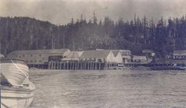
Photograph depicts a cannery on wood pilings with several other buildings along a forested shoreline with a body of water and boat in the foreground.
Image depicts what is possibly the Nass River.
Image depicts the Nass River from a bridge at an uncertain location.
Image depicts a bridge over the Nass River.
Image depicts a south-west view of the Nass Valley.
Image depicts a camper parked on the shore of Nation Lakes, south of Manson Creek, B.C.
Image depicts the Nation River somewhere south of Manson Creek, B.C.
Image depicts a bridge over the Nation River somewhere south of Manson Creek, B.C.
Image depicts natural meadows, possibly east of Prince Georg, B.C.
Photograph depicts natural springs falling down a rocky slope found below Hudson's Hope, upriver from Ferry Landing. In the background of the image a forested area rises above the rocky slope.
Image depicts a nature trail on Cottonwood Island.
Image depicts Nautley and the Nautley River near Fraser Lake, B.C.
Image depicts numerous trees damaged by beavers near the Nautley River.
Image depicts the entrance of the Nautley River in Fort Fraser, B.C.
Image depicts an old, collapsing house at the Nautley site in Fort Fraser, B.C.
Image depicts a couple of old, collapsing buildings at the Nautley site in Fort Fraser, B.C.
Image depicts a stretch of land from Highway 97 near 100 Mile House, B.C.
Image depicts a view of a river near Bralorne, B.C.
Image depicts a river somewhere near Bralorne, B.C.
Image depicts an elevated view of a river near Bralorne, B.C.
Image depicts a river somewhere near Bralorne, B.C.
Image depicts a dirt road somewhere near Bralorne, B.C.
Image depicts a view of the land surrounding Bralorne, B.C.
Image depicts a section of land from Highway 97 near Cache Creek, B.C.
Image depicts a forest and a road, somewhere near Duffey Lake.
Image depicts the Duffey Lake Provincial Park.
Image depicts a road somewhere near Duffey Lake.
Image depicts the Duffey Lake Provincial Park.
Image depicts an aerial view of a stretch of road near the Fraser Bridge.
Image depicts a field somewhere near Grassy Plains, B.C.
Image depicts a road and field somewhere near Grassy Plains, B.C.
Image depicts the Fraser River near Lillooet, B.C.
Image depicts a view of the scenery near Lillooet, B.C.
Image depicts a view of either the Rocky Mountains or possibly the Columbia Mountains near McBride, B.C.
Image depicts a house located somewhere near McBride, B.C.
Image depicts a view of what is most likely the Rocky Mountains near McBride, B.C.
Image depicts a view of what is either the Rocky Mountains or possibly the Columbia Mountains near McBride, B.C.