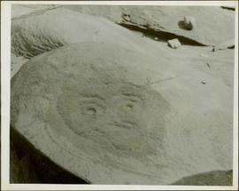
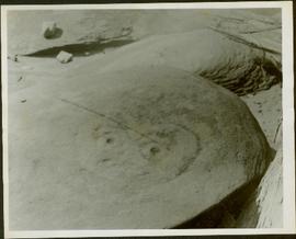
Photograph depicts a Kwakiutl petroglyph in Fort Rupert near Port Hardy. Handwritten annotations on verso reads: “Reversed negative, dry rock, 1957”; “Dry Rock, 1957”
Photograph depicts a Kwakiutl petroglyph exposed at low tide in Fort Rupert near Port Hardy. Handwritten annotations on verso read: “1957 Port Hardy, visible at low tide”; “Right negative, rock (?) Port Hardy visible at low tide”
Image depicts the Lajoie Dam on the Bridge River, upstream side, showing part of Downton Lake and, in the foreground, the spillway intake.
Image depicts the Lajoie Dam on the Bridge River from the upstream side.
Image depicts the Lajoie hydroelectric generating station at the Lajoie Dam on the Bridge River (view of powerhouse and tailrace from top of dam).
Image depicts a lake with numerous buildings along the shore. The location is uncertain.
Image depicts a lake with lily pads somewhere on Haida Gwaii.
Image depicts a lake with a "Swim at Own Risk" sign at an uncertain location.
Image depicts a lake and a cabin at an uncertain location.
Image depicts an aerial view of a lake and large, forested areas. The location is uncertain.
Image depicts a lake and a mountain in the distance. The location is uncertain.
Image depicts an aerial view of a lake, and what appears to be a set of railway tracks running towards the mountains in the distance. The location is uncertain.
Image depicts an aerial view of several lakes and their surrounding areas at an uncertain location.
Image depicts an aerial view of a lake and the surrounding area at an uncertain location.
Photograph depicts a body of water with trees on opposite bank crossing mid ground. Trees and rocks in foreground, hills visible in distant background. Handwritten photo caption below photograph reads: "Lake Beau Vert."
Photograph depicts a large body of water with trees on opposite bank crossing mid ground and reflected in the water. Mountains visible in distant background. Handwritten photo caption below photograph reads: "Lake Beau Vert and Whistler Mt Jasper Park."
Photograph depicts a glassy body of water with trees on opposite bank crossing mid ground. Mountains visible in distant background. A clear reflection of the trees and mountains is mirrored in the water. Handwritten photo caption below photograph reads: "The Whistlers across Lake Beau Vert (7. AM.)"
Photograph depicts trees on water shore, lake in foreground, mountain in background. See also item 2009.5.2.80.
Photograph depicts trees on water shore, lake in foreground, mountain in background. See also item 2009.5.2.79.
Photograph depicts a large lake, trees in foreground, mountains in background. Area speculated to be near Atlin, B.C. Handwritten annotations on recto of photograph: "36", "Aug 3 on way to A '[Homell?]'."
Photograph depicts a small inland lake, trees and low hills border the lake.
Image depicts a camper on the shore of what is possibly Melita Lake, near the Tseax Cone.
Image depicts a large group of people enjoying the Mount Layton Hot springs in the Lakelse Lake Provincial Park north of Kitimat, B.C.
Image depicts a boarded-up house in Lamming Mills, B.C.
Image depicts an old, boarded-up store/office in Lamming Mills, B.C.
Image depicts the old, boarded-up community hall in Lamming Mills, B.C.
Image depicts several boarded-up houses in Lamming Mills, B.C.
Image depicts several old houses and an old, yellow pick-up in Lamming Mills, B.C.
Image depicts what appears to be the old, abandoned mill in Lamming Mills, B.C.
Image depicts what appears to be a part of the old, abandoned mill in Lamming Mills, B.C.
Image depicts a Yellowhead Realty sign in Lamming Mills, B.C. It reads: "For Sale, entire community, 50 buildings, 60 acres."
Image depicts a small section of the area surrounding Lamming Mills, B.C.
Photograph depicts land clearance between Monashee Pass and Lumby, B.C.
Photograph depicts one man standing on the bank of a river, forest in the background. The image is not in focus or possibly a double exposure.
Image depicts a view of a mountainous landscape at an uncertain location.
Image depicts a view of the landscape in an uncertain location, though possibly somewhere near the Fraser River.
Image depicts a view of the landscape of the Chilcotin Wildlife Area.
Image depicts a view of the landscape in an uncertain location.
Image depicts an aerial view of a landscape at an uncertain location.
Image depicts an aerial view of the land near the Fraser River.
Image depicts a view of a mountainous landscape, possibly near the Fraser River.
Image depicts the rolling hills of the Chilcotin Wildlife Area.
Landscape with stumps, and roadbed with small (railroad?) track in foreground. River crosses midground, trees and sky in background. Men can be seen standing on far right on raised roadbed.
Image depicts what is possibly the remaining traces of a small land or rock slide; located somewhere near Bralorne, B.C.
Image depicts the snow still remaining from an avalanche at Lanezi Lake. Two people are also seen canoeing on the lake.
Image depicts a cirque in the mountains surrounding Lanezi Lake. Two individuals can also be seen canoeing on the lake.