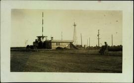
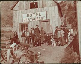
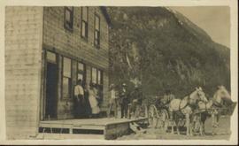
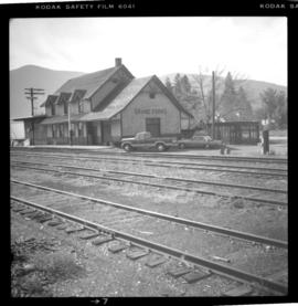
Photograph depicts the Grand Central Hotel at the intersection of Marpole Ave and Hudson St. in south Vancouver. The hotel was built in 1912 by J.J. Graver and run from 1913-1915. It re-opened in 1920 as a home for incurables (veterans). In 1937 it became the provincial infirmary and closed in May 1965.
Photograph depicts the Grand Forks CPR depot, located at mile 94.8 on the Boundary Subdivision, which runs from Nelson to Midway (127 miles). It was originally built by the Columbia & Western Railway in 1899. IT has not seen a passenger train in years but it is still in use for administrative purposes.
Image depicts the Fraser River and the Grand Trunk Pacific Bridge from Cottonwood Island Park.
Photograph depicts what appears to be two trains and a long building on high level of river bank. Fraser river in foreground, forest trees on shore in background.
Photograph depicts a train and long building on high level of river bank. Fraser river in foreground, forest trees on shore in background.
Photograph depicts group of buildings at Grande Prairie airstrip. The foremost building has the sign "YUKON SOUTHERN" on its roof, and the tower and admin building can be seen behind. Power poles, large trucks, and other large unidentified machinery are lined up in background on right.
Royal Canadian Air ForcePhotograph depicts building with small second story attached, and a tall red and white pole in front. Signal tower and power poles in background on right, semi-trailer in background on left. A man in uniform can be seen in the far right sitting on a small staircase on wheels. Small unidentified buildings and miscellaneous shop supplies in background. Handwritten photo album caption beside this photo reads: "Grand Prairie Tower and Adm. Bldg."
Royal Canadian Air ForceImage depicts a row of houses in Granduc, near the Granduc Mine and located north of Stewart, B.C.
Image depicts a row of boarded up houses in Granduc, near the Granduc Mine and located north of Stewart, B.C.
Image depicts housing in Granduc, near the Granduc Mine and located north of Stewart, B.C.
Image depicts an example of "typical housing" in Granduc, near the Granduc Mine and located north of Stewart, B.C.
Image depicts Grassy Plains, B.C.
Image depicts the grave of W.L. Meason in the upper Fraser Canyon.
Image depicts numerous grave markers at an uncertain location.
Image depicts a small graveyard at an uncertain location.
Photograph depicts the rear of the Great Northern depot on Main St. in Vancouver, that is now demolished.
Photograph depicts the Great Northern Railway depot at Keremeos and the terminus of the line from Wenatchee, Washington, U.S.A. The line stops about 1/3 mile beyond this point. At one time it ran on to Hedley mine and possibly Princeton.
Photograph depicts the Great Northern Railway former station at Cascade, just north of the Canada-U.S. border and 15 miles east of Grand Forks. The line connects Kettle Falls and Grand Forks, but the station is now disused but in good repair. The view is looking south towards Washington State.
Photograph depicts a lighthouse on a rocky island with water in the foreground. Annotation on verso of photograph states: "Dear Dr. Thanks for the cheque received yesterday. Christmas Greetings. Yours Sincerely Mr. Cruickshank (?) Green Island"
Greenhouses stand in front of house in field, hills in background.
Greeting card reads: "Kincolith Church. Wishing you all a very happy Xmas. Your work shall be rewarded. II Chron. XV. 7. [illegible initials]".
Photograph depicts the interior of a grocery shop displaying eggs, scale, sides of meat, bananas, other produce and 2 shop attendants. Sign above table reads: Morrow & Frizzell. Handwritten annotation in pencil on recto reads: “Port Essington B. C. 1907”.
Photograph depicts a grocery store on the main street of Pitt Meadows in the Fraser Valley.
Ground level view of the Prince Rupert dry dock during what appears to be construction. Printed annotation on recto reads: "The Dry Dock of Prince Rupert."
Ground level view of the dry dock in Prince Rupert, BC. Printed annotation on recto reads: "Dry Dock Prince Rupert BC McRae Bros."
Photograph depicts two women with flowers and three men standing on grass and boardwalk in foreground, large building in background.
Handwritten annotation on verso: “Government Agency at S. Fort George 1922."
Photograph depicts group of working men and 6 dogs standing outside wood building. Hill in background.
Photograph depicts small buildings with canvas roofs and signs reading: "Do Drop In, Ladies & Gents Furnishings Boots & Shoes, Two Per Cent Beer." One woman, nine men,and three dogs can be seen in image.
Handwritten annotation on verso: “Prairie Creek 1912".
Group of eight men and seven children stand in front of crest pole on unidentified building.
Handwritten annotation below image reads: "[..?] Alaska. Indian Totem Pole, Eagle Crest South Eastern Alaska."; on verso: "Chapter XXI Illustrations No. 2. [Kinnanook?] Section of Indian Village showing Totem pole of Eagle crest."
Photograph depicts large group posed on ceremonial steps in Agora courtyard at the University of Northern British Columbia in Prince George, B.C. Most individuals in group wear regalia. Bridget Moran appears to be standing in center of second row, hand raised to her face.
Photograph is a printed postcard depicting a team of horses harnessed to a buckboard; a group of people standing on a platform outside a building near Stewart B.C. There are mountains in the background.
Image depicts a large group of people in a room at an uncertain location in the Peace River Region.
Image depicts a group of individuals standing on the corner of 3rd Ave in Prince George, B.C.
Photograph depicts a group portrait of Iona Campagnolo with construction workers at a building site, possibly for a Young Canada Works project.
Photograph depicts a group portrait of Iona Campagnolo with construction workers laughing at a building site, possibly for a Young Canada Works project.
Image depicts the Grand Trunk Pacific railway roundhouse in Prince George, B.C.
Image depicts the GTP roundhouse in Prince George, B.C.
Image depicts the Grand Trunk Pacific railway roundhouse in Prince George, B.C.
Image depicts the interior of the GTP roundhouse in Prince George, B.C.
Image depicts machinery in the GTP roundhouse in Prince George, B.C.
Image depicts a bridge in Hagwilget, B.C.
Image depicts a church on a hill in Hagwilget, B.C.
Close view of bridge built with wooden planks, poles, and wires, braced from below, with triangles built into its frame. The bridge crosses Hagwilget Canyon on the Bulkley River, five kilometres from its confluence with the Skeena River. This is one of the many bridge structures that have crossed this location since at least 1859. Photograph was taken from one side of canyon, near bridge. Opposite canyon wall in background. Typed annotation glued to verso of photograph: "HAGWILGET - 'the gentle or quiet people'."