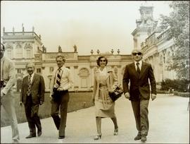
Showing 3211 results

Archival description
2011.12.02 · Item · ca. 1950
Part of Giscome, BC Historical Photograph collection

Photo depicts a street perspective of George St., in Prince George, BC, ca. 1950. Annotation recto reads: "George St. Prince George BC Photo by J Wrathall." Handwritten annotation in pen on verso of postcard reads: “This is the Hastings Street of Prince George. This & 3rd Streets are the main thoroughfares.”

George Street
2012.13.1.7.220 · Item · May 2001
Part of J. Kent Sedgwick fonds

Image depicts a view of George Street with the Prince George City Hall at the corner of George Street and 7th Avenue.

2009.5.3.82 · Item · [ca. 1950]
Part of Taylor-Baxter Family Photograph Collection

Handwritten annotation on verso of photograph reads: "George St. Prince George BC Photo. S Wrathall". Prince George Hotel and Cafe stand on left side of street in foreground, and many other buildings and businesses can be seen. Vehicles line the street, cut banks visible in background. Photograph believed to have been taken while George Street was being prepared for a new lawyer of asphalt.

Germansen Landing
2012.13.1.71.01 · Item · 1979
Part of J. Kent Sedgwick fonds

Image depicts the Germansen River, with the buildings of Germansen Landing visible on the other side.

Ginter House
2012.13.1.14.03 · Item · Dec. 1997
Part of J. Kent Sedgwick fonds

Image depicts the Ginter House and the surrounding woods, in Prince George, B.C.

Giscome
2012.13.1.87.175 · Item · [between 1975 and 1995]
Part of J. Kent Sedgwick fonds

Image depicts the Giscome, B.C. town site with the Giscome railway station and the Giscome store in the center surrounded by vehicles. Map coordinates 54°04'18.5"N 122°21'57.7"W

Giscome - Church
2012.13.1.87.099 · Item · [between 1975 and 1995]
Part of J. Kent Sedgwick fonds

Image depicts a church in Giscome, B.C. Map coordinates 54°04'16.2"N 122°21'54.3"W

Giscome - Eaglet Lake
2012.13.1.87.090 · Item · [between 1980 and 2000]
Part of J. Kent Sedgwick fonds

Image depicts mill site and dock in Giscome, B.C. with Eaglet Lake in the background covered in ice. There is a large crowd of people gathered near the dock. Map coordinates 54°04'34.9"N 122°21'50.0"W

Giscome - Power Poles
2012.13.1.87.098 · Item · [between 1975 and 1995]
Part of J. Kent Sedgwick fonds

Image depicts the remains of a street of houses in Giscome, B.C. The quarry is slightly visible in the background. Map coordinates 54°04'20.9"N 122°21'53.1"W

2012.13.1.87.086 · Item · [between 1980 and 2000]
Part of J. Kent Sedgwick fonds

Image depicts the Giscome mill site in Giscome, B.C. The bunkhouse is the large building with many windows. A train and railroad tracks are in the foreground. Map coordinates 54°04'17.6"N 122°22'06.1"W

Giscome Bunkhouse
2012.13.1.87.158 · Item · [between 1975 and 1995]
Part of J. Kent Sedgwick fonds

Image depicts the Giscome bunkhouse in Giscome, B.C. Map coordinates 54°04'17.6"N 122°22'06.1"W

Giscome CN Station
2012.13.1.87.161 · Item · [between 1975 and 1995]
Part of J. Kent Sedgwick fonds

Image depicts the old CN station in Giscome, B.C. Map coordinates 54°04'20.7"N 122°22'01.1"W