Photograph depicts several cannery buildings on pilings with water in the foreground and a forested area in the background.
Photograph depicts six adults and three or more children sitting on the ground with a log cabin in the background. Snow scatters the ground in small patches.
Photograph depicts a woman and two men standing outdoors near a newly constructed log cabin. Tree stumps in foreground, forest in background.
Photograph depicts a small one window cabin within a rustic clearing. There is a fenced area (possibly garden) near the cabin and forest in the background.
Photograph depicts a man and a woman standing in front of a log home and nearby shed. There are stumps in the foreground and tall timber in the background.
Photograph depicts the rooftops of four wood buildings behind bushes on opposite shore. Forest trees in background. These buildings are speculated to be a Bourchier forestry camp.
Photograph depicts the steam-operated sawmill at Seton Lake and a fish weir at the mouth of the creek. The railway grade alongside the lake, constructed circa 1914-1915, is visible in the background. The Seton Lake fish hatchery, which built and used the fish weir, ceased operations in 1915, dating this photograph sometime around 1914 or 1915.
Photograph depicts the steam-operated Durban & Sons sawmill at the east end of Seton Lake. This photograph was taken before the PGE railway grade was built alongside the lake circa 1914-1915.
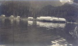
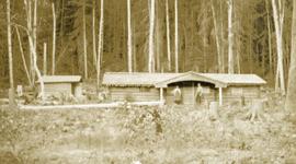
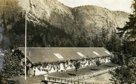
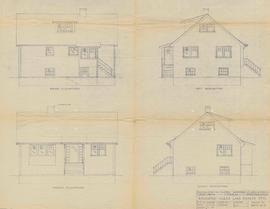
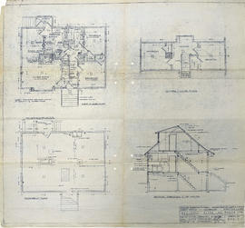
Photograph depicts the Seton Lake hatchery building constructed by the British Columbia provincial government in 1903.
Additional photographs and information about this construction is provided in the Fisheries Commissioner's Report for that year:
"In October, 1902, bids were invited for the construction of a hatchery building and Superintendent's cottage on Lake Creek, the outlet of Seton Lake, near the village of Lillooet. There were six bidders. A contract was let to W. Duguid, of Lillooet, the lowest bidder, in November. The buildings were completed and accepted in March, 1903. The hatchery building is a substantial wooden structure 210 feet long by 40 feet wide. The roof is supported by the walls, thus giving a clear floor space for the 160 hatching troughs, which are each 16 feet long, 16 inches wide and 7 inches deep. Two troughs are placed end to end and extend the width of the building, and receive the water from the head flumes which run lengthwise of the building. The equipment permits of the handling of forty million eggs. The water supply is taken from Lake Creek at a point some 1,400 feet from the hatchery, and about the same distance from Seton Lake, by means of a wooden flume three feet wide and two feet deep. A comfortable cottage for the Superintendent and a boarding-house for the other employees were constructed and furnished. The station in all its equipment is modern, and is not excelled by any other on the coast..."
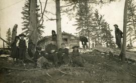
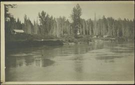
Hatchery operations were terminated in Seton Creek in 1915 because the salmon runs had been almost destroyed.
Item is a photograph of a self-dumping log barge in action.
Item is an original Silvicultural Research Note on"Selective Logging of Spruce in Sub-Alpine Alberta" by L.A. DeGrace.
Item is an original issue of British Columbia Forest Service Research Notes on "Seed Production of Hemlock and Cedar in the Interior Wet Belt Region of British Columbia related to Dispersal and Regeneration".
Photograph depicts a section of cleared bedrock along a steep ditch.
Original photographic print included in "Northern Interior Forest Experiment Station: Report of Preliminary Investigations" by Percy Barr.
Item is a photograph of a copy print, resulting in a low quality photographic reproduction. Reproduced as a print, slide, and a negative. Location of original photograph is unknown.
Photograph is a copy print.
Item is an issue of "Forest Management Notes" on "Scarification in the Spruce Alpine Fir type of the Prince George Forest District" by J.R. Gilmour and J. Konishi.
Item is a copyprint reproduced from the British Columbia Forest Service photographic records held at BC Archives.
Caption describing photograph: "See GBW Film 3 Frame 3 (2007.1.30.2.027) for details."
Caption describing photograph: "Scarification after logging (clear cut). East Loop Road. F.E.S. Aleza Lake. Sandy silt. O site." Harry Coates stands in the photograph for scale.
Photograph depicts two men at a sawmill. A beehive burner is in the background.
Photograph depicts a sawmill with a dry kiln next to a rail line. The location and name of the sawmill is unknown.
Slide depicts a sawmill in operation, likely located in the Upper Fraser area, with a pile of burning wood products and a beehive burner.
Handwritten annotation in pencil on verso: "Daily Capacity 100,000 f.b.m. sawmill in foreground planer mill and lumber yard in background.”
Hand coloured photo of a clearing in Prince Rupert with a sawmill in the distance. Printed annotation on recto reads: "Prince Rupert, B.C. : Saw Mill Grand Trunk Pacific Railway." Artist's stamp in the lower right corner reads: "103112 J.V."
Annotation on slide: "BCMoF"
Item is a photograph of a copy print that has been reproduced as a slide, resulting in low photographic quality. Location of original photograph unknown.
Attached description: Sample bales of Skeena Kraft bleached pulp are displayed by a receptionist, Jan Thompson, in front of a large aerial picture of the combined operations of the Columbia Cellulose sulphite mill and the Skeena Kraft mill at Prince Rupert. Sample bales are used to ship pulp to prospective customers who wish to test this new product, which, is already gaining recognition in world markets at a high quality pulp.
Photograph depicts two men saddling several horses.
Annotation on slide: "CP 57 Lower Burnt, January 1992, Rubber-tired skidder on road, R-O-W in advance regen, Dawson Crk district"
Caption describing photograph: "Roots of windthrown Spruce showing typical plate-like structure of roots. Imperfectly drained lacustrine deposit. Main Access Road, F.E.S. Aleza Lake." Harry Coates is pointing at the root mass.
Caption describing photograph: "As photo GBW Film 2 Frame 1." Harry Coates stands in front of the root mass of a toppled spruce tree.
This document is a photocopy of a 1994 draft report prepared by Scagel, Hickling, and Evans for BC Ministry of Forests, Silviculture Branch. The document includes annotations by Lorne Bedford, BC MoF (ret.).
Caption describing photograph: "Rolf Hellenius."
Caption describing photograph: "Rolf Hellenius and Roy Scully."
Photograph is a printed postcard depicting a rock slide and creek near Stewart B.C.
Photograph depicts a road through a forest.
No annotation on slide.
Attached description: A mile-long shear boom on the Nass River is used to guide single logs into holding ponds where they await bundling, booming and towing to mills. Boom is cleared of debris daily by river crew.
Image depicts the Esso gas station in Riske Creek, B.C.
Item is a photograph of a copy print that has been reproduced as a slide, resulting in low photographic quality. Location of original photograph unknown.
"A large Douglas-fir veteran on the ridge above the camp towered above the Spruce-Balsam forest. A decision was made to convert it into a forest fire lookout. This photo shows a climber going up to top it"." --from the notes of Ralph Schmidt
Item is a copy of "Review of Cutting Practices in the Spruce-Balsam Stands" in the Prince George Forest District.
File is a Resource Folio of maps and accompanying information created by Northwood Pulp & Timber regarding Timber Sale Harvesting Licence A01847, Willow River Block, Willow River P.S.Y.U. Includes maps that depict ungulates, waterfowl, recreation areas, special influence areas, and timber types. Most of the sheets have a duplicate, some with very slight variations. The following maps are supposed to be included in the but were missing upon arrival at the Archives: fish & topography, cutting permits & roads, and soils.
Item is a draft of "Resource Analysis 1984, Project No. 26, Silvicultural Systems" by J. Revel.
Diagram reflects outline for the proposed Ranger Station at the Aleza Lake Experimental Forest.