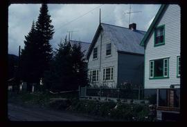
Photograph depicts a house that had a "sold" notice on it and was partly demolished. Up to the date the photograph was captured, this block on Beach Ave. was the sole remaining one to have only houses on it, as opposed to a mixture of houses and apartment blocks, or blocks only.
Photograph depicts a house on the southern edge of Chinatown.
Photograph depicts a house that was probably built in 1890-1900. It had just been demolished.
Photograph depicts one of the few remaining inhabioted and well kept houses that still survived in the very heart of downtown Vancouver.
Photograph depicts a house on Nicola St. at the southwest corner of the intersection of Nicola and Robson St., in Vancouver, B.C.
Photograph depicts a well cared for house that was empty and being stripped along with 3 other house on Barclay to make way for a high rise apartment block. Built circa 1905.
Photograph depicts a house on the east side of Ontario Street, Vancouver.
Photograph depicts a house that had just been repainted on the north side of Pender Street.
Image depicts a house on the shore somewhere on Haida Gwaii.
Image depicts a house being removed from Upper Fraser, B.C. during demolition of town site. A sign on the house reads: "Murray Blackwell House Raising & Moving." Map coordinates 54°06'51.6"N 121°56'26.3"W
Image depicts a house with some Firts Nations' art painted on the front, somewhere on Haida Gwaii, B.C.
Image depicts a house with ivy growing over it. The location is uncertain.
Photograph depicts a house that provided an example of the few surviving homes left on Beach Ave.
Image depicts a set of train tracks, a farmhouse, and some fields; possibly in Woodpecker, B.C.
Image depicts numerous houses, and an unknown child standing in a street at Island Cache.
Image depicts a few houses in Island Cache.
Image depicts a number of houses at an uncertain location, possibly Williams Lake, B.C.
Image depicts many houses somewhere in Wells, B.C.
Image depicts a row of houses somewhere in Wells, B.C.
Image depicts a row of houses in Tumbler Ridge, B.C.
Image depicts a row of houses in Wells, B.C.
Image depicts a row of houses somewhere in Wells, B.C.
Image depicts a row of houses in Tumbler Ridge, B.C.
Image depicts a number of small houses at Island Cache.
Image depicts a few houses in Island Cache. There are two unknown individuals present.
Image depicts a row of houses in Wells, B.C.
Image depicts a few houses and a dog on a porch at Island Cache.
Image depicts many houses somewhere in Wells, B.C.
Image depicts a row of houses in Wells, B.C.
Image depicts a number of small houses at Island Cache.
Part of a set of 41 original black & white photographs [1908-1933-?]) of the Grand Trunk Pacific Railway line in BC depicting surveying crews, town sites (Prince Rupert and its port, Hazelton and Fort George), and First Nations Peoples.
Image depicts a view of numerous houses and a ballpark at an uncertain location. It is possibly located somewhere in the Peace River Region.
Image depicts a row of houses, as well as a United Church of Canada on the right side of the image, located in Wells, B.C.
Image depicts several houses, and three goats standing on a narrow dirt road. The location is uncertain, likely Sinclair Mills, B.C.
Image depicts the Giscome B.C. townsite from across the railroad tracks looking southeast. Map coordinates 54°04'19.7"N 122°22'04.7"W
Photograph depicts a street view looking toward homes build next to a boardwalk, dirt street in the foreground, homes in midground, treed hillsides in the background. Handwritten annotation below photograph reads, "Houses at Naas Harbour".
Image depicts the Giscome B.C. townsite from across the railroad tracks looking southeast. Map coordinates 54°04'19.7"N 122°22'04.7"W
Image depicts a row of houses in Upper Fraser, B.C. Map coordinates 54°06'51.6"N 121°56'26.3"W
Photograph depicts a cluster of small buildings on a hill. Handwritten annotation below photograph reads, "Houses of "Ned" & Barney".
Photograph taken looking northwest at a corner house and another home to its left. They were 2 of 9 houses in this Beach Block, the last block of houses on Beach Ave.
Image depicts houses on Dogwood Street in the Millar Addition neighbourhood of Prince George, B.C. On the left is 1610 Dogwood Street and 1630 Dogwood Street is the middle house; 1650 Dogwood Street is the blue house on the right.
View of peninsula with houses and trees. Dock in mid ground, trees and grasses in foreground. Recto stamped “Port Simpson DE 17" and "Port Essington DE 18". Handwritten annotation on recto of photograph: "W. J. O'Neill Esq. Telegraph Point Via Pt. Essington B.C. Don't you think this pretty [Weggs & Mr. Byron?] was over last night - said he saw you and [Halie?]. Yours - BaBa".
Image depicts a number of houses built on stilts over a body of water in an uncertain location.
Photograph depicts two wood frame houses with gardens, and expanse of lawn in the foreground, a clothes line with fresh laundry in the midground and a treed mountainside in the background. Handwritten annotation reads, "wash day".
Photograph depicts a few houses on Beach Ave., Vancouve. They were examples of about a dozen surviving homes on Beach Ave.
Houston Sawmill - General.