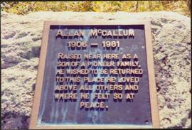
Plan depicts Granville Island industrial sites in False Creek, Vancouver. Shows revised trackage from 1955 annotated in colour by Davies.
File consists of research material regarding Granville Island street railway operations of BC Hydro Railway. Predominantly consists of photocopy reproductions, excerpts from books, and clippings from periodicals. Includes the following works: "The Granville Island Switching Operations of the British Columbia Hydro and Power Authority Railway" by Sochowski and "BCER Granville Island: Extension of Industrial and Interurban Lines within Vancouver City" by Davies.
A comparative study of grassland soils at 3 sites in northwestern BC and southern Yukon was published as:
Sanborn, P. 2010. Topographically controlled grassland soils in the Boreal Cordillera ecozone, northwestern Canada. Canadian Journal of Soil Science 90: 89-101. https://doi.org/10.4141/CJSS09048
This grew out of a field trip with Ministry of Forests range personnel to the Stikine and Tuya River valleys, near Telegraph Creek BC on August 27-28, 2007. (Two pedons were sampled in 2007, BC07-03 and BC07-04, but those results were not included in the paper.)
In August 2008, Dr. Paul Sanborn returned to the Stikine to sample pedon BC08-06, after field work in Yukon which collected the other two pedons used in the paper, from near Carmacks (Y08-39) and Kluane Lake (Y08-41). (An additional pedon from Kluane, Y08-43, was sampled and analyzed, but it was from a forested site and was not included in the paper.)
File contains the following data sets:
- BC & Yukon 2008 soils data – compiled.xls [combined chemical & physical data for BC08-06, Y08-39, Y08-41, Y08-43]
- S925finl.xls [chemical analysis data, Ministry of Forests & Range, Analytical Chemistry Laboratory for pedons BC07-03 & BC07-04; also includes data for Y07-06 & Y07-07 (Klutlan Glacier – see associated file note)]
- S979finl(revised) – PS edits.xls [chemical analysis data, Ministry of Forests & Range, Analytical Chemistry Laboratory for BC08-06, Y08-39, Y08-41, Y08-43]
- S994finl_revised.xls [chemical analysis data, Ministry of Forests & Range, Analytical Chemistry Laboratory for BC07-04 (CaCO3-equiv, total & inorganic C, pyrophosphate, oxalate & dithionite extractions) & selected horizons from BC07-07 & BC07-09 (Nazko basaltic soils))
- CANTEST lab report 91010076.pdf [particle size analyses for BC08-06, Y08-39, Y08-41, Y08-43]
- CANTEST lab report 90206003.pdf [particle size analyses for Tuya pedons BC07-03 & BC07-04 & Klutan Glacier pedons Y07-06 & Y07-07]
File consists of thin section micrograph images from the Boreal Cordilleran grassland soils study (2007 & 2008).
Photograph depicts a landscape shot of a grassy area with fruit-bearing trees in the background.
Image depicts Grassy Plains, B.C.
Photograph depicts a grassy plateau with a tree in the foreground leading to forested foothills and rising to rocky mountain slopes.
Photograph depicts a grassy, snow-covered plateau leading to forested foothills and rising to rocky mountain slopes.
Photograph depicts a grassy plateau leading to forested foothills and rising to rocky mountain slopes.
Photograph depicts a grassy plateau leading to forested foothills and rising rocky mountain slopes.
Photograph depicts a grassy plateau leading to forested foothills and rising to rocky mountain slopes.
Photograph depicts a grave, covered in flowers and surrounded by snow. The grave is marked with what appears to be cement grave markers bordering the burial. The location of the grave is unknown.
Image depicts the grave of Frank Russell "Russ" Baker in Fort St. James, B.C.
Image depicts the grave of W.L. Meason in the upper Fraser Canyon.
Photograph depicts a grave in the churchyard of Murray Church in Nicola, near Merritt. The church was built in 1876, which makes it one of the oldest churches in the interior of B.C. The gravestone shows a death in 1882, of a son aged 14.
Photograph depicts grave marker which reads "ALLAN McCALLUM / 1906 - 1981 / RAISED NEAR HERE AS A SON OF A PIONEER FAMILY, HE WISHED TO BE RETURNED TO THIS PLACE HE LOVED ABOVE ALL OTHERS AND WHERE HE FELT SO AT PEACE."
Image depicts numerous grave markers at an uncertain location.
Image depicts the grave of John A. Cameron at Barkerville, B.C.
Image depicts the grave of John A. Fraser in Barkerville, B.C.
Close up of a grave stone, carved in the shape of an upright bear (?), with a wooden fence visible in background at the Hazelton cemetery. Handwritten annotation on verso reads: "Grave stone in Hazelton graveyard."
Close up of a Hazelton cemetery grave stone carved in the shapes of a fish and a bird. Handwritten annotation on verso reads: "Grave stone in Hazelton graveyard, 1932."
Image depicts layers of gravel at the BCR site in Prince George, B.C.
Photograph depicts close up view of gravel pit, ruler displayed for scale. Photograph speculated to have been taken at the plant or near the Cassiar airstrip. Stamped annotation on recto of photograph: "JUN. 1987".
Photograph depicts a gravel pit 1.5 miles north of the McCulloch depot or at approximately mile 78.0, on the Carmi Subdivision. It has not been in use since at least the late 1950s. The rails here are worn and dated 1910 and 1920s. The view is looking north.
Photograph depicts a gravel pit located 1.5 miles north of McCulloch CPR depot, which is at approximately mile 78, on the Carmi Subdivision. The gravel pit has not been used for at least 20 years. The picture also shows a disused spur line.
Photograph depicts a disused gravel pit near the McCulloch CPR depot, on the Carmi Subdivision. The pit had not been used for at least 20 years. The view is looking south.
Photograph depicts a gravel road carved into the forested landscape.
Photograph depicts a gravel running track at an outdoor field in Friedrichshafen, Germany. This Photograph was taken during Iona Campagnolo's European sports tour.
Photograph depicts two grave sites under flowers in cemetery. Road, trees, and buildings in background.
Photograph depicts two grave sites under flowers in cemetery. Wood planks, field, and forest in background.
Image depicts a small graveyard at an uncertain location.
Photograph depicts a graveyard at a church in Nicola, 7 miles northeast of Merritt. The church was built in 1876, and the cast iron gravestone is unusual.
Photograph depicts a Great Canadian Rail Tour Company train, the Rocky Mountaineer, on CN track, north of Walhachin.
Photograph depicts the rear of the Great Northern depot on Main St. in Vancouver, that is now demolished.