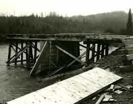
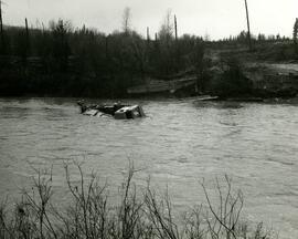
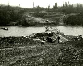
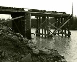
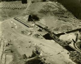
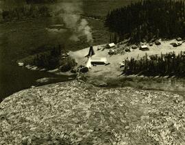
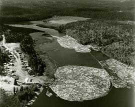
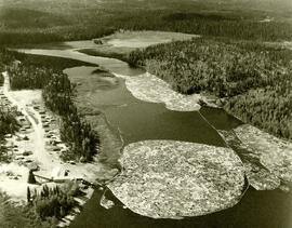
- 2006.20.1.3.46.193
- Item
Parte deNorthern BC Archives Historical Photograph Collection
19838 resultados con objetos digitales Muestra los resultados con objetos digitales
Parte deNorthern BC Archives Historical Photograph Collection
"British Columbia's Skeena Salmon"
Parte deG. Gary Runka fonds
Parte deArchdeacon W. H. Collison fonds
Three Indigenous men stand in a canoe poling their craft along a shoreline while one man sits and steers. An unidentified village is visible along the opposite shore.
Men pushing a Citroen half-track along a muddy mountain path
Parte dePhipps-Mackenzie Collection
Annotation on recto: "I-57370" which denotes the same photograph in the collection of the BC Archives.
This fonds illustrates the life and work of G. Gary Runka and his contributions to the province of British Columbia. Gary Runka was the first General Manager of British Columbia's Agricultural Land Commission and helped establish the provincial Agricultural Land Reserve. After transitioning from a government career to private consulting, Runka provided comprehensive professional services through his land consultancy business, G.G. Runka Land Sense Ltd., offering land capability and environmental assessments, integrated resource management, land and water use conflict resolution, and interdisciplinary land use planning. Described by colleagues as one of BC's most highly respected agrologists and influential land use planners, Runka had a 52-year career working on (or against) an incredible number of landmark projects in British Columbia, such as the Site C Project. Gary Runka’s partner in life and vocation, Joan M. Sawicki, worked with Gary on many of these projects—as well as her own; her contributions are also represented throughout the records of this fonds.
Gary Runka's deep connection to the land is evident from his earliest papers on aerial photo interpretation, his work with the Canada Land Inventory, through his speeches and his work establishing the BC Agricultural Land Reserve and in his subsequent consulting career through G.G. Runka Land Sense Ltd. Gary Runka's influence and legacy was recognized in the tributes paid after his death, including the post-humus award as the Real Estate Foundation's "Land Champion" for 2014.
The G. Gary Runka fonds has been divided into the following nine series:
1) Personal Records
2) Speeches & Publications
3) Professional Records
4) Agricultural Land Commission
5) Land Sense Ltd.
6) Client Files
7) Maps
8) Photographs
9) Digital Records
Sin título
Beaver Trucking, Kamloops Indian Reserve No.1
Parte deDavid Davies Railway Collection
Photograph depicts Beaver Trucking located on Kamloops Indian Reserve No. 1 on Tk'emlups te Secwepemc territory, Kamloops, BC. It had been a company since 1990 and received 2 or 3 boxcars weekly loaded with items from Toronto that were then delivered around town. Davies later noted that the business was destroyed by arson in 1997.
Wuikinuxv (?) Totem Pole, Rivers Inlet, B.C
Parte deReverend R.W. Large fonds
Photograph depicts a totem pole along a shoreline with canoes overturned at its base. A forested area is visible in the background. Pole is likely on the territory of the Wuikinuxv Nation, also known as the Oweekeno Nation whose traditional territory includes the shores of Rivers Inlet and Owikeno Lake. Annotation on recto of photograph states: "Indian Totem Pole, Rivers Inlet, B.C"
Tsimshian mortuary poles in Prince Rupert
Parte deArchdeacon W. H. Collison fonds
Photograph of three Tsimshian mortuary poles. Two crossed logs rest atop the three poles. Annotation on recto reads: "Indian Mortuary Poles Nr Prince Rupert BC McRae Bros."
Tsimshian village at Lax-Kw'alaams (Port Simpson) BC
Hand coloured photograph of the surrounding lands and many residential buildings encompassing the Tsimshian village of Lax Kw'alaams (previously called Port Simpson). Printed annotation on recto reads: "Indian Village, Port Simpson, B.C."
Haida totem pole, Massett, B.C
Parte deReverend R.W. Large fonds
Photograph depicts a Haida crest carving on a wooden pole in front of a house. Annotation on recto of photograph states: "Indian Totem Pole, Massett B.C."
Hagwilget Bridge, Bulkley River
Parte deReverend R.W. Large fonds
Photograph depicts the wooden Hagwilget Bridge spanning a rocky gorge over the Bulkley River. Forested area visible in the background. Annotation on recto of photograph states: "W.W.W. Old Indian Bridge, Bulkley River"
Man stands behind a Gitksan petroglyph discovered along the Upper Skeena River at Kispiox (?)
Parte deReverend R.W. Large fonds
Photograph depicts an unidentified Indigenous (Gitksan?) man standing on a porch behind a stone petroglyph found at Kispiox village along the Upper Skeena River. Annotation on recto of photograph states: "Indian stone relic unearthed at Kispaiyeks Indian Village, B.C., Upper Skeena River".
Church on Tsal'alh Nation territory
Parte deDavid Davies Railway Collection
Photograph depicts a church that was built of shaped logs on the territory of the Tsal'alh Nation on the road leading to Seton Lake. Church was derelict, but still held pews, plastic flowers and small shrines.
Gitksan Totem Poles, Kitwanga, BC
Full on photograph of a totem pole in a fenced area. Printed annotation on recto reads: "Indian Totem Poles, Kitwanga, B.C."
4-wheel cart at Tsalalh (Seton Lake) First Nation
Parte deDavid Davies Railway Collection
Photograph depicts a 4-wheeled cart located on Tsalalh Nation territory at the head of Seton Lake.
Wooden church at Lheidli T'enneh village site
Side view of a wooden church, possibly under construction, and other buildings. Printed annotation on recto reads: "Indian Village- Prince George."
First Nations Village at Fraser Lake
Photograph depicts a cluster of buildings near Fraser Lake. A fence and grasses in the foreground. Original photo title: "Indian Village at Fraser Lake." First Nations communities with territories overlapping Fraser Lake include Nadleh Whut'en and Stellat'en Nations.
Photograph depicts Lheidli T'enneh Nation burial grounds in foreground, Hudson Bay Company buildings in background.
Photograph depicts a cluster of wooden buildings including a flagpole and church spire at a Lheidli T'enneh village site. Original photo identified this image as "Indian Village, Fort George".
Anglican priests of the Nisga’a
Photograph depicts three Anglican priests that served Nisga’a communities in the Nass Valley of British Columbia. They have been identified as (left to right): Father John Hannen (serving Gingolx, later Bishop of the Anglican Diocese of Caledonia), Father John Blyth (serving Gitlaxt'aamiks), and Father David Retter (serving Laxgalts'ap).
Gary Runka receives Agricultural Institute of Canada Fellow
Parte deG. Gary Runka fonds
Photograph depicts Gary Runka receiving a Agricultural Institute of Canada Fellow award at the 1990 AIC Convention at the Penticton Conference Centre.
Aerial photograph of West Coast Trail at Nitinat Narrows
Parte deG. Gary Runka fonds
Air photograph depicts a segment of the West Coast Trail showing the beach area around the cabins at Nitinat Narrows. Coding on aerial is "BCO 390".
Aerial photograph of West Coast Trail at Carmanah Lighthouse
Parte deG. Gary Runka fonds
Air photograph depicts a segment of the West Coast Trail showing the beach area around the Carmanah Point Light Station. Coding on aerial is "BCO 391".
Photo identification key overlay sheet
Parte deG. Gary Runka fonds
Photograph is a group portrait of the attendees at the Federal-Provincial Canada Land Inventory Coordinators Meeting in Victoria, March 31-April 1, 1971. Starting from the back row, left to right, attendees included: John Senyk, B.C.; Jim Allin, B.C.; Fred Frederickson, B.C.; Red Ward, Ontario; George Rathwell, Saskatchewan; John Foster, Ottawa, Charlie Rowles, B.C.; David Glover, Ottawa; Bill Yeomans, B.C.; Don Coombs, Ottawa; Harold Hoyt, N.B.; Brian King, Ottawa; Art Benson, B.C.; Scott Johnston, Ottawa; Dan Blower, B.C.; Vic Solman, Ottawa; Don Benn, B.C.; Dick Spilsbury, B.C.; Les Lavkulich, B.C.; Doug Lacate, B.C.; John Wilcox, B.C.; Alf Leahey, B.C.; Mike Romaine, Ottawa; Dick Marshall, B.C.; Gary Runka, B.C.; Norm Sprout, B.C.; Ken Beanlands, Newfoundland; Mick Roberts, Ottawa; Paul Lajoie, Ottawa; Pat Duffy, Ottawa; Bert Brink, B.C.; Merv McKay, Manitoba; Rich Goulden, Manitoba; Reg McCormack, Ottawa; Gerry Howell-Jones, B.C.; Marcel Belzile, Quebec; Paul Deane, Ottawa; Laurie Farstad, B.C.; Stu Scott, Alberta.
Canada National Land Use meeting group portrait
Parte deG. Gary Runka fonds
Photograph is a group portrait of the attendees at a Canada National Land Use meeting. Back row, left to right: Gary Runka, Bruce Chambers, Frank Heaps, Vern Spencer, Peter Whiting. Middle row, left to right: Bob Scace, Lee Munn, Bill Bourgeois, Jim Murphy, Gerry Acott, Dave Rochefort. Front row, left to right: Mike Simmons, Les Cooke, John Hetherington, Betty McGregor, Daniel Paquette, Peggy Thompson, Patsy Murphy.
BC Agricultural Land Commission staff Christmas party
Parte deG. Gary Runka fonds
Photograph is a group portrait of BC Agricultural Land Commission staff members at a Christmas party. Back row, left to right: Patti, Terry Lewis, unknown, Julie Glover, Gordon Gram, Gary Holisko, Kirk Miller, unknown, Shirley Brightman. Middle row, left to right: Eve Lew, Jim Plotnikoff (Santa). Front row, left to right: Verona Hoosen, unknown, Jane Perch, Denise Jankovich, unknown, unknown.
Agricultural Institute of Canada Fellows, 1990
Parte deG. Gary Runka fonds
Photograph depicts recipients of the 1990 Agricultural Institute of Canada Fellow award at the 1990 AIC Convention at the Penticton Conference Centre. Gary Runka is third from right.
Aerial photograph of West Coast Trail at Tsusiat Falls
Parte deG. Gary Runka fonds
Air photograph depicts a segment of the West Coast Trail showing the beach area around Tsusiat Falls. Coding on aerial is "BCO 387".
Aerial photograph of West Coast Trail at Tsusiat Point Hole in the Wall
Parte deG. Gary Runka fonds
Air photograph depicts a segment of the West Coast Trail showing the beach area around Tsusiat Point Hole in the Wall. Coding on aerial is "BCO 389".
Aerial photograph of West Coast Trail at Tsusiat Falls
Parte deG. Gary Runka fonds
Air photograph depicts a segment of the West Coast Trail showing the beach area around Tsusiat Falls. Coding on aerial is "BCO 388".
G. Gary Runka, UBC Graduation Portrait
Parte deG. Gary Runka fonds
Curling team at Summerland Curling Club event
Parte deG. Gary Runka fonds
Photograph depicts a curling team at a Feb. 1964 Summerland Curling Club event. Trophy at centre reads "L.A. Smith Ltd. Event". From left to right: Unknown, Brian McCormick, Gary Runka, Art (surname unknown).
BC Canada Land Inventory Group
Parte deG. Gary Runka fonds
Photograph is a group portrait of the British Columbia Canada Land Inventory team. Back row, left to right: Rob Hawes, unknown, Ivan Cotic, Terje Vold, John Wilcox [?], Keith Valentine, unknown, Alec Green [?], Horst Baender, Dick Marshall, unknown, John Senyk, Bill Watt, Neville Gough, Dan Blower, unknown, Gavin Young, Craig Brownlee. Middle row, left to right: unknown, Peter Murtha, unknown, unknown, John Harris, Al Aldred, Gary Runka, Ed Oswald, Mary Redmond. Front row, left to right: Rick Williams, Gerry Howell-Jones, Chris Stanley-Jones, Larry Lacelle, John Jungen, Tom Pierce, Jim Van Barneveld.
North Peace High School 1957 class photograph
Parte deG. Gary Runka fonds
Photograph depicts the North Peace High School Class of 1957 of Fort St. John. G. Gary Runka is the third from the left, back row. Other individuals are unidentified.
1956 High School Curling Peace River District champions
Parte deG. Gary Runka fonds
Photograph depicts the 1956 High School Curling Peace River District champions of the Peace Curling Association. Coach at centre. G. Gary Runka at far right.
Canada Land Inventory National Soil Survey [?] group portrait
Parte deG. Gary Runka fonds
Photograph is a group portrait of the Canada Land Inventory team , possibly related to the National Soil Survey. Individuals identified: Norm Sprout (back row, 5th from left); Les Lavkulich (back row, 6th from left); Dr. Charlie Rowles (back row, 6th from right); Pat Duffy (3rd row back, 6th from right); Gary Runka (3rd row back, 5th from right).
Federal-Provincial Canada Land Inventory Coordinators Meeting in Victoria
Parte deG. Gary Runka fonds
Photograph is a group portrait of the attendees at the Federal-Provincial Canada Land Inventory Coordinators Meeting in Victoria, March 31-April 1, 1971. Starting from the back row, left to right, attendees included: John Senyk, B.C.; Jim Allin, B.C.; Fred Frederickson, B.C.; Red Ward, Ontario; George Rathwell, Saskatchewan; John Foster, Ottawa, Charlie Rowles, B.C.; David Glover, Ottawa; Bill Yeomans, B.C.; Don Coombs, Ottawa; Harold Hoyt, N.B.; Brian King, Ottawa; Art Benson, B.C.; Scott Johnston, Ottawa; Dan Blower, B.C.; Vic Solman, Ottawa; Don Benn, B.C.; Dick Spilsbury, B.C.; Les Lavkulich, B.C.; Doug Lacate, B.C.; John Wilcox, B.C.; Alf Leahey, B.C.; Mike Romaine, Ottawa; Dick Marshall, B.C.; Gary Runka, B.C.; Norm Sprout, B.C.; Ken Beanlands, Newfoundland; Mick Roberts, Ottawa; Paul Lajoie, Ottawa; Pat Duffy, Ottawa; Bert Brink, B.C.; Merv McKay, Manitoba; Rich Goulden, Manitoba; Reg McCormack, Ottawa; Gerry Howell-Jones, B.C.; Marcel Belzile, Quebec; Paul Deane, Ottawa; Laurie Farstad, B.C.; Stu Scott, Alberta.
Two young, unidentified Indigenous siblings posing for a portrait at a Christian Mission
Parte deReverend R.W. Large fonds
Photograph depicts a First Nations man seated on a chair beside his younger sister. Annotation on verso of photograph states: "Canada B.C Indian mission Indian and his little sister"
Bella Bella Church decorated for Christmas
Parte deReverend R.W. Large fonds
Photograph depicts the interior of a church decorated with white streamers. Annotation on verso states: "Canada, B.C., Indian(?) Bella Bella Church decorated for Christmas by Indian "decoration""
Indigenous Cemetery, Hazelton BC
Parte deArchdeacon W. H. Collison fonds
Hand coloured photograph of a cemetery in Gitxsan territory. Annotation on recto reads: "Indian Cemetery, Hazelton, BC."
Parte deDavid Davies Railway Collection
Photograph depicts the CPR line at Revelstoke. The present terminus is about 1 mile south of the mainline depot of the former Arrowhead branch line (27.5 miles long) which became submerged when Arrow Lake was raised 70 ft. in 1968-1969.
Parte deDavid Davies Railway Collection
Plan depicts Granville Island industrial sites in False Creek, Vancouver. Shows revised trackage from 1955 annotated in colour by Davies.
Mountain ridge rising out of alpine lake
Parte dePrentiss Gray Collection
Photograph depicts a mountain ridge rising our of an alpine lake that is visible in the foreground. The photograph location is the Mt. Petrie area from the north and northwest.
Mountain ridge rising out of alpine lake
Parte dePrentiss Gray Collection
Photograph depicts a mountain ridge rising out of an alpine lake. The photograph location is the Mt. Petrie area from the north and northwest.
Top of mountain ridge situated next to an alpine lake
Parte dePrentiss Gray Collection
Photograph depicts the top of a mountain ridge situated next to an alpine lake. The photograph location is the Mt. Petrie area from the north and northwest.
Top of mountain peak situated above an alpine lake
Parte dePrentiss Gray Collection
Photograph depicts the craggy top of a mountain peak situated above an alpine lake. The location of the photograph is the Mt. Petrie area from the north and northwest.
Mountain peak rising out of an alpine lake
Parte dePrentiss Gray Collection
Photograph depicts a mountain peak rising above an alpine lake. The photograph location is the Mt. Petrie area from the north and northwest.
(L-R) Bob Potts, Joe (?) Callao and an unidentified man looking for game from a hilltop cairn
Parte dePrentiss Gray Collection
(L-R) George Bates, Harry Snyder and Carrol Paul seated behind their trophy ram heads
Parte dePrentiss Gray Collection